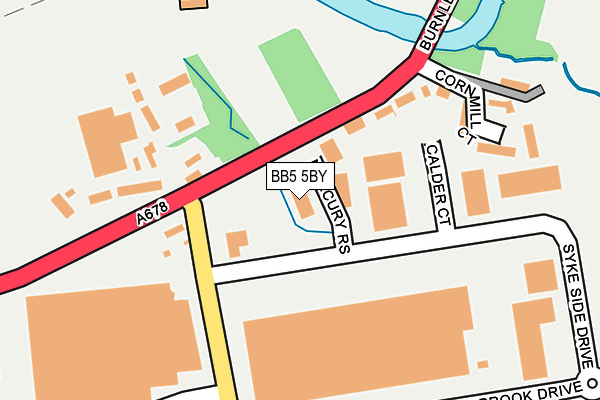
BB5 5BY lies on Mercury Rise in Altham, Accrington. BB5 5BY is located in the Altham electoral ward, within the local authority district of Hyndburn and the English Parliamentary constituency of Hyndburn. The Sub Integrated Care Board (ICB) Location is NHS Lancashire and South Cumbria ICB - 01A and the police force is Lancashire. This postcode has been in use since January 2009.


GetTheData
Source: OS OpenMap – Local (Ordnance Survey)
Source: OS VectorMap District (Ordnance Survey)
Licence: Open Government Licence (requires attribution)
| Easting | 377317 |
| Northing | 432906 |
| Latitude | 53.791982 |
| Longitude | -2.345801 |
GetTheData
Source: Open Postcode Geo
Licence: Open Government Licence
| Street | Mercury Rise |
| Locality | Altham |
| Town/City | Accrington |
| Country | England |
| Postcode District | BB5 |
| ➜ BB5 open data dashboard ➜ See where BB5 is on a map ➜ Where is Altham? | |
GetTheData
Source: Land Registry Price Paid Data
Licence: Open Government Licence
Elevation or altitude of BB5 5BY as distance above sea level:
| Metres | Feet | |
|---|---|---|
| Elevation | 70m | 230ft |
Elevation is measured from the approximate centre of the postcode, to the nearest point on an OS contour line from OS Terrain 50, which has contour spacing of ten vertical metres.
➜ How high above sea level am I? Find the elevation of your current position using your device's GPS.
GetTheData
Source: Open Postcode Elevation
Licence: Open Government Licence
| Ward | Altham |
| Constituency | Hyndburn |
GetTheData
Source: ONS Postcode Database
Licence: Open Government Licence
| May 2022 | Other theft | On or near Cornmill Court | 154m |
| May 2022 | Anti-social behaviour | On or near Shorten Brook Drive | 265m |
| March 2022 | Anti-social behaviour | On or near Mercury Rise | 26m |
| ➜ Mercury Rise crime map and outcomes | |||
GetTheData
Source: data.police.uk
Licence: Open Government Licence
| Syke Side Drive | Altham | 98m |
| Walton Arms (Burnley Road) | Altham | 110m |
| Walton Arms (Burnley Road) | Altham | 191m |
| Shorton Brook Drive (Shorten Brook Drive) | Altham | 256m |
| Simon Jersey (Syke Side Drive) | Altham | 299m |
| Hapton Station | 2.2km |
| Huncoat Station | 2.2km |
| Rose Grove Station | 4.2km |
GetTheData
Source: NaPTAN
Licence: Open Government Licence
GetTheData
Source: ONS Postcode Database
Licence: Open Government Licence


➜ Get more ratings from the Food Standards Agency
GetTheData
Source: Food Standards Agency
Licence: FSA terms & conditions
| Last Collection | |||
|---|---|---|---|
| Location | Mon-Fri | Sat | Distance |
| 216 Willows Lane | 17:00 | 12:45 | 1,989m |
| Padiham Post Office | 18:00 | 11:00 | 2,328m |
| Burnley Road | 17:30 | 11:00 | 2,351m |
GetTheData
Source: Dracos
Licence: Creative Commons Attribution-ShareAlike
| Facility | Distance |
|---|---|
| Altham St James Church Of England Primary School Burnley Road, Altham, Accrington Grass Pitches | 460m |
| Read United Football Club Whalley Road, Read, Burnley Grass Pitches | 1.5km |
| Simonstone St Peter's C Of E Primary School School Lane, Simonstone, Burnley Grass Pitches | 1.6km |
GetTheData
Source: Active Places
Licence: Open Government Licence
| School | Phase of Education | Distance |
|---|---|---|
| Altham St James Church of England Primary School Altham St James CE Primary School, Burnley Road, Altham, Accrington, BB5 5UH | Primary | 459m |
| Simonstone St Peter's Church of England Primary School School Lane, Simonstone, Burnley, BB12 7HR | Primary | 1.6km |
| Read St John's CofE Primary School Straits Lane, READ, Burnley, BB12 7PE | Primary | 1.8km |
GetTheData
Source: Edubase
Licence: Open Government Licence
The below table lists the International Territorial Level (ITL) codes (formerly Nomenclature of Territorial Units for Statistics (NUTS) codes) and Local Administrative Units (LAU) codes for BB5 5BY:
| ITL 1 Code | Name |
|---|---|
| TLD | North West (England) |
| ITL 2 Code | Name |
| TLD4 | Lancashire |
| ITL 3 Code | Name |
| TLD46 | East Lancashire |
| LAU 1 Code | Name |
| E07000120 | Hyndburn |
GetTheData
Source: ONS Postcode Directory
Licence: Open Government Licence
The below table lists the Census Output Area (OA), Lower Layer Super Output Area (LSOA), and Middle Layer Super Output Area (MSOA) for BB5 5BY:
| Code | Name | |
|---|---|---|
| OA | E00127062 | |
| LSOA | E01025033 | Hyndburn 002B |
| MSOA | E02005213 | Hyndburn 002 |
GetTheData
Source: ONS Postcode Directory
Licence: Open Government Licence
| BB5 5UW | River Bank Terrace | 99m |
| BB5 5LE | Cornmill Court | 160m |
| BB5 5UP | Burnley Road | 172m |
| BB5 5UR | Altham Lane | 174m |
| BB5 5UJ | New Row | 200m |
| BB5 5UL | Burnley Road | 232m |
| BB12 7NL | Altham Pumping Station | 305m |
| BB5 5UQ | Burnley Road | 536m |
| BB5 5WJ | Barnfield Way | 618m |
| BB12 7NN | Railway Terrace | 641m |
GetTheData
Source: Open Postcode Geo; Land Registry Price Paid Data
Licence: Open Government Licence