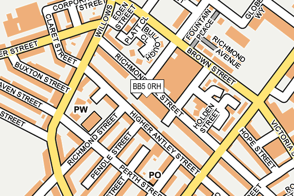
BB5 0RH is located in the Central electoral ward, within the local authority district of Hyndburn and the English Parliamentary constituency of Hyndburn. The Sub Integrated Care Board (ICB) Location is NHS Lancashire and South Cumbria ICB - 01A and the police force is Lancashire. This postcode has been in use since January 1980.


GetTheData
Source: OS OpenMap – Local (Ordnance Survey)
Source: OS VectorMap District (Ordnance Survey)
Licence: Open Government Licence (requires attribution)
| Easting | 375478 |
| Northing | 428191 |
| Latitude | 53.749506 |
| Longitude | -2.373339 |
GetTheData
Source: Open Postcode Geo
Licence: Open Government Licence
| Country | England |
| Postcode District | BB5 |
➜ See where BB5 is on a map ➜ Where is Accrington? | |
GetTheData
Source: Land Registry Price Paid Data
Licence: Open Government Licence
Elevation or altitude of BB5 0RH as distance above sea level:
| Metres | Feet | |
|---|---|---|
| Elevation | 160m | 525ft |
Elevation is measured from the approximate centre of the postcode, to the nearest point on an OS contour line from OS Terrain 50, which has contour spacing of ten vertical metres.
➜ How high above sea level am I? Find the elevation of your current position using your device's GPS.
GetTheData
Source: Open Postcode Elevation
Licence: Open Government Licence
| Ward | Central |
| Constituency | Hyndburn |
GetTheData
Source: ONS Postcode Database
Licence: Open Government Licence
| Charter Street (Willows Lane) | Spring Hill | 154m |
| Buxton Street (Willows Lane) | Spring Hill | 155m |
| Charter Street (Willows Lane) | Spring Hill | 165m |
| Buxton Street (Willows Lane) | Spring Hill | 173m |
| Higher Antley Street (Ormerod Street) | Scaitcliffe | 185m |
| Accrington Station | 0.5km |
| Church & Oswaldtwistle Station | 1.2km |
| Huncoat Station | 3km |
GetTheData
Source: NaPTAN
Licence: Open Government Licence
GetTheData
Source: ONS Postcode Database
Licence: Open Government Licence


➜ Get more ratings from the Food Standards Agency
GetTheData
Source: Food Standards Agency
Licence: FSA terms & conditions
| Last Collection | |||
|---|---|---|---|
| Location | Mon-Fri | Sat | Distance |
| Oswaldtwistle P.o. | 16:30 | 12:00 | 1,706m |
| 52 Lancaster Avenue | 16:15 | 11:15 | 2,135m |
| Thwaites Road | 16:00 | 11:00 | 2,144m |
GetTheData
Source: Dracos
Licence: Creative Commons Attribution-ShareAlike
The below table lists the International Territorial Level (ITL) codes (formerly Nomenclature of Territorial Units for Statistics (NUTS) codes) and Local Administrative Units (LAU) codes for BB5 0RH:
| ITL 1 Code | Name |
|---|---|
| TLD | North West (England) |
| ITL 2 Code | Name |
| TLD4 | Lancashire |
| ITL 3 Code | Name |
| TLD46 | East Lancashire |
| LAU 1 Code | Name |
| E07000120 | Hyndburn |
GetTheData
Source: ONS Postcode Directory
Licence: Open Government Licence
The below table lists the Census Output Area (OA), Lower Layer Super Output Area (LSOA), and Middle Layer Super Output Area (MSOA) for BB5 0RH:
| Code | Name | |
|---|---|---|
| OA | E00171916 | |
| LSOA | E01025042 | Hyndburn 006B |
| MSOA | E02005217 | Hyndburn 006 |
GetTheData
Source: ONS Postcode Directory
Licence: Open Government Licence
| BB5 0SN | Higher Antley Street | 46m |
| BB5 0QS | Fountain Street | 61m |
| BB5 0SP | Richmond Hill Street | 95m |
| BB5 0QT | Richmond Hill Street | 110m |
| BB5 0SW | Rowland Street | 111m |
| BB5 0QX | Hannah Street | 123m |
| BB5 0SL | Pendle Street | 132m |
| BB5 0QU | Holden Street | 136m |
| BB5 0QH | Higher Antley Street | 141m |
| BB5 0SJ | Richmond Street | 149m |
GetTheData
Source: Open Postcode Geo; Land Registry Price Paid Data
Licence: Open Government Licence