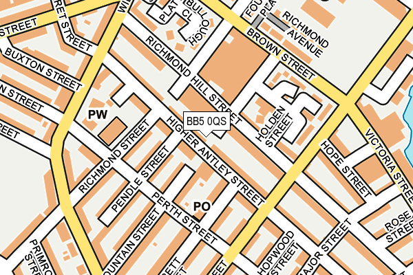
BB5 0QS lies on Fountain Street in Accrington. BB5 0QS is located in the Central electoral ward, within the local authority district of Hyndburn and the English Parliamentary constituency of Hyndburn. The Sub Integrated Care Board (ICB) Location is NHS Lancashire and South Cumbria ICB - 01A and the police force is Lancashire. This postcode has been in use since January 1980.


GetTheData
Source: OS OpenMap – Local (Ordnance Survey)
Source: OS VectorMap District (Ordnance Survey)
Licence: Open Government Licence (requires attribution)
| Easting | 375501 |
| Northing | 428134 |
| Latitude | 53.748995 |
| Longitude | -2.372985 |
GetTheData
Source: Open Postcode Geo
Licence: Open Government Licence
| Street | Fountain Street |
| Town/City | Accrington |
| Country | England |
| Postcode District | BB5 |
| ➜ BB5 open data dashboard ➜ See where BB5 is on a map ➜ Where is Accrington? | |
GetTheData
Source: Land Registry Price Paid Data
Licence: Open Government Licence
Elevation or altitude of BB5 0QS as distance above sea level:
| Metres | Feet | |
|---|---|---|
| Elevation | 160m | 525ft |
Elevation is measured from the approximate centre of the postcode, to the nearest point on an OS contour line from OS Terrain 50, which has contour spacing of ten vertical metres.
➜ How high above sea level am I? Find the elevation of your current position using your device's GPS.
GetTheData
Source: Open Postcode Elevation
Licence: Open Government Licence
| Ward | Central |
| Constituency | Hyndburn |
GetTheData
Source: ONS Postcode Database
Licence: Open Government Licence
| January 2024 | Anti-social behaviour | On or near Parking Area | 334m |
| January 2024 | Anti-social behaviour | On or near Parking Area | 334m |
| January 2024 | Violence and sexual offences | On or near Parking Area | 334m |
| ➜ Fountain Street crime map and outcomes | |||
GetTheData
Source: data.police.uk
Licence: Open Government Licence
| Higher Antley Street (Ormerod Street) | Scaitcliffe | 127m |
| Hope Street (Ormerod Street) | Scaitcliffe | 136m |
| Brown Street | Scaitcliffe | 178m |
| Brown Street | Scaitcliffe | 184m |
| Buxton Street (Willows Lane) | Spring Hill | 190m |
| Accrington Station | 0.5km |
| Church & Oswaldtwistle Station | 1.2km |
| Huncoat Station | 3km |
GetTheData
Source: NaPTAN
Licence: Open Government Licence
| Percentage of properties with Next Generation Access | 100.0% |
| Percentage of properties with Superfast Broadband | 100.0% |
| Percentage of properties with Ultrafast Broadband | 100.0% |
| Percentage of properties with Full Fibre Broadband | 0.0% |
Superfast Broadband is between 30Mbps and 300Mbps
Ultrafast Broadband is > 300Mbps
| Percentage of properties unable to receive 2Mbps | 0.0% |
| Percentage of properties unable to receive 5Mbps | 0.0% |
| Percentage of properties unable to receive 10Mbps | 0.0% |
| Percentage of properties unable to receive 30Mbps | 0.0% |
GetTheData
Source: Ofcom
Licence: Ofcom Terms of Use (requires attribution)
GetTheData
Source: ONS Postcode Database
Licence: Open Government Licence


➜ Get more ratings from the Food Standards Agency
GetTheData
Source: Food Standards Agency
Licence: FSA terms & conditions
| Last Collection | |||
|---|---|---|---|
| Location | Mon-Fri | Sat | Distance |
| Oswaldtwistle P.o. | 16:30 | 12:00 | 1,705m |
| 52 Lancaster Avenue | 16:15 | 11:15 | 2,131m |
| Thwaites Road | 16:00 | 11:00 | 2,160m |
GetTheData
Source: Dracos
Licence: Creative Commons Attribution-ShareAlike
| Facility | Distance |
|---|---|
| Energie Fitness Club (Accrington) (Closed) The Globe Centre, St. James Square, Accrington Health and Fitness Gym, Studio | 326m |
| The Zone Hyndburn New Era Complex Paradise Street, Accrington Health and Fitness Gym, Sports Hall | 539m |
| Bullough Park Playing Fields Park Crescent, Accrington Grass Pitches | 555m |
GetTheData
Source: Active Places
Licence: Open Government Licence
| School | Phase of Education | Distance |
|---|---|---|
| Accrington Spring Hill Community Primary School Exchange Street, Accrington, BB5 0JD | Primary | 398m |
| Mount Carmel Roman Catholic High School, Hyndburn Wordsworth Road, Accrington, BB5 0LU | Secondary | 569m |
| Fairfield Nursery School Fairfield Street, Accrington, BB5 0LD | Nursery | 639m |
GetTheData
Source: Edubase
Licence: Open Government Licence
The below table lists the International Territorial Level (ITL) codes (formerly Nomenclature of Territorial Units for Statistics (NUTS) codes) and Local Administrative Units (LAU) codes for BB5 0QS:
| ITL 1 Code | Name |
|---|---|
| TLD | North West (England) |
| ITL 2 Code | Name |
| TLD4 | Lancashire |
| ITL 3 Code | Name |
| TLD46 | East Lancashire |
| LAU 1 Code | Name |
| E07000120 | Hyndburn |
GetTheData
Source: ONS Postcode Directory
Licence: Open Government Licence
The below table lists the Census Output Area (OA), Lower Layer Super Output Area (LSOA), and Middle Layer Super Output Area (MSOA) for BB5 0QS:
| Code | Name | |
|---|---|---|
| OA | E00171916 | |
| LSOA | E01025042 | Hyndburn 006B |
| MSOA | E02005217 | Hyndburn 006 |
GetTheData
Source: ONS Postcode Directory
Licence: Open Government Licence
| BB5 0QT | Richmond Hill Street | 63m |
| BB5 0QH | Higher Antley Street | 83m |
| BB5 0SN | Higher Antley Street | 90m |
| BB5 0QJ | Garbett Street | 90m |
| BB5 0QX | Hannah Street | 104m |
| BB5 0SL | Pendle Street | 115m |
| BB5 0QU | Holden Street | 116m |
| BB5 0QR | Fountain Street | 128m |
| BB5 0QL | Perth Street | 133m |
| BB5 0SJ | Richmond Street | 139m |
GetTheData
Source: Open Postcode Geo; Land Registry Price Paid Data
Licence: Open Government Licence