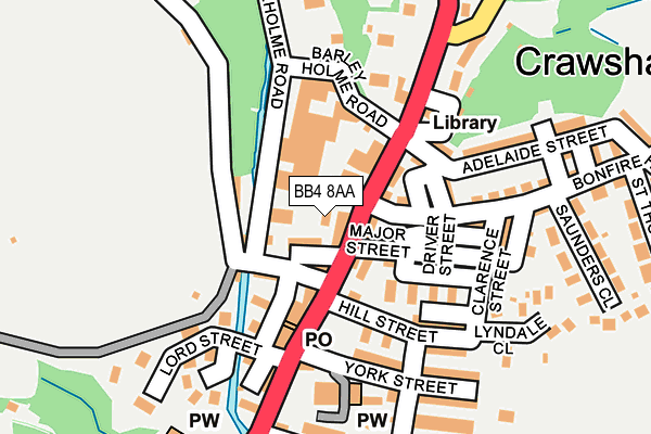
BB4 8AA is located in the Goodshaw electoral ward, within the local authority district of Rossendale and the English Parliamentary constituency of Rossendale and Darwen. The Sub Integrated Care Board (ICB) Location is NHS Lancashire and South Cumbria ICB - 01A and the police force is Lancashire. This postcode has been in use since June 2000.


GetTheData
Source: OS OpenMap – Local (Ordnance Survey)
Source: OS VectorMap District (Ordnance Survey)
Licence: Open Government Licence (requires attribution)
| Easting | 381139 |
| Northing | 425387 |
| Latitude | 53.724541 |
| Longitude | -2.287323 |
GetTheData
Source: Open Postcode Geo
Licence: Open Government Licence
| Country | England |
| Postcode District | BB4 |
➜ See where BB4 is on a map ➜ Where is Rawtenstall? | |
GetTheData
Source: Land Registry Price Paid Data
Licence: Open Government Licence
Elevation or altitude of BB4 8AA as distance above sea level:
| Metres | Feet | |
|---|---|---|
| Elevation | 210m | 689ft |
Elevation is measured from the approximate centre of the postcode, to the nearest point on an OS contour line from OS Terrain 50, which has contour spacing of ten vertical metres.
➜ How high above sea level am I? Find the elevation of your current position using your device's GPS.
GetTheData
Source: Open Postcode Elevation
Licence: Open Government Licence
| Ward | Goodshaw |
| Constituency | Rossendale And Darwen |
GetTheData
Source: ONS Postcode Database
Licence: Open Government Licence
| Black Dog (Burnley Road) | Crawshawbooth | 82m |
| Adelaide Street (Burnley Road) | Crawshawbooth | 91m |
| Black Dog (Burnley Road) | Crawshawbooth | 94m |
| Adelaide Street (Burnley Road) | Crawshawbooth | 116m |
| Primary School (Burnley Road) | Crawshawbooth | 384m |
GetTheData
Source: NaPTAN
Licence: Open Government Licence
GetTheData
Source: ONS Postcode Database
Licence: Open Government Licence


➜ Get more ratings from the Food Standards Agency
GetTheData
Source: Food Standards Agency
Licence: FSA terms & conditions
| Last Collection | |||
|---|---|---|---|
| Location | Mon-Fri | Sat | Distance |
| Rossendale Delivery Office | 17:45 | 13:00 | 2,531m |
| Railway Station | 16:45 | 12:30 | 2,852m |
| Newchurch Road | 17:30 | 11:30 | 2,897m |
GetTheData
Source: Dracos
Licence: Creative Commons Attribution-ShareAlike
| Risk of BB4 8AA flooding from rivers and sea | Medium |
| ➜ BB4 8AA flood map | |
GetTheData
Source: Open Flood Risk by Postcode
Licence: Open Government Licence
The below table lists the International Territorial Level (ITL) codes (formerly Nomenclature of Territorial Units for Statistics (NUTS) codes) and Local Administrative Units (LAU) codes for BB4 8AA:
| ITL 1 Code | Name |
|---|---|
| TLD | North West (England) |
| ITL 2 Code | Name |
| TLD4 | Lancashire |
| ITL 3 Code | Name |
| TLD46 | East Lancashire |
| LAU 1 Code | Name |
| E07000125 | Rossendale |
GetTheData
Source: ONS Postcode Directory
Licence: Open Government Licence
The below table lists the Census Output Area (OA), Lower Layer Super Output Area (LSOA), and Middle Layer Super Output Area (MSOA) for BB4 8AA:
| Code | Name | |
|---|---|---|
| OA | E00128729 | |
| LSOA | E01025361 | Rossendale 001B |
| MSOA | E02005278 | Rossendale 001 |
GetTheData
Source: ONS Postcode Directory
Licence: Open Government Licence
| BB4 8AH | Mansion House Buildings | 34m |
| BB4 8NJ | Post Office Street | 58m |
| BB4 8AG | Co Operation Street | 69m |
| BB4 8AW | Parrock Parade | 72m |
| BB4 8AX | Barley Holme Road | 80m |
| BB4 8AQ | Woodnook | 85m |
| BB4 8PQ | Parrock Street | 96m |
| BB4 8PB | Minor Street | 102m |
| BB4 8PA | Spring Buildings | 105m |
| BB4 8AJ | Burnley Road | 107m |
GetTheData
Source: Open Postcode Geo; Land Registry Price Paid Data
Licence: Open Government Licence