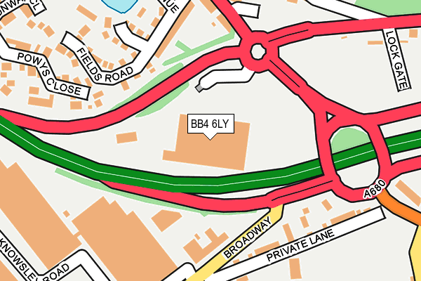
BB4 6LY is located in the Greenfield electoral ward, within the local authority district of Rossendale and the English Parliamentary constituency of Hyndburn. The Sub Integrated Care Board (ICB) Location is NHS Lancashire and South Cumbria ICB - 01A and the police force is Lancashire. This postcode has been in use since September 2002.


GetTheData
Source: OS OpenMap – Local (Ordnance Survey)
Source: OS VectorMap District (Ordnance Survey)
Licence: Open Government Licence (requires attribution)
| Easting | 379184 |
| Northing | 421999 |
| Latitude | 53.694015 |
| Longitude | -2.316722 |
GetTheData
Source: Open Postcode Geo
Licence: Open Government Licence
| Country | England |
| Postcode District | BB4 |
| ➜ BB4 open data dashboard ➜ See where BB4 is on a map ➜ Where is Haslingden? | |
GetTheData
Source: Land Registry Price Paid Data
Licence: Open Government Licence
Elevation or altitude of BB4 6LY as distance above sea level:
| Metres | Feet | |
|---|---|---|
| Elevation | 200m | 656ft |
Elevation is measured from the approximate centre of the postcode, to the nearest point on an OS contour line from OS Terrain 50, which has contour spacing of ten vertical metres.
➜ How high above sea level am I? Find the elevation of your current position using your device's GPS.
GetTheData
Source: Open Postcode Elevation
Licence: Open Government Licence
| Ward | Greenfield |
| Constituency | Hyndburn |
GetTheData
Source: ONS Postcode Database
Licence: Open Government Licence
| June 2022 | Other theft | On or near Supermarket | 18m |
| June 2022 | Other theft | On or near Supermarket | 18m |
| June 2022 | Shoplifting | On or near Supermarket | 18m |
| ➜ Get more crime data in our Crime section | |||
GetTheData
Source: data.police.uk
Licence: Open Government Licence
| Grasmere Road (Broadway) | Bent Gate | 154m |
| Grasmere Road (Broadway) | Bent Gate | 177m |
| Camfil (Knowsley Road) | Broadway | 248m |
| Camfil (Knowsley Road) | Broadway | 259m |
| South Street (Manchester Road) | Haslingden | 275m |
GetTheData
Source: NaPTAN
Licence: Open Government Licence
GetTheData
Source: ONS Postcode Database
Licence: Open Government Licence


➜ Get more ratings from the Food Standards Agency
GetTheData
Source: Food Standards Agency
Licence: FSA terms & conditions
| Last Collection | |||
|---|---|---|---|
| Location | Mon-Fri | Sat | Distance |
| Sidmouth Avenue | 17:30 | 12:15 | 532m |
| Haslingden Post Office | 17:15 | 12:00 | 1,319m |
| Railway Station | 16:45 | 12:30 | 1,848m |
GetTheData
Source: Dracos
Licence: Creative Commons Attribution-ShareAlike
| Facility | Distance |
|---|---|
| Haslingden Cricket Club Private Lane, Haslingden, Rossendale Grass Pitches | 348m |
| Haslingden High School Broadway, Haslingden, Rossendale Artificial Grass Pitch, Grass Pitches, Sports Hall, Studio | 563m |
| St Peters Playing Field St. Peters Avenue, Haslingden, Rossendale Grass Pitches | 758m |
GetTheData
Source: Active Places
Licence: Open Government Licence
| School | Phase of Education | Distance |
|---|---|---|
| Haslingden Broadway Primary School Broadway, Haslingden, Rossendale, BB4 4EH | Primary | 338m |
| Tor View School Clod Lane, Haslingden, Rossendale, BB4 6LR | Not applicable | 438m |
| Valley College Clod Lane, Haslingden, Rossendale, BB4 6LR | Not applicable | 561m |
GetTheData
Source: Edubase
Licence: Open Government Licence
The below table lists the International Territorial Level (ITL) codes (formerly Nomenclature of Territorial Units for Statistics (NUTS) codes) and Local Administrative Units (LAU) codes for BB4 6LY:
| ITL 1 Code | Name |
|---|---|
| TLD | North West (England) |
| ITL 2 Code | Name |
| TLD4 | Lancashire |
| ITL 3 Code | Name |
| TLD46 | East Lancashire |
| LAU 1 Code | Name |
| E07000125 | Rossendale |
GetTheData
Source: ONS Postcode Directory
Licence: Open Government Licence
The below table lists the Census Output Area (OA), Lower Layer Super Output Area (LSOA), and Middle Layer Super Output Area (MSOA) for BB4 6LY:
| Code | Name | |
|---|---|---|
| OA | E00128744 | |
| LSOA | E01025365 | Rossendale 008C |
| MSOA | E02005285 | Rossendale 008 |
GetTheData
Source: ONS Postcode Directory
Licence: Open Government Licence
| BB4 6QA | Fields Road | 186m |
| BB4 6LX | Private Lane | 195m |
| BB4 6QE | Rawtenstall Road End | 204m |
| BB4 6TH | Powys Close | 235m |
| BB4 6TR | Sykeside Court | 250m |
| BB4 6PT | Manchester Road | 255m |
| BB4 6QD | Holly Avenue | 256m |
| BB4 6QF | Piper Hollin | 256m |
| BB4 6TW | Laneside Close | 279m |
| BB4 4EH | Broadway | 297m |
GetTheData
Source: Open Postcode Geo; Land Registry Price Paid Data
Licence: Open Government Licence