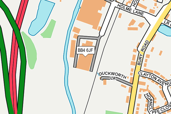
BB4 6JF is located in the Longholme electoral ward, within the local authority district of Rossendale and the English Parliamentary constituency of Rossendale and Darwen. The Sub Integrated Care Board (ICB) Location is NHS Lancashire and South Cumbria ICB - 01A and the police force is Lancashire. This postcode has been in use since January 1980.


GetTheData
Source: OS OpenMap – Local (Ordnance Survey)
Source: OS VectorMap District (Ordnance Survey)
Licence: Open Government Licence (requires attribution)
| Easting | 380112 |
| Northing | 421713 |
| Latitude | 53.691481 |
| Longitude | -2.302650 |
GetTheData
Source: Open Postcode Geo
Licence: Open Government Licence
| Country | England |
| Postcode District | BB4 |
➜ See where BB4 is on a map ➜ Where is Rawtenstall? | |
GetTheData
Source: Land Registry Price Paid Data
Licence: Open Government Licence
Elevation or altitude of BB4 6JF as distance above sea level:
| Metres | Feet | |
|---|---|---|
| Elevation | 160m | 525ft |
Elevation is measured from the approximate centre of the postcode, to the nearest point on an OS contour line from OS Terrain 50, which has contour spacing of ten vertical metres.
➜ How high above sea level am I? Find the elevation of your current position using your device's GPS.
GetTheData
Source: Open Postcode Elevation
Licence: Open Government Licence
| Ward | Longholme |
| Constituency | Rossendale And Darwen |
GetTheData
Source: ONS Postcode Database
Licence: Open Government Licence
| Whitchaff Inn (Holme Lane) | Townsend Fold | 186m |
| Whitchaff Inn (Bury Road) | Townsend Fold | 203m |
| East Lancs Railway (Holme Lane) | Townsend Fold | 225m |
| Lower Clowes Rd (Bury Road) | Townsend Fold | 293m |
| Wood Top (Bury Road) | Wood Top | 494m |
| Rawtenstall (East Lancashire Railway) | Longholme | 1,115m |
GetTheData
Source: NaPTAN
Licence: Open Government Licence
GetTheData
Source: ONS Postcode Database
Licence: Open Government Licence


➜ Get more ratings from the Food Standards Agency
GetTheData
Source: Food Standards Agency
Licence: FSA terms & conditions
| Last Collection | |||
|---|---|---|---|
| Location | Mon-Fri | Sat | Distance |
| Railway Station | 16:45 | 12:30 | 1,179m |
| Sidmouth Avenue | 17:30 | 12:15 | 1,206m |
| Rossendale Delivery Office | 17:45 | 13:00 | 1,676m |
GetTheData
Source: Dracos
Licence: Creative Commons Attribution-ShareAlike
| Risk of BB4 6JF flooding from rivers and sea | Low |
| ➜ BB4 6JF flood map | |
GetTheData
Source: Open Flood Risk by Postcode
Licence: Open Government Licence
The below table lists the International Territorial Level (ITL) codes (formerly Nomenclature of Territorial Units for Statistics (NUTS) codes) and Local Administrative Units (LAU) codes for BB4 6JF:
| ITL 1 Code | Name |
|---|---|
| TLD | North West (England) |
| ITL 2 Code | Name |
| TLD4 | Lancashire |
| ITL 3 Code | Name |
| TLD46 | East Lancashire |
| LAU 1 Code | Name |
| E07000125 | Rossendale |
GetTheData
Source: ONS Postcode Directory
Licence: Open Government Licence
The below table lists the Census Output Area (OA), Lower Layer Super Output Area (LSOA), and Middle Layer Super Output Area (MSOA) for BB4 6JF:
| Code | Name | |
|---|---|---|
| OA | E00128848 | |
| LSOA | E01025384 | Rossendale 008D |
| MSOA | E02005285 | Rossendale 008 |
GetTheData
Source: ONS Postcode Directory
Licence: Open Government Licence
| BB4 6JL | Duckworth Lane | 165m |
| BB4 6JB | Holme Lane | 208m |
| BB4 6JW | Bury Road | 209m |
| BB4 6JH | Holme Terrace | 267m |
| BB4 6JD | Holme Lane | 268m |
| BB4 6EW | Clayton Avenue | 272m |
| BB4 6JQ | The Holme | 295m |
| BB4 6EH | Bury Road | 307m |
| BB4 6EE | Horncliffe Close | 308m |
| BB4 6EL | Lodge Terrace | 342m |
GetTheData
Source: Open Postcode Geo; Land Registry Price Paid Data
Licence: Open Government Licence