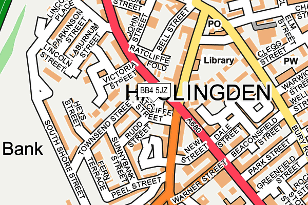
BB4 5JZ is located in the Worsley electoral ward, within the local authority district of Rossendale and the English Parliamentary constituency of Hyndburn. The Sub Integrated Care Board (ICB) Location is NHS Lancashire and South Cumbria ICB - 01A and the police force is Lancashire. This postcode has been in use since September 2008.


GetTheData
Source: OS OpenMap – Local (Ordnance Survey)
Source: OS VectorMap District (Ordnance Survey)
Licence: Open Government Licence (requires attribution)
| Easting | 378541 |
| Northing | 423222 |
| Latitude | 53.704997 |
| Longitude | -2.326544 |
GetTheData
Source: Open Postcode Geo
Licence: Open Government Licence
| Country | England |
| Postcode District | BB4 |
| ➜ BB4 open data dashboard ➜ See where BB4 is on a map ➜ Where is Haslingden? | |
GetTheData
Source: Land Registry Price Paid Data
Licence: Open Government Licence
Elevation or altitude of BB4 5JZ as distance above sea level:
| Metres | Feet | |
|---|---|---|
| Elevation | 240m | 787ft |
Elevation is measured from the approximate centre of the postcode, to the nearest point on an OS contour line from OS Terrain 50, which has contour spacing of ten vertical metres.
➜ How high above sea level am I? Find the elevation of your current position using your device's GPS.
GetTheData
Source: Open Postcode Elevation
Licence: Open Government Licence
| Ward | Worsley |
| Constituency | Hyndburn |
GetTheData
Source: ONS Postcode Database
Licence: Open Government Licence
| January 2024 | Anti-social behaviour | On or near Parking Area | 141m |
| January 2024 | Vehicle crime | On or near Parking Area | 141m |
| January 2024 | Violence and sexual offences | On or near Parking Area | 141m |
| ➜ Get more crime data in our Crime section | |||
GetTheData
Source: data.police.uk
Licence: Open Government Licence
| Dale Street (Manchester Road) | Haslingden | 120m |
| John Street (Blackburn Road) | Haslingden | 154m |
| John Street (Blackburn Road) | Haslingden | 175m |
| Deardengate | Haslingden | 192m |
| Warner Street | Haslingden | 193m |
GetTheData
Source: NaPTAN
Licence: Open Government Licence
GetTheData
Source: ONS Postcode Database
Licence: Open Government Licence


➜ Get more ratings from the Food Standards Agency
GetTheData
Source: Food Standards Agency
Licence: FSA terms & conditions
| Last Collection | |||
|---|---|---|---|
| Location | Mon-Fri | Sat | Distance |
| Haslingden Post Office | 17:15 | 12:00 | 66m |
| Sidmouth Avenue | 17:30 | 12:15 | 973m |
| Railway Station | 16:45 | 12:30 | 2,504m |
GetTheData
Source: Dracos
Licence: Creative Commons Attribution-ShareAlike
| Facility | Distance |
|---|---|
| Body And Fitness (Closed) John Street, Haslingden, Rossendale Health and Fitness Gym | 157m |
| Haslingden St Mary's Fc South Shore Street, Haslingden, Rossendale Grass Pitches | 248m |
| Haslingden Pool (Closed) East Bank Avenue, Haslingden, Rossendale Swimming Pool | 468m |
GetTheData
Source: Active Places
Licence: Open Government Licence
| School | Phase of Education | Distance |
|---|---|---|
| Haslingden St James Church of England Primary School Regent Street, Rossendale, Haslingden, BB4 5HQ | Primary | 290m |
| Haslingden Primary School Ryefield Avenue, Haslingden, Rossendale, BB4 4BJ | Primary | 361m |
| Hillside Nursery School Cedar Avenue, Haslingden, Rossendale, BB4 5NH | Nursery | 729m |
GetTheData
Source: Edubase
Licence: Open Government Licence
The below table lists the International Territorial Level (ITL) codes (formerly Nomenclature of Territorial Units for Statistics (NUTS) codes) and Local Administrative Units (LAU) codes for BB4 5JZ:
| ITL 1 Code | Name |
|---|---|
| TLD | North West (England) |
| ITL 2 Code | Name |
| TLD4 | Lancashire |
| ITL 3 Code | Name |
| TLD46 | East Lancashire |
| LAU 1 Code | Name |
| E07000125 | Rossendale |
GetTheData
Source: ONS Postcode Directory
Licence: Open Government Licence
The below table lists the Census Output Area (OA), Lower Layer Super Output Area (LSOA), and Middle Layer Super Output Area (MSOA) for BB4 5JZ:
| Code | Name | |
|---|---|---|
| OA | E00128893 | |
| LSOA | E01025397 | Rossendale 002F |
| MSOA | E02005279 | Rossendale 002 |
GetTheData
Source: ONS Postcode Directory
Licence: Open Government Licence
| BB4 5DE | Ratcliffe Street | 17m |
| BB4 5QQ | Blackburn Road | 64m |
| BB4 5SX | Deardengate Croft | 67m |
| BB4 5DJ | Thomas Street | 72m |
| BB4 5DG | Rudd Street | 73m |
| BB4 5DF | Townsend Street | 76m |
| BB4 5SN | Deardengate | 85m |
| BB4 5SU | Coal Hey | 87m |
| BB4 5QN | Deardengate | 94m |
| BB4 5DL | Victoria Street | 114m |
GetTheData
Source: Open Postcode Geo; Land Registry Price Paid Data
Licence: Open Government Licence