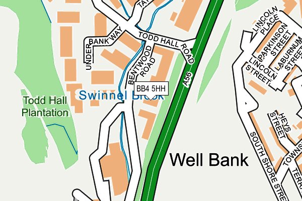
BB4 5HH lies on Bentwood Road in Haslingden, Rossendale. BB4 5HH is located in the Worsley electoral ward, within the local authority district of Rossendale and the English Parliamentary constituency of Hyndburn. The Sub Integrated Care Board (ICB) Location is NHS Lancashire and South Cumbria ICB - 01A and the police force is Lancashire. This postcode has been in use since April 1986.


GetTheData
Source: OS OpenMap – Local (Ordnance Survey)
Source: OS VectorMap District (Ordnance Survey)
Licence: Open Government Licence (requires attribution)
| Easting | 378131 |
| Northing | 423250 |
| Latitude | 53.705216 |
| Longitude | -2.332757 |
GetTheData
Source: Open Postcode Geo
Licence: Open Government Licence
| Street | Bentwood Road |
| Locality | Haslingden |
| Town/City | Rossendale |
| Country | England |
| Postcode District | BB4 |
| ➜ BB4 open data dashboard ➜ See where BB4 is on a map ➜ Where is Haslingden? | |
GetTheData
Source: Land Registry Price Paid Data
Licence: Open Government Licence
Elevation or altitude of BB4 5HH as distance above sea level:
| Metres | Feet | |
|---|---|---|
| Elevation | 200m | 656ft |
Elevation is measured from the approximate centre of the postcode, to the nearest point on an OS contour line from OS Terrain 50, which has contour spacing of ten vertical metres.
➜ How high above sea level am I? Find the elevation of your current position using your device's GPS.
GetTheData
Source: Open Postcode Elevation
Licence: Open Government Licence
| Ward | Worsley |
| Constituency | Hyndburn |
GetTheData
Source: ONS Postcode Database
Licence: Open Government Licence
UNIT 7, BENTWOOD ROAD, HASLINGDEN, ROSSENDALE, BB4 5HH 2004 26 FEB £180,000 |
GetTheData
Source: HM Land Registry Price Paid Data
Licence: Contains HM Land Registry data © Crown copyright and database right 2024. This data is licensed under the Open Government Licence v3.0.
| January 2024 | Drugs | On or near Lincoln Street | 228m |
| December 2023 | Violence and sexual offences | On or near Lincoln Street | 228m |
| August 2023 | Burglary | On or near Lincoln Street | 228m |
| ➜ Bentwood Road crime map and outcomes | |||
GetTheData
Source: data.police.uk
Licence: Open Government Licence
| John Street (Blackburn Road) | Haslingden | 350m |
| John Street (Blackburn Road) | Haslingden | 358m |
| Regent Street (Blackburn Road) | Haslingden | 436m |
| St James Ceps (Blackburn Road) | Haslingden | 457m |
| Deardengate | Haslingden | 519m |
GetTheData
Source: NaPTAN
Licence: Open Government Licence
Estimated total energy consumption in BB4 5HH by fuel type, 2015.
| Consumption (kWh) | 90,368 |
|---|---|
| Meter count | 9 |
| Mean (kWh/meter) | 10,041 |
| Median (kWh/meter) | 1 |
GetTheData
Source: Postcode level gas estimates: 2015 (experimental)
Source: Postcode level electricity estimates: 2015 (experimental)
Licence: Open Government Licence
GetTheData
Source: ONS Postcode Database
Licence: Open Government Licence


➜ Get more ratings from the Food Standards Agency
GetTheData
Source: Food Standards Agency
Licence: FSA terms & conditions
| Last Collection | |||
|---|---|---|---|
| Location | Mon-Fri | Sat | Distance |
| Haslingden Post Office | 17:15 | 12:00 | 464m |
| Sidmouth Avenue | 17:30 | 12:15 | 1,309m |
| Railway Station | 16:45 | 12:30 | 2,908m |
GetTheData
Source: Dracos
Licence: Creative Commons Attribution-ShareAlike
| Facility | Distance |
|---|---|
| Haslingden St Mary's Fc South Shore Street, Haslingden, Rossendale Grass Pitches | 348m |
| Body And Fitness (Closed) John Street, Haslingden, Rossendale Health and Fitness Gym | 405m |
| Perform Centre Ltd (Closed) Waterside Road, Haslingden, Rossendale Health and Fitness Gym | 448m |
GetTheData
Source: Active Places
Licence: Open Government Licence
| School | Phase of Education | Distance |
|---|---|---|
| Haslingden St James Church of England Primary School Regent Street, Rossendale, Haslingden, BB4 5HQ | Primary | 454m |
| Haslingden Primary School Ryefield Avenue, Haslingden, Rossendale, BB4 4BJ | Primary | 675m |
| Austen House Swineherd Farm, Cob Castle Road, Rossendale, BB4 5TS | Not applicable | 722m |
GetTheData
Source: Edubase
Licence: Open Government Licence
The below table lists the International Territorial Level (ITL) codes (formerly Nomenclature of Territorial Units for Statistics (NUTS) codes) and Local Administrative Units (LAU) codes for BB4 5HH:
| ITL 1 Code | Name |
|---|---|
| TLD | North West (England) |
| ITL 2 Code | Name |
| TLD4 | Lancashire |
| ITL 3 Code | Name |
| TLD46 | East Lancashire |
| LAU 1 Code | Name |
| E07000125 | Rossendale |
GetTheData
Source: ONS Postcode Directory
Licence: Open Government Licence
The below table lists the Census Output Area (OA), Lower Layer Super Output Area (LSOA), and Middle Layer Super Output Area (MSOA) for BB4 5HH:
| Code | Name | |
|---|---|---|
| OA | E00128889 | |
| LSOA | E01025397 | Rossendale 002F |
| MSOA | E02005279 | Rossendale 002 |
GetTheData
Source: ONS Postcode Directory
Licence: Open Government Licence
| BB4 5EE | Heys Avenue | 214m |
| BB4 5DX | South Shore Street | 229m |
| BB4 5DT | Lincoln Street | 229m |
| BB4 5LA | Todd Hall Road | 255m |
| BB4 5DS | Lincoln Place | 269m |
| BB4 5DR | Parkinson Street | 275m |
| BB4 5DU | Heys Street | 277m |
| BB4 5DW | Laburnum Street | 293m |
| BB4 5BE | Parkinson Street | 295m |
| BB4 5DL | Victoria Street | 312m |
GetTheData
Source: Open Postcode Geo; Land Registry Price Paid Data
Licence: Open Government Licence