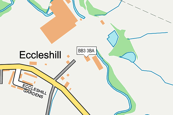
BB3 3BA is located in the West Pennine electoral ward, within the unitary authority of Blackburn with Darwen and the English Parliamentary constituency of Rossendale and Darwen. The Sub Integrated Care Board (ICB) Location is NHS Lancashire and South Cumbria ICB - 00Q and the police force is Lancashire. This postcode has been in use since February 2005.


GetTheData
Source: OS OpenMap – Local (Ordnance Survey)
Source: OS VectorMap District (Ordnance Survey)
Licence: Open Government Licence (requires attribution)
| Easting | 370738 |
| Northing | 424078 |
| Latitude | 53.712294 |
| Longitude | -2.444825 |
GetTheData
Source: Open Postcode Geo
Licence: Open Government Licence
| Country | England |
| Postcode District | BB3 |
➜ See where BB3 is on a map ➜ Where is Eccleshill? | |
GetTheData
Source: Land Registry Price Paid Data
Licence: Open Government Licence
Elevation or altitude of BB3 3BA as distance above sea level:
| Metres | Feet | |
|---|---|---|
| Elevation | 150m | 492ft |
Elevation is measured from the approximate centre of the postcode, to the nearest point on an OS contour line from OS Terrain 50, which has contour spacing of ten vertical metres.
➜ How high above sea level am I? Find the elevation of your current position using your device's GPS.
GetTheData
Source: Open Postcode Elevation
Licence: Open Government Licence
| Ward | West Pennine |
| Constituency | Rossendale And Darwen |
GetTheData
Source: ONS Postcode Database
Licence: Open Government Licence
| Eccleshill Gardens (Johnson Road) | Blackburn | 162m |
| Eccleshill Gardens (Johnson Road) | Blackburn | 187m |
| Victoria Gardens (Johnson New Road) | Waterside | 1,029m |
| Punch Bowl (Roman Road) | Eccleshill | 1,110m |
| Lower Fold (Belthorn Road) | Belthorn | 1,128m |
| Darwen Station | 2.1km |
| Blackburn Station | 4.4km |
| Mill Hill (Lancs) Station | 4.6km |
GetTheData
Source: NaPTAN
Licence: Open Government Licence
GetTheData
Source: ONS Postcode Database
Licence: Open Government Licence


➜ Get more ratings from the Food Standards Agency
GetTheData
Source: Food Standards Agency
Licence: FSA terms & conditions
| Last Collection | |||
|---|---|---|---|
| Location | Mon-Fri | Sat | Distance |
| 68 Birch Hall Avenue | 16:30 | 11:00 | 2,425m |
| Old Bank Lane | 16:15 | 11:00 | 3,037m |
| Longton Street | 17:15 | 13:15 | 3,895m |
GetTheData
Source: Dracos
Licence: Creative Commons Attribution-ShareAlike
| Risk of BB3 3BA flooding from rivers and sea | Medium |
| ➜ BB3 3BA flood map | |
GetTheData
Source: Open Flood Risk by Postcode
Licence: Open Government Licence
The below table lists the International Territorial Level (ITL) codes (formerly Nomenclature of Territorial Units for Statistics (NUTS) codes) and Local Administrative Units (LAU) codes for BB3 3BA:
| ITL 1 Code | Name |
|---|---|
| TLD | North West (England) |
| ITL 2 Code | Name |
| TLD4 | Lancashire |
| ITL 3 Code | Name |
| TLD41 | Blackburn with Darwen |
| LAU 1 Code | Name |
| E06000008 | Blackburn with Darwen |
GetTheData
Source: ONS Postcode Directory
Licence: Open Government Licence
The below table lists the Census Output Area (OA), Lower Layer Super Output Area (LSOA), and Middle Layer Super Output Area (MSOA) for BB3 3BA:
| Code | Name | |
|---|---|---|
| OA | E00063488 | |
| LSOA | E01012592 | Blackburn with Darwen 018A |
| MSOA | E02002632 | Blackburn with Darwen 018 |
GetTheData
Source: ONS Postcode Directory
Licence: Open Government Licence
| BB3 3PE | Johnson Road | 112m |
| BB3 3PQ | Eccleshill Gardens | 239m |
| BB3 3NZ | Barnes Holme | 790m |
| BB3 3PL | Eccleshill Cottages | 817m |
| BB3 3PJ | Roman Road | 825m |
| BB1 2NP | Woodhead | 839m |
| BB3 3PB | Lower Waterside | 925m |
| BB3 3PA | Victoria Buildings | 928m |
| BB3 3PD | Waterside Terrace | 966m |
| BB1 2NL | Belthorn Road | 1030m |
GetTheData
Source: Open Postcode Geo; Land Registry Price Paid Data
Licence: Open Government Licence