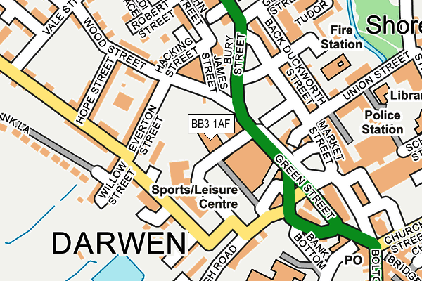
BB3 1AF lies on Police Street in Darwen. BB3 1AF is located in the Darwen West electoral ward, within the unitary authority of Blackburn with Darwen and the English Parliamentary constituency of Rossendale and Darwen. The Sub Integrated Care Board (ICB) Location is NHS Lancashire and South Cumbria ICB - 00Q and the police force is Lancashire. This postcode has been in use since September 2014.


GetTheData
Source: OS OpenMap – Local (Ordnance Survey)
Source: OS VectorMap District (Ordnance Survey)
Licence: Open Government Licence (requires attribution)
| Easting | 369012 |
| Northing | 422319 |
| Latitude | 53.696385 |
| Longitude | -2.470798 |
GetTheData
Source: Open Postcode Geo
Licence: Open Government Licence
| Street | Police Street |
| Town/City | Darwen |
| Country | England |
| Postcode District | BB3 |
| ➜ BB3 open data dashboard ➜ See where BB3 is on a map ➜ Where is Darwen? | |
GetTheData
Source: Land Registry Price Paid Data
Licence: Open Government Licence
Elevation or altitude of BB3 1AF as distance above sea level:
| Metres | Feet | |
|---|---|---|
| Elevation | 160m | 525ft |
Elevation is measured from the approximate centre of the postcode, to the nearest point on an OS contour line from OS Terrain 50, which has contour spacing of ten vertical metres.
➜ How high above sea level am I? Find the elevation of your current position using your device's GPS.
GetTheData
Source: Open Postcode Elevation
Licence: Open Government Licence
| Ward | Darwen West |
| Constituency | Rossendale And Darwen |
GetTheData
Source: ONS Postcode Database
Licence: Open Government Licence
| January 2024 | Shoplifting | On or near Buff Street | 366m |
| January 2024 | Shoplifting | On or near Buff Street | 366m |
| January 2024 | Shoplifting | On or near Buff Street | 366m |
| ➜ Get more crime data in our Crime section | |||
GetTheData
Source: data.police.uk
Licence: Open Government Licence
| Health Centre (Police Street) | Darwen | 74m |
| Hacking Street (Bury Street) | Darwen | 134m |
| Duckworth Street (Market Street) | Darwen | 142m |
| Circus (Market Street) | Darwen | 197m |
| Town Centre (Croft Street) | Darwen | 209m |
| Darwen Station | 0.4km |
| Mill Hill (Lancs) Station | 4.8km |
| Cherry Tree Station | 5.1km |
GetTheData
Source: NaPTAN
Licence: Open Government Licence
GetTheData
Source: ONS Postcode Database
Licence: Open Government Licence


➜ Get more ratings from the Food Standards Agency
GetTheData
Source: Food Standards Agency
Licence: FSA terms & conditions
| Last Collection | |||
|---|---|---|---|
| Location | Mon-Fri | Sat | Distance |
| 68 Birch Hall Avenue | 16:30 | 11:00 | 346m |
| Royal Arms | 12:00 | 09:00 | 2,631m |
| Moorgate | 16:15 | 11:15 | 4,064m |
GetTheData
Source: Dracos
Licence: Creative Commons Attribution-ShareAlike
| Facility | Distance |
|---|---|
| Darwen Leisure Centre (Closed) Green Street, Darwen Sports Hall, Swimming Pool, Health and Fitness Gym, Squash Courts | 57m |
| Darwen Leisure Centre The Green, Darwen Swimming Pool, Health and Fitness Gym, Sports Hall, Studio | 65m |
| Holy Trinity Ce Primary School Bank Top, Darwen Artificial Grass Pitch | 221m |
GetTheData
Source: Active Places
Licence: Open Government Licence
| School | Phase of Education | Distance |
|---|---|---|
| Darwen Aldridge Enterprise Studio Police Street, Darwen, BB3 1AF | Secondary | 0m |
| Holy Trinity VC School Bank Top, Darwen, BB3 2RW | Primary | 194m |
| Darwen Aldridge Community Academy Sudell Road, Darwen, BB3 3HD | Secondary | 573m |
GetTheData
Source: Edubase
Licence: Open Government Licence
The below table lists the International Territorial Level (ITL) codes (formerly Nomenclature of Territorial Units for Statistics (NUTS) codes) and Local Administrative Units (LAU) codes for BB3 1AF:
| ITL 1 Code | Name |
|---|---|
| TLD | North West (England) |
| ITL 2 Code | Name |
| TLD4 | Lancashire |
| ITL 3 Code | Name |
| TLD41 | Blackburn with Darwen |
| LAU 1 Code | Name |
| E06000008 | Blackburn with Darwen |
GetTheData
Source: ONS Postcode Directory
Licence: Open Government Licence
The below table lists the Census Output Area (OA), Lower Layer Super Output Area (LSOA), and Middle Layer Super Output Area (MSOA) for BB3 1AF:
| Code | Name | |
|---|---|---|
| OA | E00063770 | |
| LSOA | E01012653 | Blackburn with Darwen 016C |
| MSOA | E02002630 | Blackburn with Darwen 016 |
GetTheData
Source: ONS Postcode Directory
Licence: Open Government Licence
| BB3 1AP | Prince Street | 83m |
| BB3 1AW | Everton Street | 109m |
| BB3 1PU | Wellington Fold | 123m |
| BB3 1LG | Weavers Row | 127m |
| BB3 1LU | Weavers Mews | 129m |
| BB3 1AU | Duckworth Street | 145m |
| BB3 1LS | Wood Street | 154m |
| BB3 0DA | Union Street | 162m |
| BB3 1LQ | Reservoir Street | 165m |
| BB3 1LH | Willow Street | 167m |
GetTheData
Source: Open Postcode Geo; Land Registry Price Paid Data
Licence: Open Government Licence