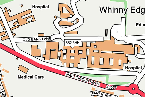
BB2 3HH is located in the Blackburn South East electoral ward, within the unitary authority of Blackburn with Darwen and the English Parliamentary constituency of Blackburn. The Sub Integrated Care Board (ICB) Location is NHS Lancashire and South Cumbria ICB - 00Q and the police force is Lancashire. This postcode has been in use since January 1980.


GetTheData
Source: OS OpenMap – Local (Ordnance Survey)
Source: OS VectorMap District (Ordnance Survey)
Licence: Open Government Licence (requires attribution)
| Easting | 369574 |
| Northing | 426674 |
| Latitude | 53.735560 |
| Longitude | -2.462716 |
GetTheData
Source: Open Postcode Geo
Licence: Open Government Licence
| Country | England |
| Postcode District | BB2 |
| ➜ BB2 open data dashboard ➜ See where BB2 is on a map ➜ Where is Blackburn? | |
GetTheData
Source: Land Registry Price Paid Data
Licence: Open Government Licence
Elevation or altitude of BB2 3HH as distance above sea level:
| Metres | Feet | |
|---|---|---|
| Elevation | 200m | 656ft |
Elevation is measured from the approximate centre of the postcode, to the nearest point on an OS contour line from OS Terrain 50, which has contour spacing of ten vertical metres.
➜ How high above sea level am I? Find the elevation of your current position using your device's GPS.
GetTheData
Source: Open Postcode Elevation
Licence: Open Government Licence
| Ward | Blackburn South East |
| Constituency | Blackburn |
GetTheData
Source: ONS Postcode Database
Licence: Open Government Licence
| June 2023 | Anti-social behaviour | On or near Delius Close | 412m |
| June 2023 | Anti-social behaviour | On or near Delius Close | 412m |
| April 2023 | Vehicle crime | On or near Delius Close | 412m |
| ➜ Get more crime data in our Crime section | |||
GetTheData
Source: data.police.uk
Licence: Open Government Licence
| Haslingden Road | Royal Blackburn Hospital | 121m |
| Haslingden Road | Royal Blackburn Hospital | 129m |
| Royal Blackburn Hospital (Hospital Inner Road) | Royal Blackburn Hospital | 194m |
| Royal Blackburn Hospital (Hospital Inner Road) | Royal Blackburn Hospital | 199m |
| Hospital Drive (Haslingden Road) | Guide | 235m |
| Blackburn Station | 1.6km |
| Mill Hill (Lancs) Station | 2.6km |
| Cherry Tree Station | 3.7km |
GetTheData
Source: NaPTAN
Licence: Open Government Licence
GetTheData
Source: ONS Postcode Database
Licence: Open Government Licence


➜ Get more ratings from the Food Standards Agency
GetTheData
Source: Food Standards Agency
Licence: FSA terms & conditions
| Last Collection | |||
|---|---|---|---|
| Location | Mon-Fri | Sat | Distance |
| Old Bank Lane | 16:15 | 11:00 | 390m |
| Longton Street | 17:15 | 13:15 | 1,391m |
| Railway Station | 16:30 | 12:15 | 1,661m |
GetTheData
Source: Dracos
Licence: Creative Commons Attribution-ShareAlike
| Facility | Distance |
|---|---|
| Blackburn Central High School With Crosshill Haslingden Road, Blackburn Health and Fitness Gym, Sports Hall, Artificial Grass Pitch, Studio, Grass Pitches | 477m |
| Blackburn Golf Centre And Driving Range (Closed) Haslingden Road, Blackburn Golf | 490m |
| Newfield School Old Bank Lane, Blackburn Sports Hall, Swimming Pool | 493m |
GetTheData
Source: Active Places
Licence: Open Government Licence
| School | Phase of Education | Distance |
|---|---|---|
| Newfield School Old Bank Lane, Off Shadsworth Road, Blackburn, BB1 2PW | Not applicable | 491m |
| Blackburn Central High School Haslingden Road, Blackburn, BB2 3HJ | Secondary | 598m |
| Audley Junior School Queen's Park Road, Blackburn, BB1 1SE | Primary | 688m |
GetTheData
Source: Edubase
Licence: Open Government Licence
The below table lists the International Territorial Level (ITL) codes (formerly Nomenclature of Territorial Units for Statistics (NUTS) codes) and Local Administrative Units (LAU) codes for BB2 3HH:
| ITL 1 Code | Name |
|---|---|
| TLD | North West (England) |
| ITL 2 Code | Name |
| TLD4 | Lancashire |
| ITL 3 Code | Name |
| TLD41 | Blackburn with Darwen |
| LAU 1 Code | Name |
| E06000008 | Blackburn with Darwen |
GetTheData
Source: ONS Postcode Directory
Licence: Open Government Licence
The below table lists the Census Output Area (OA), Lower Layer Super Output Area (LSOA), and Middle Layer Super Output Area (MSOA) for BB2 3HH:
| Code | Name | |
|---|---|---|
| OA | E00171893 | |
| LSOA | E01012632 | Blackburn with Darwen 011F |
| MSOA | E02002625 | Blackburn with Darwen 011 |
GetTheData
Source: ONS Postcode Directory
Licence: Open Government Licence
| BB1 2RB | Pankhurst Close | 216m |
| BB1 2RE | Nightingale Close | 281m |
| BB1 2RD | Beale Close | 307m |
| BB2 3TD | Britten Close | 318m |
| BB1 2RA | Seacole Close | 325m |
| BB2 3TQ | Walton Crescent | 380m |
| BB1 2ND | Haslingden Road | 385m |
| BB2 3WS | Delius Close | 399m |
| BB2 3TF | Sullivan Drive | 411m |
| BB2 3TE | Elgar Close | 417m |
GetTheData
Source: Open Postcode Geo; Land Registry Price Paid Data
Licence: Open Government Licence