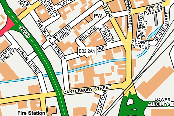
BB2 2AN is located in the Blackburn Central electoral ward, within the unitary authority of Blackburn with Darwen and the English Parliamentary constituency of Blackburn. The Sub Integrated Care Board (ICB) Location is NHS Lancashire and South Cumbria ICB - 00Q and the police force is Lancashire. This postcode has been in use since January 1980.


GetTheData
Source: OS OpenMap – Local (Ordnance Survey)
Source: OS VectorMap District (Ordnance Survey)
Licence: Open Government Licence (requires attribution)
| Easting | 368124 |
| Northing | 427694 |
| Latitude | 53.744655 |
| Longitude | -2.484800 |
GetTheData
Source: Open Postcode Geo
Licence: Open Government Licence
| Country | England |
| Postcode District | BB2 |
| ➜ BB2 open data dashboard ➜ See where BB2 is on a map ➜ Where is Blackburn? | |
GetTheData
Source: Land Registry Price Paid Data
Licence: Open Government Licence
Elevation or altitude of BB2 2AN as distance above sea level:
| Metres | Feet | |
|---|---|---|
| Elevation | 110m | 361ft |
Elevation is measured from the approximate centre of the postcode, to the nearest point on an OS contour line from OS Terrain 50, which has contour spacing of ten vertical metres.
➜ How high above sea level am I? Find the elevation of your current position using your device's GPS.
GetTheData
Source: Open Postcode Elevation
Licence: Open Government Licence
| Ward | Blackburn Central |
| Constituency | Blackburn |
GetTheData
Source: ONS Postcode Database
Licence: Open Government Licence
| January 2024 | Anti-social behaviour | On or near Sumner Street | 255m |
| January 2024 | Violence and sexual offences | On or near Sumner Street | 255m |
| January 2024 | Violence and sexual offences | On or near Sumner Street | 255m |
| ➜ Get more crime data in our Crime section | |||
GetTheData
Source: data.police.uk
Licence: Open Government Licence
| St Peters Street (Freckleton Street) | Blackburn Town Centre | 142m |
| Darwen Street | Blackburn Town Centre | 153m |
| Mincing Lane (Darwen Street) | Blackburn Town Centre | 206m |
| Darwen Street | Blackburn Town Centre | 206m |
| Montague Street (King Street) | Blackburn | 323m |
| Blackburn Station | 0.4km |
| Mill Hill (Lancs) Station | 1.5km |
| Cherry Tree Station | 2.6km |
GetTheData
Source: NaPTAN
Licence: Open Government Licence
| Median download speed | 19.0Mbps |
| Average download speed | 41.9Mbps |
| Maximum download speed | 80.00Mbps |
| Median upload speed | 5.8Mbps |
| Average upload speed | 9.7Mbps |
| Maximum upload speed | 20.00Mbps |
GetTheData
Source: Ofcom
Licence: Ofcom Terms of Use (requires attribution)
GetTheData
Source: ONS Postcode Database
Licence: Open Government Licence

➜ Get more ratings from the Food Standards Agency
GetTheData
Source: Food Standards Agency
Licence: FSA terms & conditions
| Last Collection | |||
|---|---|---|---|
| Location | Mon-Fri | Sat | Distance |
| Blackburn Delivery Office | 18:30 | 13:00 | 116m |
| Dukes Brow | 16:30 | 12:00 | 217m |
| Blackburn Cathedral | 16:30 | 13:00 | 314m |
GetTheData
Source: Dracos
Licence: Creative Commons Attribution-ShareAlike
| Facility | Distance |
|---|---|
| West End Youth And Community Centre (Closed) Clayton Street, Blackburn Sports Hall | 227m |
| Blackburn Youth Zone Jubilee Street, Blackburn Sports Hall, Health and Fitness Gym, Studio, Artificial Grass Pitch | 237m |
| Planet Ice Blackburn Arena Grimshaw Retail Park, Blackburn Ice Rinks | 345m |
GetTheData
Source: Active Places
Licence: Open Government Licence
| School | Phase of Education | Distance |
|---|---|---|
| St Anne's Roman Catholic Primary School Blackburn Feilden Street, Blackburn, BB2 1LQ | Primary | 355m |
| Tauheedul Islam Boys' High School Sumner Street, Blackburn, BB2 2LD | Secondary | 385m |
| Blackburn College Blackburn College, Harrison Centre, Feilden Street, Blackburn, BB2 1LH | 16 plus | 490m |
GetTheData
Source: Edubase
Licence: Open Government Licence
The below table lists the International Territorial Level (ITL) codes (formerly Nomenclature of Territorial Units for Statistics (NUTS) codes) and Local Administrative Units (LAU) codes for BB2 2AN:
| ITL 1 Code | Name |
|---|---|
| TLD | North West (England) |
| ITL 2 Code | Name |
| TLD4 | Lancashire |
| ITL 3 Code | Name |
| TLD41 | Blackburn with Darwen |
| LAU 1 Code | Name |
| E06000008 | Blackburn with Darwen |
GetTheData
Source: ONS Postcode Directory
Licence: Open Government Licence
The below table lists the Census Output Area (OA), Lower Layer Super Output Area (LSOA), and Middle Layer Super Output Area (MSOA) for BB2 2AN:
| Code | Name | |
|---|---|---|
| OA | E00063805 | |
| LSOA | E01012655 | Blackburn with Darwen 006E |
| MSOA | E02002620 | Blackburn with Darwen 006 |
GetTheData
Source: ONS Postcode Directory
Licence: Open Government Licence
| BB2 2AA | Mill Lane | 80m |
| BB2 2HH | St Peter Street | 109m |
| BB2 2HP | Canterbury Street | 112m |
| BB2 2AU | Mill Lane | 137m |
| BB2 2HD | St Peter Street | 140m |
| BB2 2HL | St Peter Street | 148m |
| BB2 2AJ | Darwen Street | 148m |
| BB2 2AD | Mincing Lane | 154m |
| BB2 2HN | Byrom Street | 172m |
| BB2 2AQ | Darwen Street | 184m |
GetTheData
Source: Open Postcode Geo; Land Registry Price Paid Data
Licence: Open Government Licence