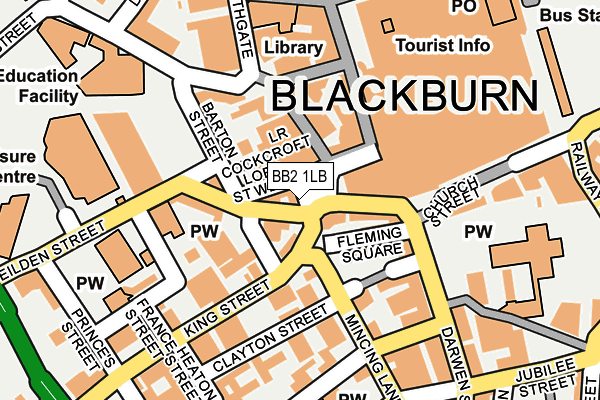
BB2 1LB is located in the Blackburn Central electoral ward, within the unitary authority of Blackburn with Darwen and the English Parliamentary constituency of Blackburn. The Sub Integrated Care Board (ICB) Location is NHS Lancashire and South Cumbria ICB - 00Q and the police force is Lancashire. This postcode has been in use since January 1980.


GetTheData
Source: OS OpenMap – Local (Ordnance Survey)
Source: OS VectorMap District (Ordnance Survey)
Licence: Open Government Licence (requires attribution)
| Easting | 368126 |
| Northing | 428039 |
| Latitude | 53.747741 |
| Longitude | -2.484807 |
GetTheData
Source: Open Postcode Geo
Licence: Open Government Licence
| Country | England |
| Postcode District | BB2 |
| ➜ BB2 open data dashboard ➜ See where BB2 is on a map ➜ Where is Blackburn? | |
GetTheData
Source: Land Registry Price Paid Data
Licence: Open Government Licence
Elevation or altitude of BB2 1LB as distance above sea level:
| Metres | Feet | |
|---|---|---|
| Elevation | 110m | 361ft |
Elevation is measured from the approximate centre of the postcode, to the nearest point on an OS contour line from OS Terrain 50, which has contour spacing of ten vertical metres.
➜ How high above sea level am I? Find the elevation of your current position using your device's GPS.
GetTheData
Source: Open Postcode Elevation
Licence: Open Government Licence
| Ward | Blackburn Central |
| Constituency | Blackburn |
GetTheData
Source: ONS Postcode Database
Licence: Open Government Licence
| January 2024 | Anti-social behaviour | On or near Parking Area | 282m |
| January 2024 | Anti-social behaviour | On or near Parking Area | 282m |
| January 2024 | Anti-social behaviour | On or near Parking Area | 282m |
| ➜ Get more crime data in our Crime section | |||
GetTheData
Source: data.police.uk
Licence: Open Government Licence
| Debenhams (Astley Gate) | Blackburn Town Centre | 59m |
| Barton Street | Blackburn | 106m |
| Barton Street | Blackburn | 129m |
| Blakey Moor | Blackburn | 226m |
| Mincing Lane (Darwen Street) | Blackburn Town Centre | 229m |
| Blackburn Station | 0.4km |
| Mill Hill (Lancs) Station | 1.8km |
| Cherry Tree Station | 2.8km |
GetTheData
Source: NaPTAN
Licence: Open Government Licence
GetTheData
Source: ONS Postcode Database
Licence: Open Government Licence


➜ Get more ratings from the Food Standards Agency
GetTheData
Source: Food Standards Agency
Licence: FSA terms & conditions
| Last Collection | |||
|---|---|---|---|
| Location | Mon-Fri | Sat | Distance |
| Technical College | 16:00 | 11:15 | 125m |
| Blackburn Cathedral | 16:30 | 13:00 | 149m |
| Church Street | 16:30 | 13:00 | 217m |
GetTheData
Source: Dracos
Licence: Creative Commons Attribution-ShareAlike
| Facility | Distance |
|---|---|
| West End Youth And Community Centre (Closed) Clayton Street, Blackburn Sports Hall | 120m |
| Total Shape (Closed) King William Street, Blackburn Studio, Health and Fitness Gym | 144m |
| Waves Water Fun Centre (Closed) Nab Lane, Blackburn Swimming Pool, Health and Fitness Gym, Studio | 175m |
GetTheData
Source: Active Places
Licence: Open Government Licence
| School | Phase of Education | Distance |
|---|---|---|
| St Anne's Roman Catholic Primary School Blackburn Feilden Street, Blackburn, BB2 1LQ | Primary | 137m |
| Blackburn College Blackburn College, Harrison Centre, Feilden Street, Blackburn, BB2 1LH | 16 plus | 309m |
| St Michael With St John CofE Primary School Swallow Drive, Blackburn, BB1 6LE | Primary | 603m |
GetTheData
Source: Edubase
Licence: Open Government Licence
The below table lists the International Territorial Level (ITL) codes (formerly Nomenclature of Territorial Units for Statistics (NUTS) codes) and Local Administrative Units (LAU) codes for BB2 1LB:
| ITL 1 Code | Name |
|---|---|
| TLD | North West (England) |
| ITL 2 Code | Name |
| TLD4 | Lancashire |
| ITL 3 Code | Name |
| TLD41 | Blackburn with Darwen |
| LAU 1 Code | Name |
| E06000008 | Blackburn with Darwen |
GetTheData
Source: ONS Postcode Directory
Licence: Open Government Licence
The below table lists the Census Output Area (OA), Lower Layer Super Output Area (LSOA), and Middle Layer Super Output Area (MSOA) for BB2 1LB:
| Code | Name | |
|---|---|---|
| OA | E00063797 | |
| LSOA | E01012655 | Blackburn with Darwen 006E |
| MSOA | E02002620 | Blackburn with Darwen 006 |
GetTheData
Source: ONS Postcode Directory
Licence: Open Government Licence
| BB2 1JX | Lord Street West | 35m |
| BB2 1JD | Lower Cockcroft | 66m |
| BB2 1JG | Higher Church Street | 66m |
| BB2 1JU | Northgate | 71m |
| BB2 2DG | Fleming Square | 81m |
| BB2 1JL | Northgate | 84m |
| BB2 1LG | Cardwell Place | 94m |
| BB2 2EB | Mincing Lane | 119m |
| BB2 2ED | Clayton Street | 120m |
| BB1 5AF | Church Street | 141m |
GetTheData
Source: Open Postcode Geo; Land Registry Price Paid Data
Licence: Open Government Licence