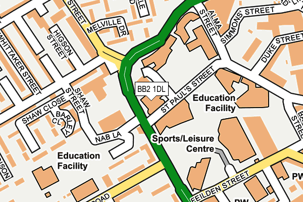
BB2 1DL is located in the Blackburn Central electoral ward, within the unitary authority of Blackburn with Darwen and the English Parliamentary constituency of Blackburn. The Sub Integrated Care Board (ICB) Location is NHS Lancashire and South Cumbria ICB - 00Q and the police force is Lancashire. This postcode has been in use since December 1996.


GetTheData
Source: OS OpenMap – Local (Ordnance Survey)
Source: OS VectorMap District (Ordnance Survey)
Licence: Open Government Licence (requires attribution)
| Easting | 367738 |
| Northing | 428157 |
| Latitude | 53.748778 |
| Longitude | -2.490703 |
GetTheData
Source: Open Postcode Geo
Licence: Open Government Licence
| Country | England |
| Postcode District | BB2 |
| ➜ BB2 open data dashboard ➜ See where BB2 is on a map ➜ Where is Blackburn? | |
GetTheData
Source: Land Registry Price Paid Data
Licence: Open Government Licence
Elevation or altitude of BB2 1DL as distance above sea level:
| Metres | Feet | |
|---|---|---|
| Elevation | 110m | 361ft |
Elevation is measured from the approximate centre of the postcode, to the nearest point on an OS contour line from OS Terrain 50, which has contour spacing of ten vertical metres.
➜ How high above sea level am I? Find the elevation of your current position using your device's GPS.
GetTheData
Source: Open Postcode Elevation
Licence: Open Government Licence
| Ward | Blackburn Central |
| Constituency | Blackburn |
GetTheData
Source: ONS Postcode Database
Licence: Open Government Licence
| January 2024 | Violence and sexual offences | On or near Roney Street | 309m |
| January 2024 | Anti-social behaviour | On or near Petrol Station | 358m |
| January 2024 | Anti-social behaviour | On or near Petrol Station | 358m |
| ➜ Get more crime data in our Crime section | |||
GetTheData
Source: data.police.uk
Licence: Open Government Licence
| Blackburn College (St Paul's Street) | Blackburn | 78m |
| Blackburn College (Fielden Street) | Blackburn | 100m |
| Higson Street (Johnston Street) | Blackburn | 162m |
| Higson Street (Johnston Street) | Blackburn | 173m |
| Alma Street (Blakey Moor) | Blackburn Town Centre | 179m |
| Blackburn Station | 0.8km |
| Mill Hill (Lancs) Station | 1.7km |
| Cherry Tree Station | 2.5km |
GetTheData
Source: NaPTAN
Licence: Open Government Licence
GetTheData
Source: ONS Postcode Database
Licence: Open Government Licence


➜ Get more ratings from the Food Standards Agency
GetTheData
Source: Food Standards Agency
Licence: FSA terms & conditions
| Last Collection | |||
|---|---|---|---|
| Location | Mon-Fri | Sat | Distance |
| Technical College | 16:00 | 11:15 | 336m |
| 91 Preston New Road | 17:15 | 13:00 | 377m |
| Dukes Brow | 16:30 | 12:00 | 387m |
GetTheData
Source: Dracos
Licence: Creative Commons Attribution-ShareAlike
| Facility | Distance |
|---|---|
| Blackburn College (Closed) Feilden Street, Blackburn Health and Fitness Gym, Sports Hall, Studio | 113m |
| Blackburn Sports Leisure Centre Feilden Street, Blackburn Swimming Pool, Health and Fitness Gym, Studio, Sports Hall | 171m |
| Waves Water Fun Centre (Closed) Nab Lane, Blackburn Swimming Pool, Health and Fitness Gym, Studio | 235m |
GetTheData
Source: Active Places
Licence: Open Government Licence
| School | Phase of Education | Distance |
|---|---|---|
| Blackburn College Blackburn College, Harrison Centre, Feilden Street, Blackburn, BB2 1LH | 16 plus | 113m |
| St Barnabas and St Paul's Church of England Voluntary Aided Primary School Oakenhurst Road, Blackburn, BB2 1SN | Primary | 271m |
| St Anne's Roman Catholic Primary School Blackburn Feilden Street, Blackburn, BB2 1LQ | Primary | 285m |
GetTheData
Source: Edubase
Licence: Open Government Licence
The below table lists the International Territorial Level (ITL) codes (formerly Nomenclature of Territorial Units for Statistics (NUTS) codes) and Local Administrative Units (LAU) codes for BB2 1DL:
| ITL 1 Code | Name |
|---|---|
| TLD | North West (England) |
| ITL 2 Code | Name |
| TLD4 | Lancashire |
| ITL 3 Code | Name |
| TLD41 | Blackburn with Darwen |
| LAU 1 Code | Name |
| E06000008 | Blackburn with Darwen |
GetTheData
Source: ONS Postcode Directory
Licence: Open Government Licence
The below table lists the Census Output Area (OA), Lower Layer Super Output Area (LSOA), and Middle Layer Super Output Area (MSOA) for BB2 1DL:
| Code | Name | |
|---|---|---|
| OA | E00063793 | |
| LSOA | E01012656 | Blackburn with Darwen 005C |
| MSOA | E02002619 | Blackburn with Darwen 005 |
GetTheData
Source: ONS Postcode Directory
Licence: Open Government Licence
| BB2 1NE | Montague Street | 116m |
| BB2 1SR | Heyhurst Road | 123m |
| BB2 1QZ | Cowell Way | 158m |
| BB2 1DN | University Close | 167m |
| BB2 1ES | Johnston Street | 168m |
| BB2 1SP | Oakenhurst Road | 173m |
| BB2 1EH | Montague Street | 177m |
| BB2 1RD | 184m | |
| BB2 1DE | Melville Drive | 193m |
| BB2 1DG | Denville Road | 198m |
GetTheData
Source: Open Postcode Geo; Land Registry Price Paid Data
Licence: Open Government Licence