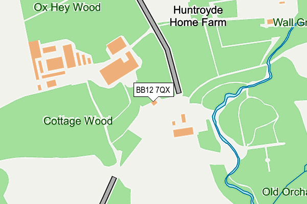
BB12 7QX is located in the East Whalley, Read & Simonstone electoral ward, within the local authority district of Ribble Valley and the English Parliamentary constituency of Ribble Valley. The Sub Integrated Care Board (ICB) Location is NHS Lancashire and South Cumbria ICB - 01A and the police force is Lancashire. This postcode has been in use since January 1980.


GetTheData
Source: OS OpenMap – Local (Ordnance Survey)
Source: OS VectorMap District (Ordnance Survey)
Licence: Open Government Licence (requires attribution)
| Easting | 378554 |
| Northing | 435202 |
| Latitude | 53.812656 |
| Longitude | -2.327184 |
GetTheData
Source: Open Postcode Geo
Licence: Open Government Licence
| Country | England |
| Postcode District | BB12 |
| ➜ BB12 open data dashboard ➜ See where BB12 is on a map | |
GetTheData
Source: Land Registry Price Paid Data
Licence: Open Government Licence
Elevation or altitude of BB12 7QX as distance above sea level:
| Metres | Feet | |
|---|---|---|
| Elevation | 130m | 427ft |
Elevation is measured from the approximate centre of the postcode, to the nearest point on an OS contour line from OS Terrain 50, which has contour spacing of ten vertical metres.
➜ How high above sea level am I? Find the elevation of your current position using your device's GPS.
GetTheData
Source: Open Postcode Elevation
Licence: Open Government Licence
| Ward | East Whalley, Read & Simonstone |
| Constituency | Ribble Valley |
GetTheData
Source: ONS Postcode Database
Licence: Open Government Licence
| Higham Road | Clay Bank | 752m |
| Pennine Grove | Clay Bank | 769m |
| Slade Lane (Moor Lane) | Padiham | 1,114m |
| The Grove (Hargrove Avenue) | Padiham | 1,129m |
| Slade Lane (Moor Lane) | Padiham | 1,129m |
| Hapton Station | 3.5km |
| Rose Grove Station | 4.1km |
| Huncoat Station | 4.7km |
GetTheData
Source: NaPTAN
Licence: Open Government Licence
GetTheData
Source: ONS Postcode Database
Licence: Open Government Licence


➜ Get more ratings from the Food Standards Agency
GetTheData
Source: Food Standards Agency
Licence: FSA terms & conditions
| Last Collection | |||
|---|---|---|---|
| Location | Mon-Fri | Sat | Distance |
| Padiham Post Office | 18:00 | 11:00 | 1,525m |
| Burnley Road | 17:30 | 11:00 | 1,533m |
| Laneside | 16:00 | 10:00 | 2,288m |
GetTheData
Source: Dracos
Licence: Creative Commons Attribution-ShareAlike
| Facility | Distance |
|---|---|
| Higham Recreation Ground (Closed) Higham Road, Padiham, Burnley Grass Pitches | 943m |
| Padiham St Leonards C Of E School Meadow Street, Padiham Grass Pitches | 1.2km |
| The Arbories Memorial Sports Ground - Padiham Sports Club Well Street, Padiham, Burnley Grass Pitches | 1.3km |
GetTheData
Source: Active Places
Licence: Open Government Licence
| School | Phase of Education | Distance |
|---|---|---|
| Padiham St Leonard's Voluntary Aided Church of England Primary School Moor Lane, Padiham, Padiham St Leonard's Ce Va Primary, Padiham, Burnley, BB12 8HT | Primary | 1.2km |
| Simonstone St Peter's Church of England Primary School School Lane, Simonstone, Burnley, BB12 7HR | Primary | 1.3km |
| Padiham Green Church of England Primary School St Anne's Street, Padiham, BB12 7AX | Primary | 1.9km |
GetTheData
Source: Edubase
Licence: Open Government Licence
The below table lists the International Territorial Level (ITL) codes (formerly Nomenclature of Territorial Units for Statistics (NUTS) codes) and Local Administrative Units (LAU) codes for BB12 7QX:
| ITL 1 Code | Name |
|---|---|
| TLD | North West (England) |
| ITL 2 Code | Name |
| TLD4 | Lancashire |
| ITL 3 Code | Name |
| TLD45 | Mid Lancashire |
| LAU 1 Code | Name |
| E07000124 | Ribble Valley |
GetTheData
Source: ONS Postcode Directory
Licence: Open Government Licence
The below table lists the Census Output Area (OA), Lower Layer Super Output Area (LSOA), and Middle Layer Super Output Area (MSOA) for BB12 7QX:
| Code | Name | |
|---|---|---|
| OA | E00128614 | |
| LSOA | E01025340 | Ribble Valley 005B |
| MSOA | E02005274 | Ribble Valley 005 |
GetTheData
Source: ONS Postcode Directory
Licence: Open Government Licence
| BB12 7QL | Whins Lane | 131m |
| BB12 9AW | Sabden Road | 708m |
| BB12 9AA | Slade Lane | 786m |
| BB12 9AP | Higham Road | 820m |
| BB12 7QR | Whins Lane | 821m |
| BB12 9AB | Pennine Grove | 857m |
| BB12 7QS | Wicken Tree Row | 864m |
| BB12 9AD | Sabden Road | 886m |
| BB12 8NY | Langdale Road | 914m |
| BB12 8PB | Langdale Road | 967m |
GetTheData
Source: Open Postcode Geo; Land Registry Price Paid Data
Licence: Open Government Licence