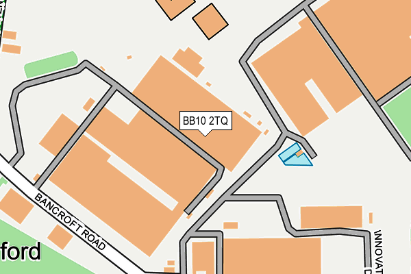
BB10 2TQ is located in the Lanehead electoral ward, within the local authority district of Burnley and the English Parliamentary constituency of Burnley. The Sub Integrated Care Board (ICB) Location is NHS Lancashire and South Cumbria ICB - 01A and the police force is Lancashire. This postcode has been in use since June 2000.


GetTheData
Source: OS OpenMap – Local (Ordnance Survey)
Source: OS VectorMap District (Ordnance Survey)
Licence: Open Government Licence (requires attribution)
| Easting | 385675 |
| Northing | 433885 |
| Latitude | 53.801066 |
| Longitude | -2.218976 |
GetTheData
Source: Open Postcode Geo
Licence: Open Government Licence
| Country | England |
| Postcode District | BB10 |
| ➜ BB10 open data dashboard ➜ See where BB10 is on a map ➜ Where is Burnley? | |
GetTheData
Source: Land Registry Price Paid Data
Licence: Open Government Licence
Elevation or altitude of BB10 2TQ as distance above sea level:
| Metres | Feet | |
|---|---|---|
| Elevation | 150m | 492ft |
Elevation is measured from the approximate centre of the postcode, to the nearest point on an OS contour line from OS Terrain 50, which has contour spacing of ten vertical metres.
➜ How high above sea level am I? Find the elevation of your current position using your device's GPS.
GetTheData
Source: Open Postcode Elevation
Licence: Open Government Licence
| Ward | Lanehead |
| Constituency | Burnley |
GetTheData
Source: ONS Postcode Database
Licence: Open Government Licence
| June 2022 | Anti-social behaviour | On or near Bancroft Road | 237m |
| June 2022 | Anti-social behaviour | On or near Bancroft Road | 237m |
| June 2022 | Violence and sexual offences | On or near Bancroft Road | 237m |
| ➜ Get more crime data in our Crime section | |||
GetTheData
Source: data.police.uk
Licence: Open Government Licence
| Sir John Thursby Coll (Eastern Avenue) | Heasandford | 272m |
| Walshaw High School (Eastern Avenue) | Heasandford | 364m |
| Thursby Road (Eastern Avenue) | Heasandford | 424m |
| Leamington Avenue (Thursby Road) | Heasandford | 432m |
| Melvile Street (Queen Victoria Road) | Browhead | 478m |
| Burnley Central Station | 1.9km |
| Burnley Manchester Road Station | 2.7km |
| Brierfield Station | 2.8km |
GetTheData
Source: NaPTAN
Licence: Open Government Licence
GetTheData
Source: ONS Postcode Database
Licence: Open Government Licence


➜ Get more ratings from the Food Standards Agency
GetTheData
Source: Food Standards Agency
Licence: FSA terms & conditions
| Last Collection | |||
|---|---|---|---|
| Location | Mon-Fri | Sat | Distance |
| 340 Colne Road | 17:30 | 11:00 | 1,204m |
| Brunshaw Top | 16:00 | 11:00 | 1,462m |
| Bank Top | 17:30 | 11:00 | 1,871m |
GetTheData
Source: Dracos
Licence: Creative Commons Attribution-ShareAlike
| Facility | Distance |
|---|---|
| Sir John Thursby Community College Eastern Avenue, Burnley Health and Fitness Gym, Sports Hall, Artificial Grass Pitch, Studio, Grass Pitches | 278m |
| Sir John Thursby Community College (Closed) Eastern Avenue, Burnley Health and Fitness Gym, Sports Hall | 278m |
| Basnett Street Playing Field Basnett Street, Basnett Street, Burnley Grass Pitches | 448m |
GetTheData
Source: Active Places
Licence: Open Government Licence
| School | Phase of Education | Distance |
|---|---|---|
| Sir John Thursby Community College Eastern Avenue, Burnley, BB10 2AT | Secondary | 278m |
| Ridgewood Community High School Eastern Avenue, Burnley, BB10 2AT | Not applicable | 287m |
| Basnett Street Nursery School Basnett Street, Basnett Street Nursery School, Burnley, BB10 3ES | Nursery | 392m |
GetTheData
Source: Edubase
Licence: Open Government Licence
The below table lists the International Territorial Level (ITL) codes (formerly Nomenclature of Territorial Units for Statistics (NUTS) codes) and Local Administrative Units (LAU) codes for BB10 2TQ:
| ITL 1 Code | Name |
|---|---|
| TLD | North West (England) |
| ITL 2 Code | Name |
| TLD4 | Lancashire |
| ITL 3 Code | Name |
| TLD46 | East Lancashire |
| LAU 1 Code | Name |
| E07000117 | Burnley |
GetTheData
Source: ONS Postcode Directory
Licence: Open Government Licence
The below table lists the Census Output Area (OA), Lower Layer Super Output Area (LSOA), and Middle Layer Super Output Area (MSOA) for BB10 2TQ:
| Code | Name | |
|---|---|---|
| OA | E00126335 | |
| LSOA | E01024892 | Burnley 001E |
| MSOA | E02005176 | Burnley 001 |
GetTheData
Source: ONS Postcode Directory
Licence: Open Government Licence
| BB10 2RZ | Bancroft Road | 236m |
| BB10 3ES | Basnett Street | 443m |
| BB10 3EU | Ennismore Street | 446m |
| BB10 3EX | Thursby Road | 451m |
| BB10 3EW | Melville Street | 457m |
| BB10 3EG | Thursby Road | 483m |
| BB10 3ET | Basnett Street | 500m |
| BB10 2AH | Netherwood Road | 510m |
| BB10 3EZ | Salus Street | 525m |
| BB10 3EN | Melville Street | 537m |
GetTheData
Source: Open Postcode Geo; Land Registry Price Paid Data
Licence: Open Government Licence