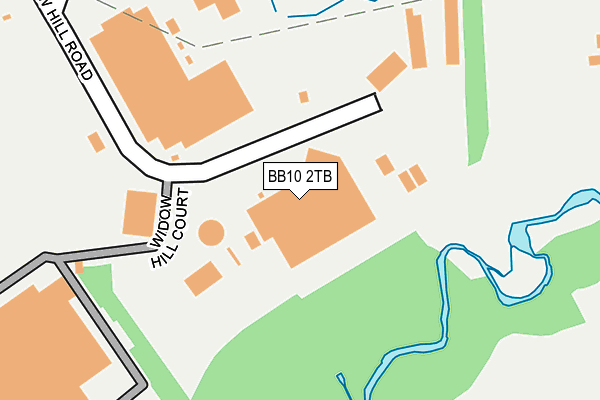
BB10 2TB is located in the Briercliffe electoral ward, within the local authority district of Burnley and the English Parliamentary constituency of Burnley. The Sub Integrated Care Board (ICB) Location is NHS Lancashire and South Cumbria ICB - 01A and the police force is Lancashire. This postcode has been in use since January 1983.


GetTheData
Source: OS OpenMap – Local (Ordnance Survey)
Source: OS VectorMap District (Ordnance Survey)
Licence: Open Government Licence (requires attribution)
| Easting | 386193 |
| Northing | 434217 |
| Latitude | 53.804078 |
| Longitude | -2.211128 |
GetTheData
Source: Open Postcode Geo
Licence: Open Government Licence
| Country | England |
| Postcode District | BB10 |
| ➜ BB10 open data dashboard ➜ See where BB10 is on a map ➜ Where is Burnley? | |
GetTheData
Source: Land Registry Price Paid Data
Licence: Open Government Licence
Elevation or altitude of BB10 2TB as distance above sea level:
| Metres | Feet | |
|---|---|---|
| Elevation | 170m | 558ft |
Elevation is measured from the approximate centre of the postcode, to the nearest point on an OS contour line from OS Terrain 50, which has contour spacing of ten vertical metres.
➜ How high above sea level am I? Find the elevation of your current position using your device's GPS.
GetTheData
Source: Open Postcode Elevation
Licence: Open Government Licence
| Ward | Briercliffe |
| Constituency | Burnley |
GetTheData
Source: ONS Postcode Database
Licence: Open Government Licence
| May 2022 | Violence and sexual offences | On or near Balderstone Close | 354m |
| May 2022 | Burglary | On or near Balderstone Close | 354m |
| May 2022 | Anti-social behaviour | On or near Balderstone Close | 354m |
| ➜ Get more crime data in our Crime section | |||
GetTheData
Source: data.police.uk
Licence: Open Government Licence
| Sir John Thursby Coll (Eastern Avenue) | Heasandford | 650m |
| St James School (Briercliffe Road) | Lane Head | 753m |
| Craven Heifer (Briercliffe Road) | Harle Syke | 759m |
| Craven Heifer (Oaken Bank) | Harle Syke | 774m |
| St James School (Marsden Road) | Lane Head | 778m |
| Burnley Central Station | 2.5km |
| Brierfield Station | 2.8km |
| Burnley Manchester Road Station | 3.3km |
GetTheData
Source: NaPTAN
Licence: Open Government Licence
GetTheData
Source: ONS Postcode Database
Licence: Open Government Licence


➜ Get more ratings from the Food Standards Agency
GetTheData
Source: Food Standards Agency
Licence: FSA terms & conditions
| Last Collection | |||
|---|---|---|---|
| Location | Mon-Fri | Sat | Distance |
| Briercliffe Road | 17:30 | 11:00 | 1,536m |
| 340 Colne Road | 17:30 | 11:00 | 1,585m |
| Brunshaw Top | 16:00 | 11:00 | 2,064m |
GetTheData
Source: Dracos
Licence: Creative Commons Attribution-ShareAlike
| Facility | Distance |
|---|---|
| Sir John Thursby Community College Eastern Avenue, Burnley Health and Fitness Gym, Sports Hall, Artificial Grass Pitch, Studio, Grass Pitches | 453m |
| Sir John Thursby Community College (Closed) Eastern Avenue, Burnley Health and Fitness Gym, Sports Hall | 453m |
| Briercliffe Recreation Ground Queen Street, Briercliffe Grass Pitches | 931m |
GetTheData
Source: Active Places
Licence: Open Government Licence
| School | Phase of Education | Distance |
|---|---|---|
| Sir John Thursby Community College Eastern Avenue, Burnley, BB10 2AT | Secondary | 453m |
| Compass Community School Lancashire Bend Hill Farm, Granville Street, Briercliffe, Burnley, BB10 2RA | Not applicable | 605m |
| Ridgewood Community High School Eastern Avenue, Burnley, BB10 2AT | Not applicable | 615m |
GetTheData
Source: Edubase
Licence: Open Government Licence
The below table lists the International Territorial Level (ITL) codes (formerly Nomenclature of Territorial Units for Statistics (NUTS) codes) and Local Administrative Units (LAU) codes for BB10 2TB:
| ITL 1 Code | Name |
|---|---|
| TLD | North West (England) |
| ITL 2 Code | Name |
| TLD4 | Lancashire |
| ITL 3 Code | Name |
| TLD46 | East Lancashire |
| LAU 1 Code | Name |
| E07000117 | Burnley |
GetTheData
Source: ONS Postcode Directory
Licence: Open Government Licence
The below table lists the Census Output Area (OA), Lower Layer Super Output Area (LSOA), and Middle Layer Super Output Area (MSOA) for BB10 2TB:
| Code | Name | |
|---|---|---|
| OA | E00126189 | |
| LSOA | E01024860 | Burnley 009A |
| MSOA | E02005184 | Burnley 009 |
GetTheData
Source: ONS Postcode Directory
Licence: Open Government Licence
| BB10 2RA | Granville Street | 355m |
| BB10 2TS | Balderstone Lane | 370m |
| BB10 2BQ | Widow Hill Road | 440m |
| BB10 2DW | Wiswell Close | 495m |
| BB10 2DT | Lydgate | 519m |
| BB10 2NT | Horning Crescent | 533m |
| BB10 2DN | Croasdale Avenue | 552m |
| BB10 2DX | Cornholme | 577m |
| BB10 3PZ | 599m | |
| BB10 2DS | Shore Avenue | 624m |
GetTheData
Source: Open Postcode Geo; Land Registry Price Paid Data
Licence: Open Government Licence