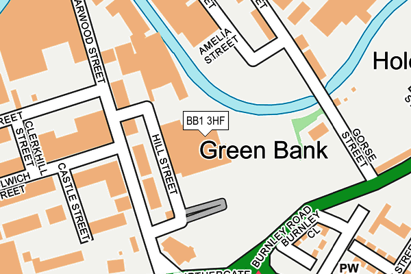
BB1 3HF is located in the Audley & Queen's Park electoral ward, within the unitary authority of Blackburn with Darwen and the English Parliamentary constituency of Blackburn. The Sub Integrated Care Board (ICB) Location is NHS Lancashire and South Cumbria ICB - 00Q and the police force is Lancashire. This postcode has been in use since April 1986.


GetTheData
Source: OS OpenMap – Local (Ordnance Survey)
Source: OS VectorMap District (Ordnance Survey)
Licence: Open Government Licence (requires attribution)
| Easting | 369815 |
| Northing | 428425 |
| Latitude | 53.751311 |
| Longitude | -2.459235 |
GetTheData
Source: Open Postcode Geo
Licence: Open Government Licence
| Country | England |
| Postcode District | BB1 |
| ➜ BB1 open data dashboard ➜ See where BB1 is on a map ➜ Where is Blackburn? | |
GetTheData
Source: Land Registry Price Paid Data
Licence: Open Government Licence
Elevation or altitude of BB1 3HF as distance above sea level:
| Metres | Feet | |
|---|---|---|
| Elevation | 130m | 427ft |
Elevation is measured from the approximate centre of the postcode, to the nearest point on an OS contour line from OS Terrain 50, which has contour spacing of ten vertical metres.
➜ How high above sea level am I? Find the elevation of your current position using your device's GPS.
GetTheData
Source: Open Postcode Elevation
Licence: Open Government Licence
| Ward | Audley & Queen's Park |
| Constituency | Blackburn |
GetTheData
Source: ONS Postcode Database
Licence: Open Government Licence
| November 2023 | Violence and sexual offences | On or near Croston Street | 371m |
| August 2023 | Violence and sexual offences | On or near Croston Street | 371m |
| May 2023 | Drugs | On or near Croston Street | 371m |
| ➜ Get more crime data in our Crime section | |||
GetTheData
Source: data.police.uk
Licence: Open Government Licence
| Gorse Street | Green Bank | 163m |
| Gorse Street | Green Bank | 184m |
| Tesco (Furthergate) | Blackburn | 187m |
| Tesco (Gorse Street) | Blackburn | 227m |
| Burnley Road (Gorse Street) | Blackburn | 239m |
| Blackburn Station | 1.4km |
| Rishton Station | 2.9km |
| Mill Hill (Lancs) Station | 3.3km |
GetTheData
Source: NaPTAN
Licence: Open Government Licence
GetTheData
Source: ONS Postcode Database
Licence: Open Government Licence


➜ Get more ratings from the Food Standards Agency
GetTheData
Source: Food Standards Agency
Licence: FSA terms & conditions
| Last Collection | |||
|---|---|---|---|
| Location | Mon-Fri | Sat | Distance |
| Furthergate Ind Estate | 18:00 | 13:00 | 231m |
| Furthergate Ind Estate | 18:00 | 00:01 | 234m |
| Longton Street | 17:15 | 13:15 | 608m |
GetTheData
Source: Dracos
Licence: Creative Commons Attribution-ShareAlike
| Facility | Distance |
|---|---|
| St. Thomas C Of E Primary School Newton Street, Blackburn Grass Pitches | 397m |
| Little Harwood Stp St. Stephens Road, Blackburn Artificial Grass Pitch | 757m |
| St Stephens Ce Primary School Robinson Street, Blackburn Grass Pitches | 813m |
GetTheData
Source: Active Places
Licence: Open Government Licence
| School | Phase of Education | Distance |
|---|---|---|
| Jamiatul-Ilm Wal-Huda UK School 30 Moss Street, Blackburn, BB1 5JT | Not applicable | 495m |
| Rawdhatul Ilm Wal Huda 32 Moss Street, Blackburn, BB1 5JT | Not applicable | 505m |
| Blackburn St Thomas' Church of England Primary School Newton Street, Blackburn, BB1 1NE | Primary | 507m |
GetTheData
Source: Edubase
Licence: Open Government Licence
The below table lists the International Territorial Level (ITL) codes (formerly Nomenclature of Territorial Units for Statistics (NUTS) codes) and Local Administrative Units (LAU) codes for BB1 3HF:
| ITL 1 Code | Name |
|---|---|
| TLD | North West (England) |
| ITL 2 Code | Name |
| TLD4 | Lancashire |
| ITL 3 Code | Name |
| TLD41 | Blackburn with Darwen |
| LAU 1 Code | Name |
| E06000008 | Blackburn with Darwen |
GetTheData
Source: ONS Postcode Directory
Licence: Open Government Licence
The below table lists the Census Output Area (OA), Lower Layer Super Output Area (LSOA), and Middle Layer Super Output Area (MSOA) for BB1 3HF:
| Code | Name | |
|---|---|---|
| OA | E00063413 | |
| LSOA | E01012576 | Blackburn with Darwen 008A |
| MSOA | E02002622 | Blackburn with Darwen 008 |
GetTheData
Source: ONS Postcode Directory
Licence: Open Government Licence
| BB1 3HD | Crabtree Street | 137m |
| BB1 3HL | Burnley Close | 206m |
| BB1 3ES | Gladstone Street | 214m |
| BB1 3EU | Gorse Street | 223m |
| BB1 1UQ | Mulberry Street | 285m |
| BB1 1NS | Frederick Row | 291m |
| BB1 2AA | Accrington Road | 300m |
| BB1 3JL | Didsbury Street | 305m |
| BB1 1XE | Acacia Walk | 349m |
| BB1 3AE | Ordnance Street | 363m |
GetTheData
Source: Open Postcode Geo; Land Registry Price Paid Data
Licence: Open Government Licence