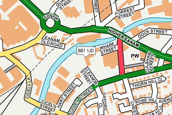
BB1 1JD is located in the Blackburn Central electoral ward, within the unitary authority of Blackburn with Darwen and the English Parliamentary constituency of Blackburn. The Sub Integrated Care Board (ICB) Location is NHS Lancashire and South Cumbria ICB - 00Q and the police force is Lancashire. This postcode has been in use since January 2004.


GetTheData
Source: OS OpenMap – Local (Ordnance Survey)
Source: OS VectorMap District (Ordnance Survey)
Licence: Open Government Licence (requires attribution)
| Easting | 368888 |
| Northing | 428117 |
| Latitude | 53.748488 |
| Longitude | -2.473261 |
GetTheData
Source: Open Postcode Geo
Licence: Open Government Licence
| Country | England |
| Postcode District | BB1 |
| ➜ BB1 open data dashboard ➜ See where BB1 is on a map ➜ Where is Blackburn? | |
GetTheData
Source: Land Registry Price Paid Data
Licence: Open Government Licence
Elevation or altitude of BB1 1JD as distance above sea level:
| Metres | Feet | |
|---|---|---|
| Elevation | 130m | 427ft |
Elevation is measured from the approximate centre of the postcode, to the nearest point on an OS contour line from OS Terrain 50, which has contour spacing of ten vertical metres.
➜ How high above sea level am I? Find the elevation of your current position using your device's GPS.
GetTheData
Source: Open Postcode Elevation
Licence: Open Government Licence
| Ward | Blackburn Central |
| Constituency | Blackburn |
GetTheData
Source: ONS Postcode Database
Licence: Open Government Licence
| November 2023 | Anti-social behaviour | On or near Cranwell Close | 228m |
| October 2023 | Anti-social behaviour | On or near Cicely Street | 215m |
| May 2023 | Drugs | On or near Cicely Street | 215m |
| ➜ Get more crime data in our Crime section | |||
GetTheData
Source: data.police.uk
Licence: Open Government Licence
| Chester Street (Higher Audley Street) | Audley | 103m |
| Eanam Wharf (Eanam) | Blackburn | 105m |
| Thornhill Close (Chester Street) | Audley | 174m |
| Chester Street | Audley | 193m |
| Chester Street (Higher Audley St) | Audley | 194m |
| Blackburn Station | 0.4km |
| Mill Hill (Lancs) Station | 2.4km |
| Cherry Tree Station | 3.4km |
GetTheData
Source: NaPTAN
Licence: Open Government Licence
GetTheData
Source: ONS Postcode Database
Licence: Open Government Licence


➜ Get more ratings from the Food Standards Agency
GetTheData
Source: Food Standards Agency
Licence: FSA terms & conditions
| Last Collection | |||
|---|---|---|---|
| Location | Mon-Fri | Sat | Distance |
| Railway Station | 16:30 | 12:15 | 509m |
| Church Street | 16:30 | 13:00 | 549m |
| Blackburn Cathedral | 16:30 | 13:00 | 643m |
GetTheData
Source: Dracos
Licence: Creative Commons Attribution-ShareAlike
| Facility | Distance |
|---|---|
| Audley Centre Chester Street, Blackburn Sports Hall, Health and Fitness Gym, Studio | 358m |
| Dw Sports Fitness (Blackburn Centre) (Closed) Mayson Street, Blackburn Swimming Pool, Health and Fitness Gym, Studio | 559m |
| Half Fish Hq Daisy Lane, Blackburn Swimming Pool | 622m |
GetTheData
Source: Active Places
Licence: Open Government Licence
| School | Phase of Education | Distance |
|---|---|---|
| St Matthew's Church of England Primary School Withers Street, Blackburn, BB1 1DF | Primary | 281m |
| Brunel Nursery School Cambridge Street, Blackburn, BB1 1ES | Nursery | 314m |
| St Alban's Roman Catholic Primary School Blackburn Trinity Street, Blackburn, BB1 5BN | Primary | 420m |
GetTheData
Source: Edubase
Licence: Open Government Licence
The below table lists the International Territorial Level (ITL) codes (formerly Nomenclature of Territorial Units for Statistics (NUTS) codes) and Local Administrative Units (LAU) codes for BB1 1JD:
| ITL 1 Code | Name |
|---|---|
| TLD | North West (England) |
| ITL 2 Code | Name |
| TLD4 | Lancashire |
| ITL 3 Code | Name |
| TLD41 | Blackburn with Darwen |
| LAU 1 Code | Name |
| E06000008 | Blackburn with Darwen |
GetTheData
Source: ONS Postcode Directory
Licence: Open Government Licence
The below table lists the Census Output Area (OA), Lower Layer Super Output Area (LSOA), and Middle Layer Super Output Area (MSOA) for BB1 1JD:
| Code | Name | |
|---|---|---|
| OA | E00063404 | |
| LSOA | E01012572 | Blackburn with Darwen 007B |
| MSOA | E02002621 | Blackburn with Darwen 007 |
GetTheData
Source: ONS Postcode Directory
Licence: Open Government Licence
| BB1 5BL | Eanam Wharf | 66m |
| BB1 5BX | Eanam Wharf | 69m |
| BB1 5BY | Eanam | 101m |
| BB1 1JA | Higher Barn Street | 132m |
| BB1 1DU | Dartford Close | 151m |
| BB1 1DL | Oxford Close | 172m |
| BB1 1DR | Chester Street | 197m |
| BB1 1JB | Higher Audley Street | 201m |
| BB1 1DY | Cambridge Close | 202m |
| BB1 3AZ | Higher Eanam | 207m |
GetTheData
Source: Open Postcode Geo; Land Registry Price Paid Data
Licence: Open Government Licence