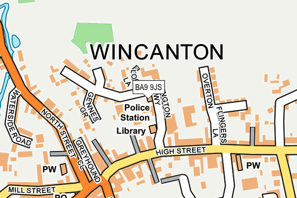
BA9 9JS is located in the Wincanton & Bruton electoral ward, within the unitary authority of Somerset and the English Parliamentary constituency of Somerton and Frome. The Sub Integrated Care Board (ICB) Location is NHS Somerset ICB - 11X and the police force is Avon and Somerset. This postcode has been in use since January 1980.


GetTheData
Source: OS OpenMap – Local (Ordnance Survey)
Source: OS VectorMap District (Ordnance Survey)
Licence: Open Government Licence (requires attribution)
| Easting | 371392 |
| Northing | 128790 |
| Latitude | 51.057726 |
| Longitude | -2.409570 |
GetTheData
Source: Open Postcode Geo
Licence: Open Government Licence
| Country | England |
| Postcode District | BA9 |
| ➜ BA9 open data dashboard ➜ See where BA9 is on a map ➜ Where is Wincanton? | |
GetTheData
Source: Land Registry Price Paid Data
Licence: Open Government Licence
Elevation or altitude of BA9 9JS as distance above sea level:
| Metres | Feet | |
|---|---|---|
| Elevation | 100m | 328ft |
Elevation is measured from the approximate centre of the postcode, to the nearest point on an OS contour line from OS Terrain 50, which has contour spacing of ten vertical metres.
➜ How high above sea level am I? Find the elevation of your current position using your device's GPS.
GetTheData
Source: Open Postcode Elevation
Licence: Open Government Licence
| Ward | Wincanton & Bruton |
| Constituency | Somerton And Frome |
GetTheData
Source: ONS Postcode Database
Licence: Open Government Licence
| December 2023 | Vehicle crime | On or near Parking Area | 35m |
| December 2023 | Public order | On or near South Street | 436m |
| November 2023 | Other theft | On or near Parking Area | 35m |
| ➜ Get more crime data in our Crime section | |||
GetTheData
Source: data.police.uk
Licence: Open Government Licence
| High Street | Wincanton | 130m |
| High Street | Wincanton | 138m |
| Wincanton Methodist Church (High Street) | Wincanton | 195m |
| Market Place | Wincanton | 208m |
| Wincanton Methodist Church (High Street) | Wincanton | 208m |
GetTheData
Source: NaPTAN
Licence: Open Government Licence
Estimated total energy consumption in BA9 9JS by fuel type, 2015.
| Consumption (kWh) | 106,605 |
|---|---|
| Meter count | 8 |
| Mean (kWh/meter) | 13,326 |
| Median (kWh/meter) | 10,904 |
| Consumption (kWh) | 20,766 |
|---|---|
| Meter count | 7 |
| Mean (kWh/meter) | 2,967 |
| Median (kWh/meter) | 2,580 |
GetTheData
Source: Postcode level gas estimates: 2015 (experimental)
Source: Postcode level electricity estimates: 2015 (experimental)
Licence: Open Government Licence
GetTheData
Source: ONS Postcode Database
Licence: Open Government Licence


➜ Get more ratings from the Food Standards Agency
GetTheData
Source: Food Standards Agency
Licence: FSA terms & conditions
| Last Collection | |||
|---|---|---|---|
| Location | Mon-Fri | Sat | Distance |
| North Street | 17:30 | 11:30 | 282m |
| South Road | 17:30 | 11:30 | 590m |
| Shalford | 11:00 | 09:30 | 1,284m |
GetTheData
Source: Dracos
Licence: Creative Commons Attribution-ShareAlike
| Facility | Distance |
|---|---|
| Wincanton Memorial Hall High Street, Wincanton Sports Hall | 263m |
| Wincanton Cricket Club Station Road, Wincanton Grass Pitches | 694m |
| Wincanton Sports Centre West Hill, Wincanton Sports Hall, Swimming Pool, Health and Fitness Gym, Studio | 993m |
GetTheData
Source: Active Places
Licence: Open Government Licence
| School | Phase of Education | Distance |
|---|---|---|
| Our Lady of Mount Carmel Catholic Primary Tout Hill, Wincanton, BA9 9DH | Primary | 233m |
| Wincanton Primary School Station Road, Wincanton, BA9 9EL | Primary | 494m |
| King Arthur's School West Hill, Wincanton, BA9 9BX | Secondary | 1.1km |
GetTheData
Source: Edubase
Licence: Open Government Licence
The below table lists the International Territorial Level (ITL) codes (formerly Nomenclature of Territorial Units for Statistics (NUTS) codes) and Local Administrative Units (LAU) codes for BA9 9JS:
| ITL 1 Code | Name |
|---|---|
| TLK | South West (England) |
| ITL 2 Code | Name |
| TLK2 | Dorset and Somerset |
| ITL 3 Code | Name |
| TLK23 | Somerset CC |
| LAU 1 Code | Name |
| E07000189 | South Somerset |
GetTheData
Source: ONS Postcode Directory
Licence: Open Government Licence
The below table lists the Census Output Area (OA), Lower Layer Super Output Area (LSOA), and Middle Layer Super Output Area (MSOA) for BA9 9JS:
| Code | Name | |
|---|---|---|
| OA | E00148890 | |
| LSOA | E01029227 | South Somerset 005B |
| MSOA | E02006079 | South Somerset 005 |
GetTheData
Source: ONS Postcode Directory
Licence: Open Government Licence
| BA9 9JR | Locks Lane | 74m |
| BA9 9NT | Les Rosiers Grove | 102m |
| BA9 9JT | High Street | 104m |
| BA9 9JH | Carrington Way | 108m |
| BA9 9JQ | High Street | 121m |
| BA9 9JU | High Street | 122m |
| BA9 9JP | High Street | 136m |
| BA9 9LE | Flingers Lane | 136m |
| BA9 9LF | Overton | 136m |
| BA9 9NU | Gennes Grove | 139m |
GetTheData
Source: Open Postcode Geo; Land Registry Price Paid Data
Licence: Open Government Licence