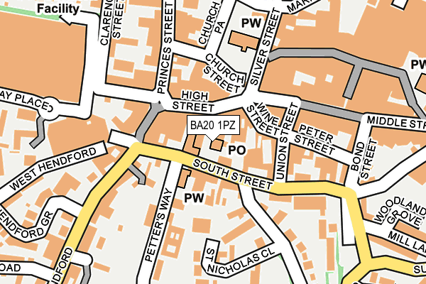
BA20 1PZ is located in the Yeovil South electoral ward, within the unitary authority of Somerset and the English Parliamentary constituency of Yeovil. The Sub Integrated Care Board (ICB) Location is NHS Somerset ICB - 11X and the police force is Avon and Somerset. This postcode has been in use since January 1980.


GetTheData
Source: OS OpenMap – Local (Ordnance Survey)
Source: OS VectorMap District (Ordnance Survey)
Licence: Open Government Licence (requires attribution)
| Easting | 355635 |
| Northing | 115913 |
| Latitude | 50.940941 |
| Longitude | -2.632809 |
GetTheData
Source: Open Postcode Geo
Licence: Open Government Licence
| Country | England |
| Postcode District | BA20 |
| ➜ BA20 open data dashboard ➜ See where BA20 is on a map ➜ Where is Yeovil? | |
GetTheData
Source: Land Registry Price Paid Data
Licence: Open Government Licence
Elevation or altitude of BA20 1PZ as distance above sea level:
| Metres | Feet | |
|---|---|---|
| Elevation | 50m | 164ft |
Elevation is measured from the approximate centre of the postcode, to the nearest point on an OS contour line from OS Terrain 50, which has contour spacing of ten vertical metres.
➜ How high above sea level am I? Find the elevation of your current position using your device's GPS.
GetTheData
Source: Open Postcode Elevation
Licence: Open Government Licence
| Ward | Yeovil South |
| Constituency | Yeovil |
GetTheData
Source: ONS Postcode Database
Licence: Open Government Licence
| January 2024 | Anti-social behaviour | On or near Shopping Area | 121m |
| January 2024 | Anti-social behaviour | On or near Shopping Area | 121m |
| January 2024 | Burglary | On or near Shopping Area | 121m |
| ➜ Get more crime data in our Crime section | |||
GetTheData
Source: data.police.uk
Licence: Open Government Licence
| South Street | Yeovil | 41m |
| The Borough (High Street) | Yeovil | 75m |
| Denners (Hendford) | Yeovil | 104m |
| St Nicholas Close | Yeovil | 183m |
| Tesco (Clarence Street) | Yeovil | 224m |
| Yeovil Pen Mill Station | 1.4km |
| Yeovil Junction Station | 2.3km |
| Thornford Station | 5.1km |
GetTheData
Source: NaPTAN
Licence: Open Government Licence
GetTheData
Source: ONS Postcode Database
Licence: Open Government Licence


➜ Get more ratings from the Food Standards Agency
GetTheData
Source: Food Standards Agency
Licence: FSA terms & conditions
| Last Collection | |||
|---|---|---|---|
| Location | Mon-Fri | Sat | Distance |
| Sherborne Road | 16:30 | 12:00 | 86m |
| Middle Street | 17:30 | 12:00 | 166m |
| The Park | 16:00 | 12:00 | 166m |
GetTheData
Source: Dracos
Licence: Creative Commons Attribution-ShareAlike
| Facility | Distance |
|---|---|
| Anytime Fitness (Yeovil) Frederick Place, Middle Street, Middle Street, Yeovil Health and Fitness Gym | 184m |
| Trimwise (Closed) Park Road, Yeovil Studio, Health and Fitness Gym | 229m |
| Vicarage Street Methodist Church Hall Middle Street, Yeovil Sports Hall | 308m |
GetTheData
Source: Active Places
Licence: Open Government Licence
| School | Phase of Education | Distance |
|---|---|---|
| St Gildas Catholic Primary School Mary Street, Yeovil, BA21 4EG | Primary | 437m |
| South Somerset Partnership School Dampier Street, Yeovil, BA21 4EN | Not applicable | 497m |
| Huish Primary School Carisbrooke Gardens, Yeovil, BA20 1AY | Primary | 549m |
GetTheData
Source: Edubase
Licence: Open Government Licence
The below table lists the International Territorial Level (ITL) codes (formerly Nomenclature of Territorial Units for Statistics (NUTS) codes) and Local Administrative Units (LAU) codes for BA20 1PZ:
| ITL 1 Code | Name |
|---|---|
| TLK | South West (England) |
| ITL 2 Code | Name |
| TLK2 | Dorset and Somerset |
| ITL 3 Code | Name |
| TLK23 | Somerset CC |
| LAU 1 Code | Name |
| E07000189 | South Somerset |
GetTheData
Source: ONS Postcode Directory
Licence: Open Government Licence
The below table lists the Census Output Area (OA), Lower Layer Super Output Area (LSOA), and Middle Layer Super Output Area (MSOA) for BA20 1PZ:
| Code | Name | |
|---|---|---|
| OA | E00148930 | |
| LSOA | E01029234 | South Somerset 015B |
| MSOA | E02006089 | South Somerset 015 |
GetTheData
Source: ONS Postcode Directory
Licence: Open Government Licence
| BA20 1RQ | High Street | 41m |
| BA20 1RF | High Street | 46m |
| BA20 1ND | South Street | 62m |
| BA20 1RE | High Street | 68m |
| BA20 1PW | Wine Street | 70m |
| BA20 1TW | South Street | 82m |
| BA20 1RX | The Borough Arcade | 90m |
| BA20 1LZ | Middle Street | 94m |
| BA20 1PQ | Union Street | 108m |
| BA20 1TE | Hendford | 119m |
GetTheData
Source: Open Postcode Geo; Land Registry Price Paid Data
Licence: Open Government Licence