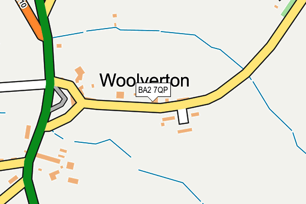
BA2 7QP is in Woolverton, Bath. BA2 7QP is located in the Frome North electoral ward, within the unitary authority of Somerset and the English Parliamentary constituency of Somerton and Frome. The Sub Integrated Care Board (ICB) Location is NHS Somerset ICB - 11X and the police force is Avon and Somerset. This postcode has been in use since June 2001.


GetTheData
Source: OS OpenMap – Local (Ordnance Survey)
Source: OS VectorMap District (Ordnance Survey)
Licence: Open Government Licence (requires attribution)
| Easting | 379369 |
| Northing | 154024 |
| Latitude | 51.284976 |
| Longitude | -2.297208 |
GetTheData
Source: Open Postcode Geo
Licence: Open Government Licence
| Locality | Woolverton |
| Town/City | Bath |
| Country | England |
| Postcode District | BA2 |
| ➜ BA2 open data dashboard ➜ See where BA2 is on a map ➜ Where is Woolverton? | |
GetTheData
Source: Land Registry Price Paid Data
Licence: Open Government Licence
Elevation or altitude of BA2 7QP as distance above sea level:
| Metres | Feet | |
|---|---|---|
| Elevation | 60m | 197ft |
Elevation is measured from the approximate centre of the postcode, to the nearest point on an OS contour line from OS Terrain 50, which has contour spacing of ten vertical metres.
➜ How high above sea level am I? Find the elevation of your current position using your device's GPS.
GetTheData
Source: Open Postcode Elevation
Licence: Open Government Licence
| Ward | Frome North |
| Constituency | Somerton And Frome |
GetTheData
Source: ONS Postcode Database
Licence: Open Government Licence
| February 2022 | Violence and sexual offences | On or near The Leaze | 63m |
| January 2022 | Other theft | On or near The Leaze | 63m |
| July 2021 | Other theft | On or near The Leaze | 63m |
| ➜ Get more crime data in our Crime section | |||
GetTheData
Source: data.police.uk
Licence: Open Government Licence
| East Terrace | Woolverton | 49m |
| East Terrace | Woolverton | 58m |
| Red Lion | Woolverton | 135m |
| Red Lion | Woolverton | 140m |
| Red Lion | Woolverton | 210m |
GetTheData
Source: NaPTAN
Licence: Open Government Licence
| Percentage of properties with Next Generation Access | 0.0% |
| Percentage of properties with Superfast Broadband | 0.0% |
| Percentage of properties with Ultrafast Broadband | 0.0% |
| Percentage of properties with Full Fibre Broadband | 0.0% |
Superfast Broadband is between 30Mbps and 300Mbps
Ultrafast Broadband is > 300Mbps
| Percentage of properties unable to receive 2Mbps | 0.0% |
| Percentage of properties unable to receive 5Mbps | 0.0% |
| Percentage of properties unable to receive 10Mbps | 75.0% |
| Percentage of properties unable to receive 30Mbps | 100.0% |
GetTheData
Source: Ofcom
Licence: Ofcom Terms of Use (requires attribution)
GetTheData
Source: ONS Postcode Database
Licence: Open Government Licence


➜ Get more ratings from the Food Standards Agency
GetTheData
Source: Food Standards Agency
Licence: FSA terms & conditions
| Last Collection | |||
|---|---|---|---|
| Location | Mon-Fri | Sat | Distance |
| The Ship | 15:20 | 08:00 | 3,562m |
| Brokerswood | 12:00 | 10:00 | 4,661m |
| Hinton Charterhouse | 17:30 | 11:30 | 4,723m |
GetTheData
Source: Dracos
Licence: Creative Commons Attribution-ShareAlike
| Facility | Distance |
|---|---|
| Rode Playing Field Orneage Close, Rode, Frome Grass Pitches | 1.2km |
| Beckington Recreation Ground Bath Road, Beckington, Frome Grass Pitches | 1.9km |
| Norton St Philip Cricket Club Fair Close, Norton St Philip, Frome Grass Pitches | 2.7km |
GetTheData
Source: Active Places
Licence: Open Government Licence
| School | Phase of Education | Distance |
|---|---|---|
| Rode Methodist VC First School High Street, Rode, Frome, BA11 6NZ | Primary | 951m |
| Beckington Church of England First School Church Street, Beckington, Frome, BA11 6TG | Primary | 2.5km |
| Springmead Preparatory School Castle Corner, Beckington, Somerset, BA11 6TA | Not applicable | 2.5km |
GetTheData
Source: Edubase
Licence: Open Government Licence
The below table lists the International Territorial Level (ITL) codes (formerly Nomenclature of Territorial Units for Statistics (NUTS) codes) and Local Administrative Units (LAU) codes for BA2 7QP:
| ITL 1 Code | Name |
|---|---|
| TLK | South West (England) |
| ITL 2 Code | Name |
| TLK2 | Dorset and Somerset |
| ITL 3 Code | Name |
| TLK23 | Somerset CC |
| LAU 1 Code | Name |
| E07000187 | Mendip |
GetTheData
Source: ONS Postcode Directory
Licence: Open Government Licence
The below table lists the Census Output Area (OA), Lower Layer Super Output Area (LSOA), and Middle Layer Super Output Area (MSOA) for BA2 7QP:
| Code | Name | |
|---|---|---|
| OA | E00147813 | |
| LSOA | E01029022 | Mendip 001A |
| MSOA | E02006047 | Mendip 001 |
GetTheData
Source: ONS Postcode Directory
Licence: Open Government Licence
| BA2 7QR | The Leazes | 81m |
| BA2 7QS | West Terrace | 140m |
| BA2 7QT | 250m | |
| BA11 6SQ | Shawford | 648m |
| BA11 6QW | 689m | |
| BA11 6PF | The Mead | 858m |
| BA11 6AD | High Street | 894m |
| BA11 6NA | Red Lion Gardens | 956m |
| BA11 6PY | 976m | |
| BA11 6NZ | High Street | 980m |
GetTheData
Source: Open Postcode Geo; Land Registry Price Paid Data
Licence: Open Government Licence