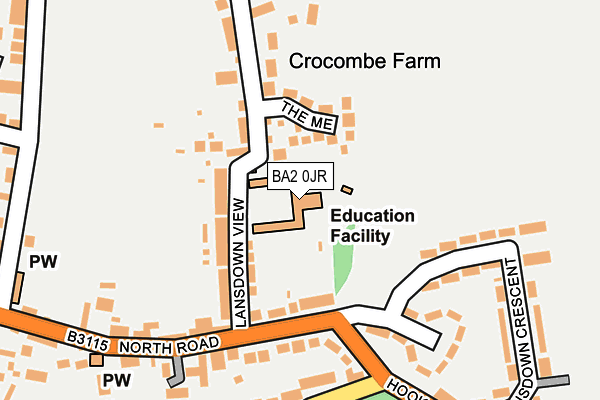
BA2 0JR is located in the Timsbury electoral ward, within the unitary authority of Bath and North East Somerset and the English Parliamentary constituency of North East Somerset. The Sub Integrated Care Board (ICB) Location is NHS Bath and North East Somerset, Swindon and Wiltshire ICB - 92 and the police force is Avon and Somerset. This postcode has been in use since June 2001.


GetTheData
Source: OS OpenMap – Local (Ordnance Survey)
Source: OS VectorMap District (Ordnance Survey)
Licence: Open Government Licence (requires attribution)
| Easting | 367233 |
| Northing | 158989 |
| Latitude | 51.329043 |
| Longitude | -2.471676 |
GetTheData
Source: Open Postcode Geo
Licence: Open Government Licence
| Country | England |
| Postcode District | BA2 |
| ➜ BA2 open data dashboard ➜ See where BA2 is on a map ➜ Where is Timsbury? | |
GetTheData
Source: Land Registry Price Paid Data
Licence: Open Government Licence
Elevation or altitude of BA2 0JR as distance above sea level:
| Metres | Feet | |
|---|---|---|
| Elevation | 140m | 459ft |
Elevation is measured from the approximate centre of the postcode, to the nearest point on an OS contour line from OS Terrain 50, which has contour spacing of ten vertical metres.
➜ How high above sea level am I? Find the elevation of your current position using your device's GPS.
GetTheData
Source: Open Postcode Elevation
Licence: Open Government Licence
| Ward | Timsbury |
| Constituency | North East Somerset |
GetTheData
Source: ONS Postcode Database
Licence: Open Government Licence
| June 2022 | Violence and sexual offences | On or near Lansdown View | 83m |
| June 2022 | Violence and sexual offences | On or near Lansdown Crescent | 192m |
| June 2022 | Violence and sexual offences | On or near Sports/Recreation Area | 429m |
| ➜ Get more crime data in our Crime section | |||
GetTheData
Source: data.police.uk
Licence: Open Government Licence
| Lansdown View (North Road) | Timsbury | 142m |
| Lansdown Crescent (Hook Hill) | Timsbury | 307m |
| Homefield (South Road) | Timsbury | 310m |
| British Legion (North Road) | Timsbury | 351m |
| British Legion (North Road) | Timsbury | 351m |
GetTheData
Source: NaPTAN
Licence: Open Government Licence
GetTheData
Source: ONS Postcode Database
Licence: Open Government Licence

➜ Get more ratings from the Food Standards Agency
GetTheData
Source: Food Standards Agency
Licence: FSA terms & conditions
| Last Collection | |||
|---|---|---|---|
| Location | Mon-Fri | Sat | Distance |
| North Road | 17:15 | 10:00 | 152m |
| Timsbury Post Office | 17:15 | 11:00 | 470m |
| Bloomfield Road | 12:00 | 12:00 | 645m |
GetTheData
Source: Dracos
Licence: Creative Commons Attribution-ShareAlike
| Facility | Distance |
|---|---|
| St Mary's C Of E Primary School Sports Field Lansdown View, Timsbury, Bath Sports Hall, Grass Pitches | 3m |
| Timsbury Recreation Ground North Road, Timsbury, Bath Sports Hall, Grass Pitches, Outdoor Tennis Courts | 384m |
| Camerton Community Hall Meadgate, Camerton, Bath Grass Pitches, Sports Hall | 841m |
GetTheData
Source: Active Places
Licence: Open Government Licence
| School | Phase of Education | Distance |
|---|---|---|
| St Mary's CofE Primary School Lansdown View, Timsbury, Bath, BA2 0JR | Primary | 0m |
| Farmborough Church Primary School The Street, Farmborough, Bath, BA2 0FY | Primary | 2.1km |
| High Littleton CofE VC Primary School Church Hill, High Littleton, Bristol, BS39 6HF | Primary | 2.9km |
GetTheData
Source: Edubase
Licence: Open Government Licence
The below table lists the International Territorial Level (ITL) codes (formerly Nomenclature of Territorial Units for Statistics (NUTS) codes) and Local Administrative Units (LAU) codes for BA2 0JR:
| ITL 1 Code | Name |
|---|---|
| TLK | South West (England) |
| ITL 2 Code | Name |
| TLK1 | Gloucestershire, Wiltshire and Bath/Bristol area |
| ITL 3 Code | Name |
| TLK12 | Bath and North East Somerset, North Somerset and South Gloucestershire |
| LAU 1 Code | Name |
| E06000022 | Bath and North East Somerset |
GetTheData
Source: ONS Postcode Directory
Licence: Open Government Licence
The below table lists the Census Output Area (OA), Lower Layer Super Output Area (LSOA), and Middle Layer Super Output Area (MSOA) for BA2 0JR:
| Code | Name | |
|---|---|---|
| OA | E00073023 | |
| LSOA | E01014460 | Bath and North East Somerset 016G |
| MSOA | E02003000 | Bath and North East Somerset 016 |
GetTheData
Source: ONS Postcode Directory
Licence: Open Government Licence
| BA2 0NS | The Mead | 70m |
| BA2 0JW | Crocombe Lane | 83m |
| BA2 0JP | Lansdown View | 92m |
| BA2 0JN | North Road | 106m |
| BA2 0JS | Crocombe | 138m |
| BA2 0JJ | North Road | 198m |
| BA2 0JX | Lansdown Crescent | 228m |
| BA2 0NA | South Road | 239m |
| BA2 0JH | North Road | 242m |
| BA2 0LU | Homefield | 289m |
GetTheData
Source: Open Postcode Geo; Land Registry Price Paid Data
Licence: Open Government Licence