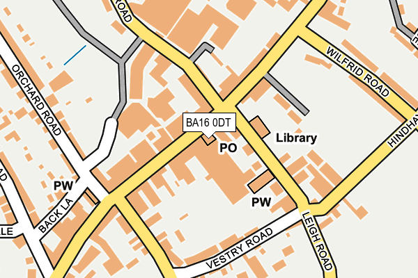
BA16 0DT is located in the Street electoral ward, within the unitary authority of Somerset and the English Parliamentary constituency of Wells. The Sub Integrated Care Board (ICB) Location is NHS Somerset ICB - 11X and the police force is Avon and Somerset. This postcode has been in use since January 1980.


GetTheData
Source: OS OpenMap – Local (Ordnance Survey)
Source: OS VectorMap District (Ordnance Survey)
Licence: Open Government Licence (requires attribution)
| Easting | 348308 |
| Northing | 136608 |
| Latitude | 51.126407 |
| Longitude | -2.740043 |
GetTheData
Source: Open Postcode Geo
Licence: Open Government Licence
| Country | England |
| Postcode District | BA16 |
| ➜ BA16 open data dashboard ➜ See where BA16 is on a map ➜ Where is Street? | |
GetTheData
Source: Land Registry Price Paid Data
Licence: Open Government Licence
Elevation or altitude of BA16 0DT as distance above sea level:
| Metres | Feet | |
|---|---|---|
| Elevation | 20m | 66ft |
Elevation is measured from the approximate centre of the postcode, to the nearest point on an OS contour line from OS Terrain 50, which has contour spacing of ten vertical metres.
➜ How high above sea level am I? Find the elevation of your current position using your device's GPS.
GetTheData
Source: Open Postcode Elevation
Licence: Open Government Licence
| Ward | Street |
| Constituency | Wells |
GetTheData
Source: ONS Postcode Database
Licence: Open Government Licence
| January 2024 | Other theft | On or near Parking Area | 215m |
| January 2024 | Violence and sexual offences | On or near Parking Area | 359m |
| November 2023 | Violence and sexual offences | On or near Durston Close | 303m |
| ➜ Get more crime data in our Crime section | |||
GetTheData
Source: data.police.uk
Licence: Open Government Licence
| Crispin Hall (Leigh Road) | Street | 46m |
| The Library (Leigh Road) | Street | 69m |
| The Surgery (Hindhayes Lane) | Street | 201m |
| Church (High Street) | Street | 201m |
| Hindhayes School | Street | 205m |
GetTheData
Source: NaPTAN
Licence: Open Government Licence
GetTheData
Source: ONS Postcode Database
Licence: Open Government Licence


➜ Get more ratings from the Food Standards Agency
GetTheData
Source: Food Standards Agency
Licence: FSA terms & conditions
| Last Collection | |||
|---|---|---|---|
| Location | Mon-Fri | Sat | Distance |
| Street Post Office | 18:00 | 12:00 | 22m |
| Clarks Village | 16:00 | 11:30 | 231m |
| Cranhill Road | 16:00 | 11:30 | 334m |
GetTheData
Source: Dracos
Licence: Creative Commons Attribution-ShareAlike
| Facility | Distance |
|---|---|
| Greenbank Swimming Pool Wilfrid Road, Street Swimming Pool | 199m |
| Victoria Field Sports And Social Club Leigh Road, Street Indoor Bowls, Grass Pitches, Squash Courts, Outdoor Tennis Courts, Sports Hall | 399m |
| Elmhurst Junior School Elmhurst Lane, Street Grass Pitches, Outdoor Tennis Courts | 530m |
GetTheData
Source: Active Places
Licence: Open Government Licence
| School | Phase of Education | Distance |
|---|---|---|
| Hindhayes Infant School Leigh Road, Street, BA16 0HB | Primary | 374m |
| Elmhurst Junior School Elmhurst Lane, Street, BA16 0HH | Primary | 530m |
| Strode College Church Road, Street, BA16 0AB | 16 plus | 660m |
GetTheData
Source: Edubase
Licence: Open Government Licence
The below table lists the International Territorial Level (ITL) codes (formerly Nomenclature of Territorial Units for Statistics (NUTS) codes) and Local Administrative Units (LAU) codes for BA16 0DT:
| ITL 1 Code | Name |
|---|---|
| TLK | South West (England) |
| ITL 2 Code | Name |
| TLK2 | Dorset and Somerset |
| ITL 3 Code | Name |
| TLK23 | Somerset CC |
| LAU 1 Code | Name |
| E07000187 | Mendip |
GetTheData
Source: ONS Postcode Directory
Licence: Open Government Licence
The below table lists the Census Output Area (OA), Lower Layer Super Output Area (LSOA), and Middle Layer Super Output Area (MSOA) for BA16 0DT:
| Code | Name | |
|---|---|---|
| OA | E00148057 | |
| LSOA | E01029070 | Mendip 014A |
| MSOA | E02006060 | Mendip 014 |
GetTheData
Source: ONS Postcode Directory
Licence: Open Government Licence
| BA16 0EH | High Street | 65m |
| BA16 0EW | High Street | 99m |
| BA16 0BJ | Farm Road | 102m |
| BA16 0EY | High Street | 105m |
| BA16 0HA | Leigh Road | 106m |
| BA16 0EG | High Street | 113m |
| BA16 0EQ | High Street | 134m |
| BA16 0HY | Vestry Road | 175m |
| BA16 0HX | Vestry Road | 179m |
| BA16 0BA | Orchard Road | 210m |
GetTheData
Source: Open Postcode Geo; Land Registry Price Paid Data
Licence: Open Government Licence