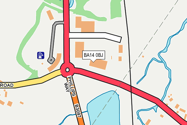
BA14 0BJ is located in the Trowbridge Drynham electoral ward, within the unitary authority of Wiltshire and the English Parliamentary constituency of South West Wiltshire. The Sub Integrated Care Board (ICB) Location is NHS Bath and North East Somerset, Swindon and Wiltshire ICB - 92 and the police force is Wiltshire. This postcode has been in use since April 2004.


GetTheData
Source: OS OpenMap – Local (Ordnance Survey)
Source: OS VectorMap District (Ordnance Survey)
Licence: Open Government Licence (requires attribution)
| Easting | 386381 |
| Northing | 155221 |
| Latitude | 51.295951 |
| Longitude | -2.196711 |
GetTheData
Source: Open Postcode Geo
Licence: Open Government Licence
| Country | England |
| Postcode District | BA14 |
| ➜ BA14 open data dashboard ➜ See where BA14 is on a map ➜ Where is North Bradley? | |
GetTheData
Source: Land Registry Price Paid Data
Licence: Open Government Licence
Elevation or altitude of BA14 0BJ as distance above sea level:
| Metres | Feet | |
|---|---|---|
| Elevation | 40m | 131ft |
Elevation is measured from the approximate centre of the postcode, to the nearest point on an OS contour line from OS Terrain 50, which has contour spacing of ten vertical metres.
➜ How high above sea level am I? Find the elevation of your current position using your device's GPS.
GetTheData
Source: Open Postcode Elevation
Licence: Open Government Licence
| Ward | Trowbridge Drynham |
| Constituency | South West Wiltshire |
GetTheData
Source: ONS Postcode Database
Licence: Open Government Licence
| May 2022 | Public order | On or near Westbury Road | 100m |
| May 2022 | Anti-social behaviour | On or near Westbury Road | 100m |
| May 2022 | Possession of weapons | On or near Epsom Square | 347m |
| ➜ Get more crime data in our Crime section | |||
GetTheData
Source: data.police.uk
Licence: Open Government Licence
| White Horse Business Park Turn (Westbury Road) | Yarnbrook | 31m |
| White Horse Business Park Turn (Westbury Road) | Yarnbrook | 42m |
| Manor Farm (Westbury Road) | North Bradley | 255m |
| White Horse Business Park (A363) | Trowbridge | 354m |
| White Horse Business Park (A363) | Trowbridge | 377m |
| Trowbridge Station | 2.9km |
| Westbury (Wilts) Station | 3.2km |
GetTheData
Source: NaPTAN
Licence: Open Government Licence
GetTheData
Source: ONS Postcode Database
Licence: Open Government Licence


➜ Get more ratings from the Food Standards Agency
GetTheData
Source: Food Standards Agency
Licence: FSA terms & conditions
| Last Collection | |||
|---|---|---|---|
| Location | Mon-Fri | Sat | Distance |
| Bratton Road | 16:30 | 08:30 | 1,531m |
| Hawkeridge | 12:00 | 10:15 | 1,537m |
| Silver Street Lane | 17:30 | 12:30 | 1,642m |
GetTheData
Source: Dracos
Licence: Creative Commons Attribution-ShareAlike
| Facility | Distance |
|---|---|
| North Bradley Peace Memorial Trust Recreation Ground Church Lane, North Bradley Grass Pitches | 749m |
| North Bradley Ce Primary School Church Lane, North Bradley, Trowbridge Grass Pitches | 920m |
| Trowbridge Town Football Club Woodmarsh, Axe And Cleaver Lane, North Bradley, Trowbridge Grass Pitches | 1.1km |
GetTheData
Source: Active Places
Licence: Open Government Licence
| School | Phase of Education | Distance |
|---|---|---|
| North Bradley CofE Primary School Church Lane, North Bradley, Trowbridge, BA14 0TA | Primary | 920m |
| The Eaves Learning Centre 4, Hawkeridge Road, Westbury, BA13 4LF | Not applicable | 1km |
| Holbrook Primary School Holbrook Lane, Trowbridge, BA14 0PS | Primary | 1.6km |
GetTheData
Source: Edubase
Licence: Open Government Licence
The below table lists the International Territorial Level (ITL) codes (formerly Nomenclature of Territorial Units for Statistics (NUTS) codes) and Local Administrative Units (LAU) codes for BA14 0BJ:
| ITL 1 Code | Name |
|---|---|
| TLK | South West (England) |
| ITL 2 Code | Name |
| TLK1 | Gloucestershire, Wiltshire and Bath/Bristol area |
| ITL 3 Code | Name |
| TLK15 | Wiltshire |
| LAU 1 Code | Name |
| E06000054 | Wiltshire |
GetTheData
Source: ONS Postcode Directory
Licence: Open Government Licence
The below table lists the Census Output Area (OA), Lower Layer Super Output Area (LSOA), and Middle Layer Super Output Area (MSOA) for BA14 0BJ:
| Code | Name | |
|---|---|---|
| OA | E00163495 | |
| LSOA | E01032053 | Wiltshire 037A |
| MSOA | E02006689 | Wiltshire 037 |
GetTheData
Source: ONS Postcode Directory
Licence: Open Government Licence
| BA14 6AA | 369m | |
| BA14 0TN | Westbury Road | 398m |
| BA14 6AD | Hawkeridge Road | 434m |
| BA14 6AB | 466m | |
| BA14 6AE | West Ashton Road | 489m |
| BA14 0TW | Westbury Road | 490m |
| BA14 0TX | Little Common | 507m |
| BA14 6AF | Yarnbrook Road | 555m |
| BA14 0TF | Church Lane | 620m |
| BA14 0SX | Mead Court | 644m |
GetTheData
Source: Open Postcode Geo; Land Registry Price Paid Data
Licence: Open Government Licence