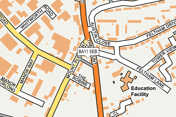
BA11 5EB lies on The Mount in Frome. BA11 5EB is located in the Frome East electoral ward, within the unitary authority of Somerset and the English Parliamentary constituency of Somerton and Frome. The Sub Integrated Care Board (ICB) Location is NHS Somerset ICB - 11X and the police force is Avon and Somerset. This postcode has been in use since January 1980.


GetTheData
Source: OS OpenMap – Local (Ordnance Survey)
Source: OS VectorMap District (Ordnance Survey)
Licence: Open Government Licence (requires attribution)
| Easting | 377681 |
| Northing | 146834 |
| Latitude | 51.220261 |
| Longitude | -2.320961 |
GetTheData
Source: Open Postcode Geo
Licence: Open Government Licence
| Street | The Mount |
| Town/City | Frome |
| Country | England |
| Postcode District | BA11 |
| ➜ BA11 open data dashboard ➜ See where BA11 is on a map ➜ Where is Frome? | |
GetTheData
Source: Land Registry Price Paid Data
Licence: Open Government Licence
Elevation or altitude of BA11 5EB as distance above sea level:
| Metres | Feet | |
|---|---|---|
| Elevation | 100m | 328ft |
Elevation is measured from the approximate centre of the postcode, to the nearest point on an OS contour line from OS Terrain 50, which has contour spacing of ten vertical metres.
➜ How high above sea level am I? Find the elevation of your current position using your device's GPS.
GetTheData
Source: Open Postcode Elevation
Licence: Open Government Licence
| Ward | Frome East |
| Constituency | Somerton And Frome |
GetTheData
Source: ONS Postcode Database
Licence: Open Government Licence
| January 2024 | Violence and sexual offences | On or near Mountsfield | 373m |
| January 2024 | Violence and sexual offences | On or near Longleat Close | 424m |
| September 2023 | Violence and sexual offences | On or near Mountsfield | 373m |
| ➜ The Mount crime map and outcomes | |||
GetTheData
Source: data.police.uk
Licence: Open Government Licence
| Hillside Avenue (Feltham Drive) | Little Keyford | 124m |
| Spar Shop (Culverhill) | Keyford | 140m |
| Spar Shop (Culverhill) | Keyford | 145m |
| Feltham Drive Flats (Austin Close) | Keyford | 228m |
| Stevens Lane (Culverhill) | Lower Keyford | 383m |
| Frome Station | 1.1km |
GetTheData
Source: NaPTAN
Licence: Open Government Licence
| Percentage of properties with Next Generation Access | 100.0% |
| Percentage of properties with Superfast Broadband | 100.0% |
| Percentage of properties with Ultrafast Broadband | 100.0% |
| Percentage of properties with Full Fibre Broadband | 0.0% |
Superfast Broadband is between 30Mbps and 300Mbps
Ultrafast Broadband is > 300Mbps
| Percentage of properties unable to receive 2Mbps | 0.0% |
| Percentage of properties unable to receive 5Mbps | 0.0% |
| Percentage of properties unable to receive 10Mbps | 0.0% |
| Percentage of properties unable to receive 30Mbps | 0.0% |
GetTheData
Source: Ofcom
Licence: Ofcom Terms of Use (requires attribution)
GetTheData
Source: ONS Postcode Database
Licence: Open Government Licence


➜ Get more ratings from the Food Standards Agency
GetTheData
Source: Food Standards Agency
Licence: FSA terms & conditions
| Last Collection | |||
|---|---|---|---|
| Location | Mon-Fri | Sat | Distance |
| The Mount | 17:30 | 12:00 | 136m |
| Locks Hill | 17:30 | 12:00 | 664m |
| Portway Post Office | 17:15 | 12:00 | 968m |
GetTheData
Source: Dracos
Licence: Creative Commons Attribution-ShareAlike
| Facility | Distance |
|---|---|
| The Fitness Studio Handlemaker Road, Frome Health and Fitness Gym | 450m |
| Mary Bailey Playing Field Park Road, Frome Outdoor Tennis Courts | 947m |
| Train Station Gym (Frome) Station Approach, Frome Health and Fitness Gym, Studio | 1.1km |
GetTheData
Source: Active Places
Licence: Open Government Licence
| School | Phase of Education | Distance |
|---|---|---|
| Christ Church First School Feltham Lane, Frome, BA11 5AJ | Primary | 143m |
| St John's Church of England Voluntary Aided First School, Frome Christchurch Street East, Frome, BA11 1QG | Primary | 938m |
| Avanti Park School Avanti Park School, Park Road, Frome, BA11 1EU | Middle deemed primary | 996m |
GetTheData
Source: Edubase
Licence: Open Government Licence
The below table lists the International Territorial Level (ITL) codes (formerly Nomenclature of Territorial Units for Statistics (NUTS) codes) and Local Administrative Units (LAU) codes for BA11 5EB:
| ITL 1 Code | Name |
|---|---|
| TLK | South West (England) |
| ITL 2 Code | Name |
| TLK2 | Dorset and Somerset |
| ITL 3 Code | Name |
| TLK23 | Somerset CC |
| LAU 1 Code | Name |
| E07000187 | Mendip |
GetTheData
Source: ONS Postcode Directory
Licence: Open Government Licence
The below table lists the Census Output Area (OA), Lower Layer Super Output Area (LSOA), and Middle Layer Super Output Area (MSOA) for BA11 5EB:
| Code | Name | |
|---|---|---|
| OA | E00147868 | |
| LSOA | E01029037 | Mendip 007C |
| MSOA | E02006053 | Mendip 007 |
GetTheData
Source: ONS Postcode Directory
Licence: Open Government Licence
| BA11 5EA | The Mount | 42m |
| BA11 5BA | Mount Pleasant | 57m |
| BA11 5AE | Feltham Drive | 96m |
| BA11 5BU | The Robins | 103m |
| BA11 5AD | Culverhill | 114m |
| BA11 5AU | Stonewall Terrace | 143m |
| BA11 5ED | The Mount | 149m |
| BA11 5AT | Hillside Avenue | 157m |
| BA11 5BB | Little Keyford Lane | 166m |
| BA11 5AF | Feltham Drive | 209m |
GetTheData
Source: Open Postcode Geo; Land Registry Price Paid Data
Licence: Open Government Licence