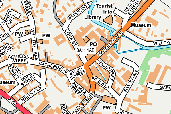
BA11 1AE is located in the Frome West electoral ward, within the unitary authority of Somerset and the English Parliamentary constituency of Somerton and Frome. The Sub Integrated Care Board (ICB) Location is NHS Somerset ICB - 11X and the police force is Avon and Somerset. This postcode has been in use since January 1980.


GetTheData
Source: OS OpenMap – Local (Ordnance Survey)
Source: OS VectorMap District (Ordnance Survey)
Licence: Open Government Licence (requires attribution)
| Easting | 377626 |
| Northing | 148059 |
| Latitude | 51.231274 |
| Longitude | -2.321825 |
GetTheData
Source: Open Postcode Geo
Licence: Open Government Licence
| Country | England |
| Postcode District | BA11 |
| ➜ BA11 open data dashboard ➜ See where BA11 is on a map ➜ Where is Frome? | |
GetTheData
Source: Land Registry Price Paid Data
Licence: Open Government Licence
Elevation or altitude of BA11 1AE as distance above sea level:
| Metres | Feet | |
|---|---|---|
| Elevation | 70m | 230ft |
Elevation is measured from the approximate centre of the postcode, to the nearest point on an OS contour line from OS Terrain 50, which has contour spacing of ten vertical metres.
➜ How high above sea level am I? Find the elevation of your current position using your device's GPS.
GetTheData
Source: Open Postcode Elevation
Licence: Open Government Licence
| Ward | Frome West |
| Constituency | Somerton And Frome |
GetTheData
Source: ONS Postcode Database
Licence: Open Government Licence
| January 2024 | Violence and sexual offences | On or near Parking Area | 117m |
| January 2024 | Criminal damage and arson | On or near Parking Area | 221m |
| January 2024 | Violence and sexual offences | On or near Garsdale | 440m |
| ➜ Get more crime data in our Crime section | |||
GetTheData
Source: data.police.uk
Licence: Open Government Licence
| Market Place | Frome | 42m |
| Market Place | Frome | 62m |
| Car Park | Frome | 146m |
| Memorial Theatre Complex (Christchurch Street West) | Frome | 278m |
| Christchurch (Christchurch Street East) | Frome | 283m |
| Frome Station | 0.9km |
GetTheData
Source: NaPTAN
Licence: Open Government Licence
GetTheData
Source: ONS Postcode Database
Licence: Open Government Licence


➜ Get more ratings from the Food Standards Agency
GetTheData
Source: Food Standards Agency
Licence: FSA terms & conditions
| Last Collection | |||
|---|---|---|---|
| Location | Mon-Fri | Sat | Distance |
| Portway Post Office | 17:15 | 12:00 | 490m |
| Locks Hill | 17:30 | 12:00 | 742m |
| The Mount | 17:30 | 12:00 | 1,091m |
GetTheData
Source: Dracos
Licence: Creative Commons Attribution-ShareAlike
| Facility | Distance |
|---|---|
| Curves (Frome) (Closed) Palmer Street, Frome Health and Fitness Gym | 110m |
| Mary Bailey Playing Field Park Road, Frome Outdoor Tennis Courts | 575m |
| Frome Cricket Club Rodden Road, Frome Grass Pitches | 797m |
GetTheData
Source: Active Places
Licence: Open Government Licence
| School | Phase of Education | Distance |
|---|---|---|
| St Louis Catholic Primary School, Frome Welshmill Lane, Select, BA11 3AP | Primary | 310m |
| Vallis First School Milk Street, Frome, BA11 3DB | Primary | 310m |
| St John's Church of England Voluntary Aided First School, Frome Christchurch Street East, Frome, BA11 1QG | Primary | 336m |
GetTheData
Source: Edubase
Licence: Open Government Licence
The below table lists the International Territorial Level (ITL) codes (formerly Nomenclature of Territorial Units for Statistics (NUTS) codes) and Local Administrative Units (LAU) codes for BA11 1AE:
| ITL 1 Code | Name |
|---|---|
| TLK | South West (England) |
| ITL 2 Code | Name |
| TLK2 | Dorset and Somerset |
| ITL 3 Code | Name |
| TLK23 | Somerset CC |
| LAU 1 Code | Name |
| E07000187 | Mendip |
GetTheData
Source: ONS Postcode Directory
Licence: Open Government Licence
The below table lists the Census Output Area (OA), Lower Layer Super Output Area (LSOA), and Middle Layer Super Output Area (MSOA) for BA11 1AE:
| Code | Name | |
|---|---|---|
| OA | E00147902 | |
| LSOA | E01029042 | Mendip 004C |
| MSOA | E02006050 | Mendip 004 |
GetTheData
Source: ONS Postcode Directory
Licence: Open Government Licence
| BA11 1DG | Bath Street | 57m |
| BA11 1AB | Market Place | 59m |
| BA11 1BU | Stony Street | 60m |
| BA11 1BL | Cork Street | 71m |
| BA11 1AN | Market Place | 72m |
| BA11 1BN | Cheap Street | 78m |
| BA11 1BS | Westway | 84m |
| BA11 1DL | Bath Street | 85m |
| BA11 1BY | Catherine Hill | 87m |
| BA11 1DR | Eagle Lane | 94m |
GetTheData
Source: Open Postcode Geo; Land Registry Price Paid Data
Licence: Open Government Licence