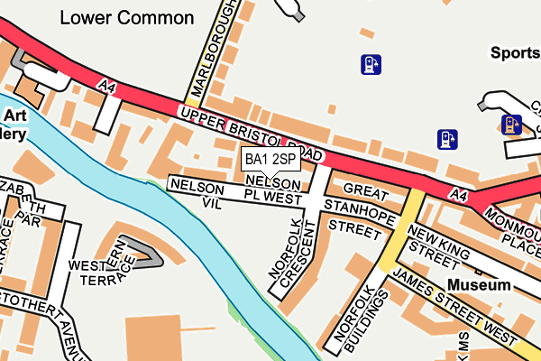
BA1 2SP lies on Nelson Place West in Bath. BA1 2SP is located in the Kingsmead electoral ward, within the unitary authority of Bath and North East Somerset and the English Parliamentary constituency of Bath. The Sub Integrated Care Board (ICB) Location is NHS Bath and North East Somerset, Swindon and Wiltshire ICB - 92 and the police force is Avon and Somerset. This postcode has been in use since June 2002.


GetTheData
Source: OS OpenMap – Local (Ordnance Survey)
Source: OS VectorMap District (Ordnance Survey)
Licence: Open Government Licence (requires attribution)
| Easting | 374326 |
| Northing | 164992 |
| Latitude | 51.383389 |
| Longitude | -2.370311 |
GetTheData
Source: Open Postcode Geo
Licence: Open Government Licence
| Street | Nelson Place West |
| Town/City | Bath |
| Country | England |
| Postcode District | BA1 |
➜ See where BA1 is on a map ➜ Where is Bath? | |
GetTheData
Source: Land Registry Price Paid Data
Licence: Open Government Licence
Elevation or altitude of BA1 2SP as distance above sea level:
| Metres | Feet | |
|---|---|---|
| Elevation | 20m | 66ft |
Elevation is measured from the approximate centre of the postcode, to the nearest point on an OS contour line from OS Terrain 50, which has contour spacing of ten vertical metres.
➜ How high above sea level am I? Find the elevation of your current position using your device's GPS.
GetTheData
Source: Open Postcode Elevation
Licence: Open Government Licence
| Ward | Kingsmead |
| Constituency | Bath |
GetTheData
Source: ONS Postcode Database
Licence: Open Government Licence
| Nile Street (Upper Bristol Road) | Kingsmead | 81m |
| Nile Street (Upper Bristol Road) | Kingsmead | 116m |
| Comfortable Place (Upper Bristol Road) | Lower Weston | 233m |
| Sainsbury's Car Park (Midland Bridge Road) | Kingsmead | 247m |
| Comfortable Place (Upper Bristol Road) | Lower Weston | 252m |
| Oldfield Park Station | 0.8km |
| Bath Spa Station | 1.1km |
| Freshford Station | 6.7km |
GetTheData
Source: NaPTAN
Licence: Open Government Licence
| Percentage of properties with Next Generation Access | 100.0% |
| Percentage of properties with Superfast Broadband | 100.0% |
| Percentage of properties with Ultrafast Broadband | 0.0% |
| Percentage of properties with Full Fibre Broadband | 0.0% |
Superfast Broadband is between 30Mbps and 300Mbps
Ultrafast Broadband is > 300Mbps
| Percentage of properties unable to receive 2Mbps | 0.0% |
| Percentage of properties unable to receive 5Mbps | 0.0% |
| Percentage of properties unable to receive 10Mbps | 0.0% |
| Percentage of properties unable to receive 30Mbps | 0.0% |
GetTheData
Source: Ofcom
Licence: Ofcom Terms of Use (requires attribution)
GetTheData
Source: ONS Postcode Database
Licence: Open Government Licence

➜ Get more ratings from the Food Standards Agency
GetTheData
Source: Food Standards Agency
Licence: FSA terms & conditions
| Last Collection | |||
|---|---|---|---|
| Location | Mon-Fri | Sat | Distance |
| Crescent Gardens | 17:30 | 13:00 | 116m |
| Charles Street | 17:15 | 12:45 | 364m |
| Marlborough Buildings | 17:30 | 11:30 | 424m |
GetTheData
Source: Dracos
Licence: Creative Commons Attribution-ShareAlike
| Risk of BA1 2SP flooding from rivers and sea | Low |
| ➜ BA1 2SP flood map | |
GetTheData
Source: Open Flood Risk by Postcode
Licence: Open Government Licence
The below table lists the International Territorial Level (ITL) codes (formerly Nomenclature of Territorial Units for Statistics (NUTS) codes) and Local Administrative Units (LAU) codes for BA1 2SP:
| ITL 1 Code | Name |
|---|---|
| TLK | South West (England) |
| ITL 2 Code | Name |
| TLK1 | Gloucestershire, Wiltshire and Bath/Bristol area |
| ITL 3 Code | Name |
| TLK12 | Bath and North East Somerset, North Somerset and South Gloucestershire |
| LAU 1 Code | Name |
| E06000022 | Bath and North East Somerset |
GetTheData
Source: ONS Postcode Directory
Licence: Open Government Licence
The below table lists the Census Output Area (OA), Lower Layer Super Output Area (LSOA), and Middle Layer Super Output Area (MSOA) for BA1 2SP:
| Code | Name | |
|---|---|---|
| OA | E00072772 | |
| LSOA | E01033080 | Bath and North East Somerset 009E |
| MSOA | E02002993 | Bath and North East Somerset 009 |
GetTheData
Source: ONS Postcode Directory
Licence: Open Government Licence
| BA1 2TH | Nelson Place West | 14m |
| BA1 2BA | Nelson Place West | 31m |
| BA1 2TL | Nelson Place West | 31m |
| BA1 3AA | St Georges Place | 31m |
| BA1 2AW | Nelson Lane | 41m |
| BA1 2NA | Crescent Gardens | 63m |
| BA1 3AB | St Georges Buildings | 65m |
| BA1 2AZ | Nile Street | 65m |
| BA1 2BD | Nelson Villas | 75m |
| BA1 2BG | Norfolk Crescent | 87m |
GetTheData
Source: Open Postcode Geo; Land Registry Price Paid Data
Licence: Open Government Licence