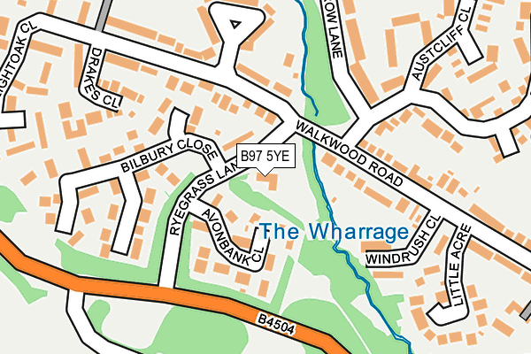
B97 5YE is located in the Crabbs Cross electoral ward, within the local authority district of Redditch and the English Parliamentary constituency of Redditch. The Sub Integrated Care Board (ICB) Location is NHS Herefordshire and Worcestershire ICB - 18C and the police force is West Mercia. This postcode has been in use since January 1993.


GetTheData
Source: OS OpenMap – Local (Ordnance Survey)
Source: OS VectorMap District (Ordnance Survey)
Licence: Open Government Licence (requires attribution)
| Easting | 403445 |
| Northing | 264618 |
| Latitude | 52.279697 |
| Longitude | -1.950925 |
GetTheData
Source: Open Postcode Geo
Licence: Open Government Licence
| Country | England |
| Postcode District | B97 |
| ➜ B97 open data dashboard ➜ See where B97 is on a map ➜ Where is Redditch? | |
GetTheData
Source: Land Registry Price Paid Data
Licence: Open Government Licence
Elevation or altitude of B97 5YE as distance above sea level:
| Metres | Feet | |
|---|---|---|
| Elevation | 120m | 394ft |
Elevation is measured from the approximate centre of the postcode, to the nearest point on an OS contour line from OS Terrain 50, which has contour spacing of ten vertical metres.
➜ How high above sea level am I? Find the elevation of your current position using your device's GPS.
GetTheData
Source: Open Postcode Elevation
Licence: Open Government Licence
| Ward | Crabbs Cross |
| Constituency | Redditch |
GetTheData
Source: ONS Postcode Database
Licence: Open Government Licence
| January 2024 | Anti-social behaviour | On or near Lightoak Close | 296m |
| January 2024 | Violence and sexual offences | On or near Ullapool Close | 467m |
| January 2024 | Violence and sexual offences | On or near Ullapool Close | 467m |
| ➜ Get more crime data in our Crime section | |||
GetTheData
Source: data.police.uk
Licence: Open Government Licence
| Rye Grass Lane | Walkwood | 89m |
| Rye Grass Lane | Walkwood | 97m |
| Boultons Lane (Walkwood Road) | Walkwood | 116m |
| Boultons Lane (Walkwood Road) | Walkwood | 116m |
| Little Acre (Walkwood Road) | Crabbs Cross | 221m |
| Redditch Station | 3km |
GetTheData
Source: NaPTAN
Licence: Open Government Licence
GetTheData
Source: ONS Postcode Database
Licence: Open Government Licence

➜ Get more ratings from the Food Standards Agency
GetTheData
Source: Food Standards Agency
Licence: FSA terms & conditions
| Last Collection | |||
|---|---|---|---|
| Location | Mon-Fri | Sat | Distance |
| Huntend Lane Didcot Close | 17:30 | 10:30 | 466m |
| Morton Lane | 17:45 | 10:30 | 635m |
| Crabbs Cross Post Office | 18:15 | 12:00 | 682m |
GetTheData
Source: Dracos
Licence: Creative Commons Attribution-ShareAlike
| Facility | Distance |
|---|---|
| Windmill Community Centre Ryegrass Lane, Redditch Sports Hall | 0m |
| St Augustines School Stonepits Lane, Redditch Sports Hall, Health and Fitness Gym, Grass Pitches | 665m |
| Oakenshaw Community Centre Castleditch Lane, Redditch Sports Hall | 980m |
GetTheData
Source: Active Places
Licence: Open Government Licence
| School | Phase of Education | Distance |
|---|---|---|
| Crabbs Cross Academy Evesham Road, Crabbs Cross, Redditch, B97 5JH | Primary | 618m |
| St Augustine's Catholic High School Stonepits Lane, Hunt End, Redditch, B97 5LX | Secondary | 676m |
| The Vaynor First School Tennyson Road, Headless Cross, Redditch, B97 5BL | Primary | 956m |
GetTheData
Source: Edubase
Licence: Open Government Licence
The below table lists the International Territorial Level (ITL) codes (formerly Nomenclature of Territorial Units for Statistics (NUTS) codes) and Local Administrative Units (LAU) codes for B97 5YE:
| ITL 1 Code | Name |
|---|---|
| TLG | West Midlands (England) |
| ITL 2 Code | Name |
| TLG1 | Herefordshire, Worcestershire and Warwickshire |
| ITL 3 Code | Name |
| TLG12 | Worcestershire CC |
| LAU 1 Code | Name |
| E07000236 | Redditch |
GetTheData
Source: ONS Postcode Directory
Licence: Open Government Licence
The below table lists the Census Output Area (OA), Lower Layer Super Output Area (LSOA), and Middle Layer Super Output Area (MSOA) for B97 5YE:
| Code | Name | |
|---|---|---|
| OA | E00164482 | |
| LSOA | E01032249 | Redditch 012D |
| MSOA | E02006732 | Redditch 012 |
GetTheData
Source: ONS Postcode Directory
Licence: Open Government Licence
| B97 5XR | Avonbank Close | 81m |
| B97 5NX | Walkwood Road | 88m |
| B97 5NS | Walkwood Road | 157m |
| B97 5JZ | Windrush Close | 158m |
| B97 5XW | Bilbury Close | 159m |
| B97 5XN | Bilbury Close | 175m |
| B97 5NU | Walkwood Road | 195m |
| B97 5PA | Woodberrow Lane | 199m |
| B97 5NT | Walkwood Crescent | 204m |
| B97 5NG | Drakes Close | 218m |
GetTheData
Source: Open Postcode Geo; Land Registry Price Paid Data
Licence: Open Government Licence