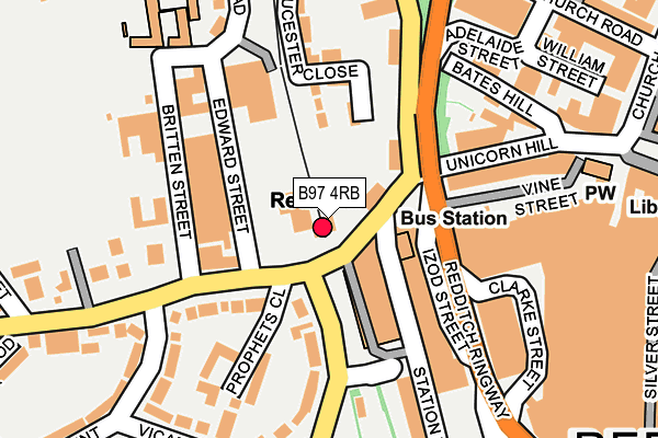
B97 4RB is located in the Abbey electoral ward, within the local authority district of Redditch and the English Parliamentary constituency of Redditch. The Sub Integrated Care Board (ICB) Location is NHS Herefordshire and Worcestershire ICB - 18C and the police force is West Mercia. This postcode has been in use since January 1980.


GetTheData
Source: OS OpenMap – Local (Ordnance Survey)
Source: OS VectorMap District (Ordnance Survey)
Licence: Open Government Licence (requires attribution)
| Easting | 403818 |
| Northing | 267580 |
| Latitude | 52.306324 |
| Longitude | -1.945426 |
GetTheData
Source: Open Postcode Geo
Licence: Open Government Licence
| Country | England |
| Postcode District | B97 |
| ➜ B97 open data dashboard ➜ See where B97 is on a map ➜ Where is Redditch? | |
GetTheData
Source: Land Registry Price Paid Data
Licence: Open Government Licence
Elevation or altitude of B97 4RB as distance above sea level:
| Metres | Feet | |
|---|---|---|
| Elevation | 110m | 361ft |
Elevation is measured from the approximate centre of the postcode, to the nearest point on an OS contour line from OS Terrain 50, which has contour spacing of ten vertical metres.
➜ How high above sea level am I? Find the elevation of your current position using your device's GPS.
GetTheData
Source: Open Postcode Elevation
Licence: Open Government Licence
| Ward | Abbey |
| Constituency | Redditch |
GetTheData
Source: ONS Postcode Database
Licence: Open Government Licence
| January 2024 | Criminal damage and arson | On or near Parking Area | 154m |
| November 2023 | Vehicle crime | On or near Vicarage Crescent | 472m |
| October 2023 | Violence and sexual offences | On or near Parking Area | 154m |
| ➜ Get more crime data in our Crime section | |||
GetTheData
Source: data.police.uk
Licence: Open Government Licence
| Redditch Railway Station (Station Approach Road) | Redditch | 27m |
| Hewell Road | Redditch | 98m |
| Britten Street (Windsor Street) | Redditch | 107m |
| Unicorn Hill | Redditch | 113m |
| Britten Street (Windsor Street) | Redditch | 115m |
| Redditch Station | 0km |
| Alvechurch Station | 4.7km |
GetTheData
Source: NaPTAN
Licence: Open Government Licence
GetTheData
Source: ONS Postcode Database
Licence: Open Government Licence


➜ Get more ratings from the Food Standards Agency
GetTheData
Source: Food Standards Agency
Licence: FSA terms & conditions
| Last Collection | |||
|---|---|---|---|
| Location | Mon-Fri | Sat | Distance |
| Edward St | 17:30 | 11:30 | 86m |
| Unicorn Hill | 18:30 | 258m | |
| Unicorn Hill Box | 18:30 | 12:30 | 263m |
GetTheData
Source: Dracos
Licence: Creative Commons Attribution-ShareAlike
| Facility | Distance |
|---|---|
| Puregym (Redditch) Silver Street, Redditch Health and Fitness Gym, Studio | 287m |
| Terry's Memorial Playing Field Bromsgrove Road, Bromsgrove Road, Redditch Grass Pitches | 393m |
| Choices Health Clubs (Redditch) (Closed) Alcester Street, Redditch Health and Fitness Gym, Studio | 404m |
GetTheData
Source: Active Places
Licence: Open Government Licence
| School | Phase of Education | Distance |
|---|---|---|
| Holyoakes Field First School Cookridge Close, Redditch, B97 6HF | Primary | 296m |
| Heart of Worcestershire College Peakman Campus, Peakman Street, Redditch, B98 8DW | 16 plus | 501m |
| Birchensale Middle School Bridley Moor Road, Redditch, B97 6HT | Middle deemed secondary | 599m |
GetTheData
Source: Edubase
Licence: Open Government Licence
The below table lists the International Territorial Level (ITL) codes (formerly Nomenclature of Territorial Units for Statistics (NUTS) codes) and Local Administrative Units (LAU) codes for B97 4RB:
| ITL 1 Code | Name |
|---|---|
| TLG | West Midlands (England) |
| ITL 2 Code | Name |
| TLG1 | Herefordshire, Worcestershire and Warwickshire |
| ITL 3 Code | Name |
| TLG12 | Worcestershire CC |
| LAU 1 Code | Name |
| E07000236 | Redditch |
GetTheData
Source: ONS Postcode Directory
Licence: Open Government Licence
The below table lists the Census Output Area (OA), Lower Layer Super Output Area (LSOA), and Middle Layer Super Output Area (MSOA) for B97 4RB:
| Code | Name | |
|---|---|---|
| OA | E00164392 | |
| LSOA | E01032224 | Redditch 004A |
| MSOA | E02006724 | Redditch 004 |
GetTheData
Source: ONS Postcode Directory
Licence: Open Government Licence
| B97 4QY | Bromsgrove Road | 100m |
| B97 4RD | Bromsgrove Road | 124m |
| B97 4QB | Plymouth Road | 150m |
| B97 4SD | Prophets Close | 171m |
| B97 4QR | Unicorn Hill | 172m |
| B97 6AE | Hewell Road | 182m |
| B97 4QU | Pound Yard | 191m |
| B97 4RE | Vicarage Crescent | 203m |
| B97 6HB | Elm Court | 207m |
| B97 6AH | Gloucester Close | 212m |
GetTheData
Source: Open Postcode Geo; Land Registry Price Paid Data
Licence: Open Government Licence