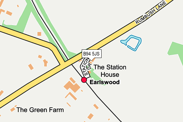
B94 5JS lies on Station Drive in Earlswood, Solihull. B94 5JS is located in the Blythe electoral ward, within the metropolitan district of Solihull and the English Parliamentary constituency of Meriden. The Sub Integrated Care Board (ICB) Location is NHS Birmingham and Solihull ICB - 15E and the police force is West Midlands. This postcode has been in use since January 1980.


GetTheData
Source: OS OpenMap – Local (Ordnance Survey)
Source: OS VectorMap District (Ordnance Survey)
Licence: Open Government Licence (requires attribution)
| Easting | 409559 |
| Northing | 274359 |
| Latitude | 52.367200 |
| Longitude | -1.861035 |
GetTheData
Source: Open Postcode Geo
Licence: Open Government Licence
| Street | Station Drive |
| Locality | Earlswood |
| Town/City | Solihull |
| Country | England |
| Postcode District | B94 |
➜ See where B94 is on a map | |
GetTheData
Source: Land Registry Price Paid Data
Licence: Open Government Licence
Elevation or altitude of B94 5JS as distance above sea level:
| Metres | Feet | |
|---|---|---|
| Elevation | 150m | 492ft |
Elevation is measured from the approximate centre of the postcode, to the nearest point on an OS contour line from OS Terrain 50, which has contour spacing of ten vertical metres.
➜ How high above sea level am I? Find the elevation of your current position using your device's GPS.
GetTheData
Source: Open Postcode Elevation
Licence: Open Government Licence
| Ward | Blythe |
| Constituency | Meriden |
GetTheData
Source: ONS Postcode Database
Licence: Open Government Licence
| Forshaw Heath Lane (Poolhead Lane) | Forshaw Heath | 917m |
| Rumbush Lane (Norton Lane) | Tidbury Green | 1,111m |
| Fulford Hall Road (Norton Lane) | Tidbury Green | 1,133m |
| Rumbush Lane (Norton Lane) | Tidbury Green | 1,142m |
| Norton Lane (Fulford Hall Rd) | Tidbury Green | 1,174m |
| Earlswood (West Midlands) Station | 0.1km |
| The Lakes Station | 1.4km |
| Wythall Station | 1.4km |
GetTheData
Source: NaPTAN
Licence: Open Government Licence
| Percentage of properties with Next Generation Access | 100.0% |
| Percentage of properties with Superfast Broadband | 100.0% |
| Percentage of properties with Ultrafast Broadband | 0.0% |
| Percentage of properties with Full Fibre Broadband | 0.0% |
Superfast Broadband is between 30Mbps and 300Mbps
Ultrafast Broadband is > 300Mbps
| Median download speed | 45.8Mbps |
| Average download speed | 37.6Mbps |
| Maximum download speed | 53.71Mbps |
| Median upload speed | 9.9Mbps |
| Average upload speed | 10.1Mbps |
| Maximum upload speed | 20.00Mbps |
| Percentage of properties unable to receive 2Mbps | 0.0% |
| Percentage of properties unable to receive 5Mbps | 0.0% |
| Percentage of properties unable to receive 10Mbps | 0.0% |
| Percentage of properties unable to receive 30Mbps | 0.0% |
GetTheData
Source: Ofcom
Licence: Ofcom Terms of Use (requires attribution)
GetTheData
Source: ONS Postcode Database
Licence: Open Government Licence

➜ Get more ratings from the Food Standards Agency
GetTheData
Source: Food Standards Agency
Licence: FSA terms & conditions
| Last Collection | |||
|---|---|---|---|
| Location | Mon-Fri | Sat | Distance |
| Fullford Hall Road | 17:00 | 12:30 | 1,181m |
| Gorsey Lane / Station Road Wytha | 17:15 | 11:30 | 1,335m |
| Grimes Hill Station | 17:15 | 11:30 | 1,432m |
GetTheData
Source: Dracos
Licence: Creative Commons Attribution-ShareAlike
The below table lists the International Territorial Level (ITL) codes (formerly Nomenclature of Territorial Units for Statistics (NUTS) codes) and Local Administrative Units (LAU) codes for B94 5JS:
| ITL 1 Code | Name |
|---|---|
| TLG | West Midlands (England) |
| ITL 2 Code | Name |
| TLG3 | West Midlands |
| ITL 3 Code | Name |
| TLG32 | Solihull |
| LAU 1 Code | Name |
| E08000029 | Solihull |
GetTheData
Source: ONS Postcode Directory
Licence: Open Government Licence
The below table lists the Census Output Area (OA), Lower Layer Super Output Area (LSOA), and Middle Layer Super Output Area (MSOA) for B94 5JS:
| Code | Name | |
|---|---|---|
| OA | E00051491 | |
| LSOA | E01032886 | Solihull 029G |
| MSOA | E02002109 | Solihull 029 |
GetTheData
Source: ONS Postcode Directory
Licence: Open Government Licence
| B94 5JU | Forshaw Heath Road | 315m |
| B94 5JT | Tanners Green Lane | 337m |
| B94 5JX | Forshaw Heath Road | 665m |
| B94 5JP | Wood Lane | 674m |
| B94 5LU | Fulford Hall Road | 746m |
| B94 5JZ | Forshaw Heath Road | 858m |
| B94 5LW | Rumbush Lane | 894m |
| B47 6BJ | Mill Lane | 912m |
| B94 5ET | Poolhead Lane | 939m |
| B47 6BH | Private Road | 1021m |
GetTheData
Source: Open Postcode Geo; Land Registry Price Paid Data
Licence: Open Government Licence