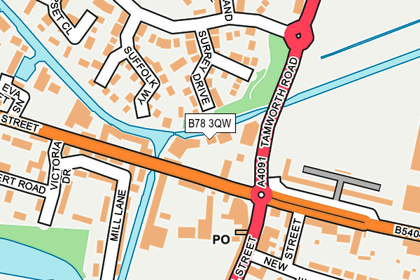
B78 3QW is located in the Fazeley electoral ward, within the local authority district of Lichfield and the English Parliamentary constituency of Tamworth. The Sub Integrated Care Board (ICB) Location is NHS Staffordshire and Stoke-on-Trent ICB - 05Q and the police force is Staffordshire. This postcode has been in use since January 1980.


GetTheData
Source: OS OpenMap – Local (Ordnance Survey)
Source: OS VectorMap District (Ordnance Survey)
Licence: Open Government Licence (requires attribution)
| Easting | 420410 |
| Northing | 301996 |
| Latitude | 52.615357 |
| Longitude | -1.699989 |
GetTheData
Source: Open Postcode Geo
Licence: Open Government Licence
| Country | England |
| Postcode District | B78 |
➜ See where B78 is on a map ➜ Where is Fazeley? | |
GetTheData
Source: Land Registry Price Paid Data
Licence: Open Government Licence
Elevation or altitude of B78 3QW as distance above sea level:
| Metres | Feet | |
|---|---|---|
| Elevation | 60m | 197ft |
Elevation is measured from the approximate centre of the postcode, to the nearest point on an OS contour line from OS Terrain 50, which has contour spacing of ten vertical metres.
➜ How high above sea level am I? Find the elevation of your current position using your device's GPS.
GetTheData
Source: Open Postcode Elevation
Licence: Open Government Licence
| Ward | Fazeley |
| Constituency | Tamworth |
GetTheData
Source: ONS Postcode Database
Licence: Open Government Licence
| The Square (Lichfield Street) | Fazeley | 63m |
| The Square (Tamworth Road) | Fazeley | 67m |
| St Pauls Church (Coleshill Road) | Fazeley | 237m |
| Tame Court (Atherstone Street) | Fazeley | 287m |
| Willowbank (Fazeley Rd) | Fazeley | 299m |
| Wilnecote (Staffs) Station | 1.5km |
| Tamworth Station | 2.6km |
| Tamworth High Level Station | 2.6km |
GetTheData
Source: NaPTAN
Licence: Open Government Licence
GetTheData
Source: ONS Postcode Database
Licence: Open Government Licence


➜ Get more ratings from the Food Standards Agency
GetTheData
Source: Food Standards Agency
Licence: FSA terms & conditions
| Last Collection | |||
|---|---|---|---|
| Location | Mon-Fri | Sat | Distance |
| Fazeley Post Office | 17:20 | 11:30 | 164m |
| Manor Drive / Fallow Road | 16:45 | 07:00 | 501m |
| Dosthill Post Office | 17:30 | 11:30 | 877m |
GetTheData
Source: Dracos
Licence: Creative Commons Attribution-ShareAlike
| Risk of B78 3QW flooding from rivers and sea | Low |
| ➜ B78 3QW flood map | |
GetTheData
Source: Open Flood Risk by Postcode
Licence: Open Government Licence
The below table lists the International Territorial Level (ITL) codes (formerly Nomenclature of Territorial Units for Statistics (NUTS) codes) and Local Administrative Units (LAU) codes for B78 3QW:
| ITL 1 Code | Name |
|---|---|
| TLG | West Midlands (England) |
| ITL 2 Code | Name |
| TLG2 | Shropshire and Staffordshire |
| ITL 3 Code | Name |
| TLG24 | Staffordshire CC |
| LAU 1 Code | Name |
| E07000194 | Lichfield |
GetTheData
Source: ONS Postcode Directory
Licence: Open Government Licence
The below table lists the Census Output Area (OA), Lower Layer Super Output Area (LSOA), and Middle Layer Super Output Area (MSOA) for B78 3QW:
| Code | Name | |
|---|---|---|
| OA | E00150332 | |
| LSOA | E01029504 | Lichfield 012D |
| MSOA | E02006157 | Lichfield 012 |
GetTheData
Source: ONS Postcode Directory
Licence: Open Government Licence
| B78 3XB | Surrey Drive | 98m |
| B78 3RJ | Tamworth Road | 114m |
| B78 3QN | Lichfield Street | 129m |
| B78 3XD | Suffolk Way | 145m |
| B78 3RB | Coleshill Street | 163m |
| B78 3RA | Coleshill Street | 173m |
| B78 3RE | Victory Terrace | 191m |
| B78 3RD | New Street | 194m |
| B78 3QH | Victoria Drive | 222m |
| B78 3QD | Mill Lane | 224m |
GetTheData
Source: Open Postcode Geo; Land Registry Price Paid Data
Licence: Open Government Licence