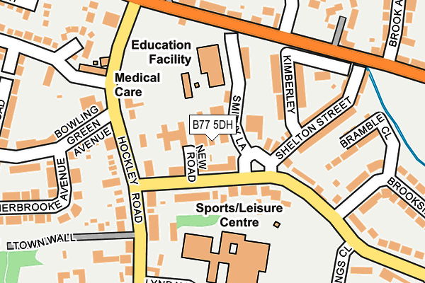
B77 5DH is located in the Wilnecote electoral ward, within the local authority district of Tamworth and the English Parliamentary constituency of Tamworth. The Sub Integrated Care Board (ICB) Location is NHS Staffordshire and Stoke-on-Trent ICB - 05Q and the police force is Staffordshire. This postcode has been in use since July 1983.


GetTheData
Source: OS OpenMap – Local (Ordnance Survey)
Source: OS VectorMap District (Ordnance Survey)
Licence: Open Government Licence (requires attribution)
| Easting | 422739 |
| Northing | 301045 |
| Latitude | 52.606733 |
| Longitude | -1.665648 |
GetTheData
Source: Open Postcode Geo
Licence: Open Government Licence
| Country | England |
| Postcode District | B77 |
| ➜ B77 open data dashboard ➜ See where B77 is on a map ➜ Where is Tamworth? | |
GetTheData
Source: Land Registry Price Paid Data
Licence: Open Government Licence
Elevation or altitude of B77 5DH as distance above sea level:
| Metres | Feet | |
|---|---|---|
| Elevation | 90m | 295ft |
Elevation is measured from the approximate centre of the postcode, to the nearest point on an OS contour line from OS Terrain 50, which has contour spacing of ten vertical metres.
➜ How high above sea level am I? Find the elevation of your current position using your device's GPS.
GetTheData
Source: Open Postcode Elevation
Licence: Open Government Licence
| Ward | Wilnecote |
| Constituency | Tamworth |
GetTheData
Source: ONS Postcode Database
Licence: Open Government Licence
| January 2024 | Violence and sexual offences | On or near Brook Avenue | 383m |
| October 2023 | Violence and sexual offences | On or near Sycamore | 359m |
| September 2023 | Vehicle crime | On or near Sycamore | 359m |
| ➜ Get more crime data in our Crime section | |||
GetTheData
Source: data.police.uk
Licence: Open Government Licence
| New Road (Tinkers Green Road) | Wilnecote | 51m |
| New Road (Tinkers Green Rd) | Wilnecote | 67m |
| Sycamore (Hockley Rd) | Wilnecote | 181m |
| Sycamore (Hockley Rd) | Wilnecote | 190m |
| Red Lion Ph (Watling St) | Wilnecote | 202m |
| Wilnecote (Staffs) Station | 1.1km |
| Tamworth High Level Station | 3.7km |
| Tamworth Station | 3.7km |
GetTheData
Source: NaPTAN
Licence: Open Government Licence
GetTheData
Source: ONS Postcode Database
Licence: Open Government Licence


➜ Get more ratings from the Food Standards Agency
GetTheData
Source: Food Standards Agency
Licence: FSA terms & conditions
| Last Collection | |||
|---|---|---|---|
| Location | Mon-Fri | Sat | Distance |
| Belgrave Post Office | 18:00 | 11:30 | 1,271m |
| Dosthill Post Office | 17:30 | 11:30 | 1,643m |
| Granada Services | 17:30 | 11:00 | 1,673m |
GetTheData
Source: Dracos
Licence: Creative Commons Attribution-ShareAlike
| Facility | Distance |
|---|---|
| Wilnecote Community Leisure Centre Tinkers Green Road, Wilnecote, Tamworth Sports Hall, Swimming Pool, Health and Fitness Gym, Grass Pitches, Studio | 165m |
| Ninefoot Playing Fields Ninefoot Lane, Wilnecote, Tamworth Grass Pitches | 361m |
| Wilnecote Sports & Recreational Association Brook Avenue, Wilnecote, Tamworth Grass Pitches | 527m |
GetTheData
Source: Active Places
Licence: Open Government Licence
| School | Phase of Education | Distance |
|---|---|---|
| Wilnecote Junior Academy Smithy Lane, Wilnecote, Tamworth, B77 5LA | Primary | 102m |
| The Wilnecote School Tinkers Green Road, Wilnecote, Tamworth, B77 5LF | Secondary | 165m |
| Heathfields Infant Academy Saxon Close, Wilnecote, Tamworth, B77 5LU | Primary | 537m |
GetTheData
Source: Edubase
Licence: Open Government Licence
The below table lists the International Territorial Level (ITL) codes (formerly Nomenclature of Territorial Units for Statistics (NUTS) codes) and Local Administrative Units (LAU) codes for B77 5DH:
| ITL 1 Code | Name |
|---|---|
| TLG | West Midlands (England) |
| ITL 2 Code | Name |
| TLG2 | Shropshire and Staffordshire |
| ITL 3 Code | Name |
| TLG24 | Staffordshire CC |
| LAU 1 Code | Name |
| E07000199 | Tamworth |
GetTheData
Source: ONS Postcode Directory
Licence: Open Government Licence
The below table lists the Census Output Area (OA), Lower Layer Super Output Area (LSOA), and Middle Layer Super Output Area (MSOA) for B77 5DH:
| Code | Name | |
|---|---|---|
| OA | E00152189 | |
| LSOA | E01032902 | Tamworth 010G |
| MSOA | E02006226 | Tamworth 010 |
GetTheData
Source: ONS Postcode Directory
Licence: Open Government Licence
| B77 5LA | Smithy Lane | 23m |
| B77 5DD | Tinkers Green Road | 41m |
| B77 5EB | Hockley Road | 91m |
| B77 5LB | Smithy Lane | 108m |
| B77 5LF | Tinkers Green Road | 135m |
| B77 5LE | Tinkers Green Road | 149m |
| B77 5LD | Kimberley | 155m |
| B77 5DB | Shelton Street | 179m |
| B77 5BP | Watling Street | 186m |
| B77 5EF | Hockley Road | 203m |
GetTheData
Source: Open Postcode Geo; Land Registry Price Paid Data
Licence: Open Government Licence