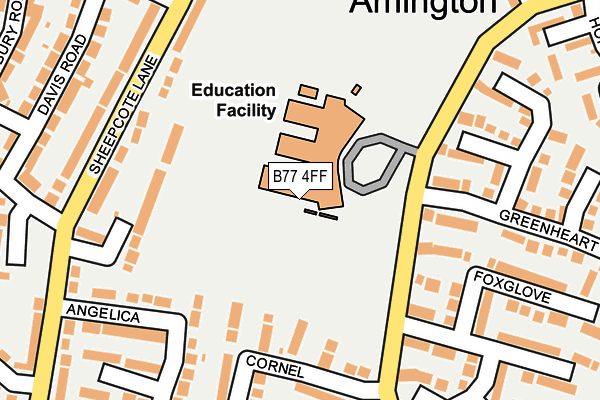
B77 4FF is located in the Glascote electoral ward, within the local authority district of Tamworth and the English Parliamentary constituency of Tamworth. The Sub Integrated Care Board (ICB) Location is NHS Staffordshire and Stoke-on-Trent ICB - 05Q and the police force is Staffordshire. This postcode has been in use since November 2011.


GetTheData
Source: OS OpenMap – Local (Ordnance Survey)
Source: OS VectorMap District (Ordnance Survey)
Licence: Open Government Licence (requires attribution)
| Easting | 422958 |
| Northing | 303686 |
| Latitude | 52.630448 |
| Longitude | -1.662240 |
GetTheData
Source: Open Postcode Geo
Licence: Open Government Licence
| Country | England |
| Postcode District | B77 |
| ➜ B77 open data dashboard ➜ See where B77 is on a map ➜ Where is Tamworth? | |
GetTheData
Source: Land Registry Price Paid Data
Licence: Open Government Licence
Elevation or altitude of B77 4FF as distance above sea level:
| Metres | Feet | |
|---|---|---|
| Elevation | 90m | 295ft |
Elevation is measured from the approximate centre of the postcode, to the nearest point on an OS contour line from OS Terrain 50, which has contour spacing of ten vertical metres.
➜ How high above sea level am I? Find the elevation of your current position using your device's GPS.
GetTheData
Source: Open Postcode Elevation
Licence: Open Government Licence
| Ward | Glascote |
| Constituency | Tamworth |
GetTheData
Source: ONS Postcode Database
Licence: Open Government Licence
| January 2024 | Criminal damage and arson | On or near Parking Area | 470m |
| November 2023 | Vehicle crime | On or near Hopleys Close | 456m |
| November 2023 | Other theft | On or near Hopleys Close | 456m |
| ➜ Get more crime data in our Crime section | |||
GetTheData
Source: data.police.uk
Licence: Open Government Licence
| Foxglove (Woodland Road) | Amington | 222m |
| Foxglove (Woodland Road) | Amington | 225m |
| Tudor Crescent (St George's Way) | Amington | 264m |
| Tudor Crescent (St Georges Way) | Amington | 272m |
| Canning Road (Sheepcote Lane) | Glascote | 345m |
| Tamworth High Level Station | 1.8km |
| Tamworth Station | 1.8km |
| Wilnecote (Staffs) Station | 2.5km |
GetTheData
Source: NaPTAN
Licence: Open Government Licence
GetTheData
Source: ONS Postcode Database
Licence: Open Government Licence


➜ Get more ratings from the Food Standards Agency
GetTheData
Source: Food Standards Agency
Licence: FSA terms & conditions
| Last Collection | |||
|---|---|---|---|
| Location | Mon-Fri | Sat | Distance |
| Pennymoor | 17:00 | 11:30 | 152m |
| Silver Link Post Office | 17:15 | 11:30 | 947m |
| Hamble | 16:00 | 11:30 | 1,714m |
GetTheData
Source: Dracos
Licence: Creative Commons Attribution-ShareAlike
| Facility | Distance |
|---|---|
| Landau-forte Academy Amington Woodland Road, Tamworth Health and Fitness Gym, Sports Hall, Studio, Artificial Grass Pitch, Outdoor Tennis Courts, Grass Pitches | 191m |
| Landau-forte Academy (Closed) Highfield Avenue, Tamworth Sports Hall, Swimming Pool, Grass Pitches | 213m |
| Florendine Primary School Florendine Street, Amington, Tamworth Grass Pitches | 505m |
GetTheData
Source: Active Places
Licence: Open Government Licence
| School | Phase of Education | Distance |
|---|---|---|
| Landau Forte Academy, Amington Woodland Road, Amington, Tamworth, B77 4FF | Secondary | 213m |
| Florendine Primary School Florendine Street, Amington, Tamworth, B77 3DD | Primary | 505m |
| The Woodlands Community Primary School Canning Road, Glascote, Tamworth, B77 3JX | Primary | 555m |
GetTheData
Source: Edubase
Licence: Open Government Licence
The below table lists the International Territorial Level (ITL) codes (formerly Nomenclature of Territorial Units for Statistics (NUTS) codes) and Local Administrative Units (LAU) codes for B77 4FF:
| ITL 1 Code | Name |
|---|---|
| TLG | West Midlands (England) |
| ITL 2 Code | Name |
| TLG2 | Shropshire and Staffordshire |
| ITL 3 Code | Name |
| TLG24 | Staffordshire CC |
| LAU 1 Code | Name |
| E07000199 | Tamworth |
GetTheData
Source: ONS Postcode Directory
Licence: Open Government Licence
The below table lists the Census Output Area (OA), Lower Layer Super Output Area (LSOA), and Middle Layer Super Output Area (MSOA) for B77 4FF:
| Code | Name | |
|---|---|---|
| OA | E00152075 | |
| LSOA | E01029844 | Tamworth 004E |
| MSOA | E02006220 | Tamworth 004 |
GetTheData
Source: ONS Postcode Directory
Licence: Open Government Licence
| B77 3JL | Longlands Drive | 162m |
| B77 4EF | Cornel | 181m |
| B77 3JN | Sheepcote Lane | 218m |
| B77 4NG | Greenheart | 222m |
| B77 4HY | Foxglove | 237m |
| B77 3JZ | Angelica | 239m |
| B77 3HP | Davis Road | 256m |
| B77 4EE | Clematis | 257m |
| B77 3JW | Sheepcote Lane | 266m |
| B77 3JD | Sheepcote Lane | 268m |
GetTheData
Source: Open Postcode Geo; Land Registry Price Paid Data
Licence: Open Government Licence