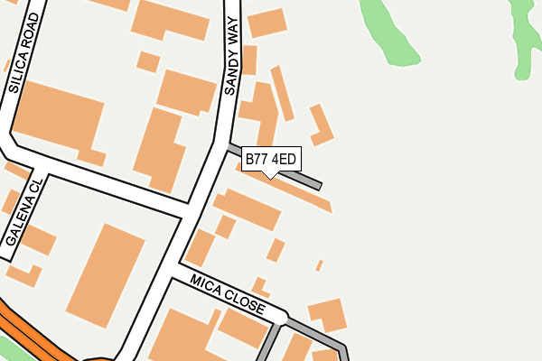
B77 4ED is located in the Amington electoral ward, within the local authority district of Tamworth and the English Parliamentary constituency of Tamworth. The Sub Integrated Care Board (ICB) Location is NHS Staffordshire and Stoke-on-Trent ICB - 05Q and the police force is Staffordshire. This postcode has been in use since March 1982.


GetTheData
Source: OS OpenMap – Local (Ordnance Survey)
Source: OS VectorMap District (Ordnance Survey)
Licence: Open Government Licence (requires attribution)
| Easting | 424022 |
| Northing | 302896 |
| Latitude | 52.623300 |
| Longitude | -1.646577 |
GetTheData
Source: Open Postcode Geo
Licence: Open Government Licence
| Country | England |
| Postcode District | B77 |
| ➜ B77 open data dashboard ➜ See where B77 is on a map ➜ Where is Tamworth? | |
GetTheData
Source: Land Registry Price Paid Data
Licence: Open Government Licence
Elevation or altitude of B77 4ED as distance above sea level:
| Metres | Feet | |
|---|---|---|
| Elevation | 110m | 361ft |
Elevation is measured from the approximate centre of the postcode, to the nearest point on an OS contour line from OS Terrain 50, which has contour spacing of ten vertical metres.
➜ How high above sea level am I? Find the elevation of your current position using your device's GPS.
GetTheData
Source: Open Postcode Elevation
Licence: Open Government Licence
| Ward | Amington |
| Constituency | Tamworth |
GetTheData
Source: ONS Postcode Database
Licence: Open Government Licence
| June 2023 | Possession of weapons | On or near Sandy Way | 463m |
| March 2023 | Drugs | On or near Sandy Way | 463m |
| August 2022 | Drugs | On or near Sandy Way | 463m |
| ➜ Get more crime data in our Crime section | |||
GetTheData
Source: data.police.uk
Licence: Open Government Licence
| Pennine Way (Glascote Rd) | Stonydelph | 286m |
| Pennine Way (Glascote Rd) | Stonydelph | 295m |
| Sandy Way (Glascote Rd) | Stonydelph | 308m |
| Sandy Way (Glascote Rd) | Stonydelph | 373m |
| Bridgens Transport (Sandy Way) | Amington | 422m |
| Polesworth Station | 2.5km |
| Wilnecote (Staffs) Station | 2.6km |
| Tamworth High Level Station | 3.1km |
GetTheData
Source: NaPTAN
Licence: Open Government Licence
GetTheData
Source: ONS Postcode Database
Licence: Open Government Licence


➜ Get more ratings from the Food Standards Agency
GetTheData
Source: Food Standards Agency
Licence: FSA terms & conditions
| Last Collection | |||
|---|---|---|---|
| Location | Mon-Fri | Sat | Distance |
| Malham Road / Lowforce | 18:00 | 11:30 | 852m |
| Silver Link Post Office | 17:15 | 11:30 | 1,171m |
| Pennymoor | 17:00 | 11:30 | 1,428m |
GetTheData
Source: Dracos
Licence: Creative Commons Attribution-ShareAlike
| Facility | Distance |
|---|---|
| Tamworth & District Indoor Bowls Club Eagle Drive, Tamworth Indoor Bowls | 564m |
| Tamworth Golf Centre Ltd (Closed) Eagle Drive, Tamworth Golf | 770m |
| Callis Cottage Playing Fields Litton, Stonydelph, Tamworth Grass Pitches | 781m |
GetTheData
Source: Active Places
Licence: Open Government Licence
| School | Phase of Education | Distance |
|---|---|---|
| Two Rivers Primary School Quince, Amington, Tamworth, B77 4EN | Not applicable | 761m |
| Amington Heath Primary School and Nursery Quince, Amington, Tamworth, B77 4EN | Primary | 843m |
| Stoneydelph Primary School Crowden Road, Wilnecote, Tamworth, B77 4LS | Primary | 879m |
GetTheData
Source: Edubase
Licence: Open Government Licence
The below table lists the International Territorial Level (ITL) codes (formerly Nomenclature of Territorial Units for Statistics (NUTS) codes) and Local Administrative Units (LAU) codes for B77 4ED:
| ITL 1 Code | Name |
|---|---|
| TLG | West Midlands (England) |
| ITL 2 Code | Name |
| TLG2 | Shropshire and Staffordshire |
| ITL 3 Code | Name |
| TLG24 | Staffordshire CC |
| LAU 1 Code | Name |
| E07000199 | Tamworth |
GetTheData
Source: ONS Postcode Directory
Licence: Open Government Licence
The below table lists the Census Output Area (OA), Lower Layer Super Output Area (LSOA), and Middle Layer Super Output Area (MSOA) for B77 4ED:
| Code | Name | |
|---|---|---|
| OA | E00151967 | |
| LSOA | E01029820 | Tamworth 003A |
| MSOA | E02006219 | Tamworth 003 |
GetTheData
Source: ONS Postcode Directory
Licence: Open Government Licence
| B77 4DR | Mica Close | 224m |
| B77 4AS | Galena Close | 320m |
| B77 4DT | Silica Road | 364m |
| B77 4DG | Ealingham | 373m |
| B77 4DN | Carlcroft | 388m |
| B77 4JG | Abberley | 391m |
| B77 4DQ | Ealingham | 415m |
| B77 4BS | Calder | 420m |
| B77 4RP | Amber Close | 420m |
| B77 4JS | Correen | 421m |
GetTheData
Source: Open Postcode Geo; Land Registry Price Paid Data
Licence: Open Government Licence