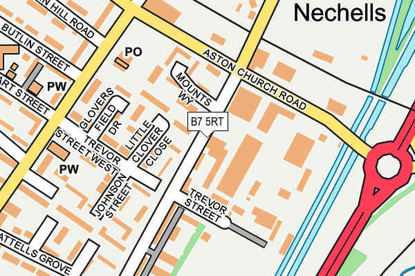
B7 5RT is located in the Nechells electoral ward, within the metropolitan district of Birmingham and the English Parliamentary constituency of Birmingham, Ladywood. The Sub Integrated Care Board (ICB) Location is NHS Birmingham and Solihull ICB - 15E and the police force is West Midlands. This postcode has been in use since January 1980.


GetTheData
Source: OS OpenMap – Local (Ordnance Survey)
Source: OS VectorMap District (Ordnance Survey)
Licence: Open Government Licence (requires attribution)
| Easting | 409361 |
| Northing | 288999 |
| Latitude | 52.498831 |
| Longitude | -1.863533 |
GetTheData
Source: Open Postcode Geo
Licence: Open Government Licence
| Country | England |
| Postcode District | B7 |
| ➜ B7 open data dashboard ➜ See where B7 is on a map ➜ Where is Birmingham? | |
GetTheData
Source: Land Registry Price Paid Data
Licence: Open Government Licence
Elevation or altitude of B7 5RT as distance above sea level:
| Metres | Feet | |
|---|---|---|
| Elevation | 100m | 328ft |
Elevation is measured from the approximate centre of the postcode, to the nearest point on an OS contour line from OS Terrain 50, which has contour spacing of ten vertical metres.
➜ How high above sea level am I? Find the elevation of your current position using your device's GPS.
GetTheData
Source: Open Postcode Elevation
Licence: Open Government Licence
| Ward | Nechells |
| Constituency | Birmingham, Ladywood |
GetTheData
Source: ONS Postcode Database
Licence: Open Government Licence
| June 2022 | Anti-social behaviour | On or near Mounts Way | 94m |
| June 2022 | Anti-social behaviour | On or near Trevor Street | 97m |
| June 2022 | Violence and sexual offences | On or near Little Clover Close | 102m |
| ➜ Get more crime data in our Crime section | |||
GetTheData
Source: data.police.uk
Licence: Open Government Licence
| Holborn Hill (Nechells Park Rd) | Nechells | 225m |
| Stuart St (Nechells Park Rd) | Saltley | 226m |
| Stuart St (Nechells Park Rd) | Saltley | 249m |
| Holborn Hill (Nechells Park Rd) | Nechells | 266m |
| Cattells Grove (Nechells Park Rd) | Saltley | 326m |
| Aston Station | 0.8km |
| Duddeston Station | 1.3km |
| Adderley Park Station | 1.8km |
GetTheData
Source: NaPTAN
Licence: Open Government Licence
GetTheData
Source: ONS Postcode Database
Licence: Open Government Licence

➜ Get more ratings from the Food Standards Agency
GetTheData
Source: Food Standards Agency
Licence: FSA terms & conditions
| Last Collection | |||
|---|---|---|---|
| Location | Mon-Fri | Sat | Distance |
| Nechells Park Road Post Office | 18:30 | 12:30 | 211m |
| Nechells Park Road /Stanley Road | 17:30 | 12:30 | 404m |
| Saltley | 17:30 | 11:30 | 761m |
GetTheData
Source: Dracos
Licence: Creative Commons Attribution-ShareAlike
| Facility | Distance |
|---|---|
| Virgin Active Club (Birmingham Star City) (Closed) Watson Road, Nechells, Birmingham Swimming Pool, Health and Fitness Gym, Studio | 881m |
| Goals (Birmingham Star City) Watson Road, Nechells, Birmingham Artificial Grass Pitch | 882m |
| Powerleague (Birmingham) Lichfield Road, Birmingham Artificial Grass Pitch | 1.1km |
GetTheData
Source: Active Places
Licence: Open Government Licence
| School | Phase of Education | Distance |
|---|---|---|
| St Clement's Church of England Academy Butlin Street, Nechells, Birmingham, B7 5NS | Primary | 332m |
| E-ACT Nechells Academy Eliot Street, Nechells, Birmingham, B7 5LB | Primary | 578m |
| St Joseph's Catholic Primary School Rocky Lane, Nechells, Birmingham, B7 5HA | Primary | 714m |
GetTheData
Source: Edubase
Licence: Open Government Licence
The below table lists the International Territorial Level (ITL) codes (formerly Nomenclature of Territorial Units for Statistics (NUTS) codes) and Local Administrative Units (LAU) codes for B7 5RT:
| ITL 1 Code | Name |
|---|---|
| TLG | West Midlands (England) |
| ITL 2 Code | Name |
| TLG3 | West Midlands |
| ITL 3 Code | Name |
| TLG31 | Birmingham |
| LAU 1 Code | Name |
| E08000025 | Birmingham |
GetTheData
Source: ONS Postcode Directory
Licence: Open Government Licence
The below table lists the Census Output Area (OA), Lower Layer Super Output Area (LSOA), and Middle Layer Super Output Area (MSOA) for B7 5RT:
| Code | Name | |
|---|---|---|
| OA | E00046663 | |
| LSOA | E01009201 | Birmingham 043A |
| MSOA | E02001869 | Birmingham 043 |
GetTheData
Source: ONS Postcode Directory
Licence: Open Government Licence
| B7 5RS | Little Clover Close | 84m |
| B7 5QD | Aston Church Road | 117m |
| B7 5RH | Mounts Way | 122m |
| B7 5RJ | Mount Street | 143m |
| B7 5RR | Trevor Street West | 151m |
| B7 5PX | Johnson Street | 171m |
| B7 5UB | Gloversfield Drive | 177m |
| B7 5RX | Aston Church Road | 179m |
| B7 5RL | Trevor Street West | 181m |
| B7 5PY | Nechells Park Road | 193m |
GetTheData
Source: Open Postcode Geo; Land Registry Price Paid Data
Licence: Open Government Licence