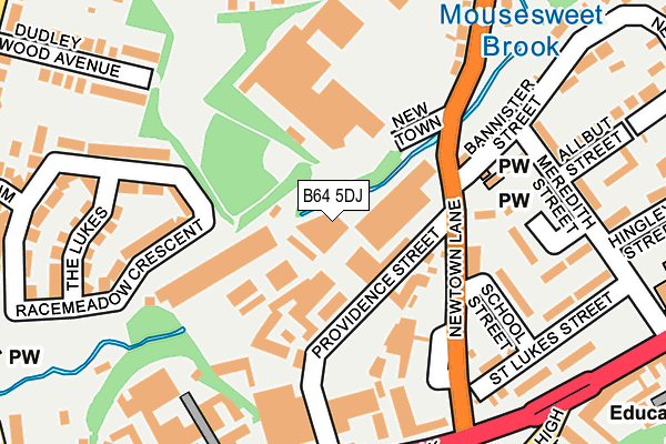
B64 5DJ is located in the Cradley Heath and Old Hill electoral ward, within the metropolitan district of Sandwell and the English Parliamentary constituency of Halesowen and Rowley Regis. The Sub Integrated Care Board (ICB) Location is NHS Black Country ICB - D2P2L and the police force is West Midlands. This postcode has been in use since March 1983.


GetTheData
Source: OS OpenMap – Local (Ordnance Survey)
Source: OS VectorMap District (Ordnance Survey)
Licence: Open Government Licence (requires attribution)
| Easting | 394555 |
| Northing | 286409 |
| Latitude | 52.475583 |
| Longitude | -2.081593 |
GetTheData
Source: Open Postcode Geo
Licence: Open Government Licence
| Country | England |
| Postcode District | B64 |
| ➜ B64 open data dashboard ➜ See where B64 is on a map ➜ Where is Cradley Heath? | |
GetTheData
Source: Land Registry Price Paid Data
Licence: Open Government Licence
Elevation or altitude of B64 5DJ as distance above sea level:
| Metres | Feet | |
|---|---|---|
| Elevation | 100m | 328ft |
Elevation is measured from the approximate centre of the postcode, to the nearest point on an OS contour line from OS Terrain 50, which has contour spacing of ten vertical metres.
➜ How high above sea level am I? Find the elevation of your current position using your device's GPS.
GetTheData
Source: Open Postcode Elevation
Licence: Open Government Licence
| Ward | Cradley Heath And Old Hill |
| Constituency | Halesowen And Rowley Regis |
GetTheData
Source: ONS Postcode Database
Licence: Open Government Licence
| November 2023 | Robbery | On or near Parking Area | 415m |
| November 2023 | Violence and sexual offences | On or near Parking Area | 415m |
| October 2023 | Vehicle crime | On or near Parking Area | 415m |
| ➜ Get more crime data in our Crime section | |||
GetTheData
Source: data.police.uk
Licence: Open Government Licence
| Spinners End (Upper High St) | Cradley Heath | 286m |
| Spinners End (Upper High St) | Cradley Heath | 290m |
| Tesco (High St) | Cradley Heath | 335m |
| Tesco (High St) | Cradley Heath | 338m |
| The Victoria (Dudley Wood Rd) | Dudley Wood | 339m |
| Cradley Heath Station | 0.9km |
| Old Hill Station | 1.8km |
| Lye (West Midlands) Station | 2.9km |
GetTheData
Source: NaPTAN
Licence: Open Government Licence
GetTheData
Source: ONS Postcode Database
Licence: Open Government Licence


➜ Get more ratings from the Food Standards Agency
GetTheData
Source: Food Standards Agency
Licence: FSA terms & conditions
| Last Collection | |||
|---|---|---|---|
| Location | Mon-Fri | Sat | Distance |
| St Peters Road | 17:30 | 11:00 | 97m |
| High St Opp Queen St | 17:30 | 12:00 | 306m |
| Dudley Wood Road | 17:30 | 11:00 | 374m |
GetTheData
Source: Dracos
Licence: Creative Commons Attribution-ShareAlike
| Facility | Distance |
|---|---|
| Dudley Wood Playing Fields Swallow Close, Dudley Grass Pitches, Cycling | 437m |
| Netherbrook Primary School Chester Road, Dudley Grass Pitches | 539m |
| Timbertree Primary School (Closed) Graingers Lane, Cradley Heath Grass Pitches | 598m |
GetTheData
Source: Active Places
Licence: Open Government Licence
| School | Phase of Education | Distance |
|---|---|---|
| Dudley Wood Primary School Dudley Wood Road, Dudley, DY2 0DB | Primary | 361m |
| Corngreaves Academy Plant Street, Cradley Heath, B64 6EZ | Primary | 425m |
| Netherbrook Primary School Chester Road, Netherton, Dudley, DY2 9RZ | Primary | 550m |
GetTheData
Source: Edubase
Licence: Open Government Licence
The below table lists the International Territorial Level (ITL) codes (formerly Nomenclature of Territorial Units for Statistics (NUTS) codes) and Local Administrative Units (LAU) codes for B64 5DJ:
| ITL 1 Code | Name |
|---|---|
| TLG | West Midlands (England) |
| ITL 2 Code | Name |
| TLG3 | West Midlands |
| ITL 3 Code | Name |
| TLG37 | Sandwell |
| LAU 1 Code | Name |
| E08000028 | Sandwell |
GetTheData
Source: ONS Postcode Directory
Licence: Open Government Licence
The below table lists the Census Output Area (OA), Lower Layer Super Output Area (LSOA), and Middle Layer Super Output Area (MSOA) for B64 5DJ:
| Code | Name | |
|---|---|---|
| OA | E00050373 | |
| LSOA | E01009953 | Sandwell 038A |
| MSOA | E02002080 | Sandwell 038 |
GetTheData
Source: ONS Postcode Directory
Licence: Open Government Licence
| B64 5EB | 100m | |
| B64 5EX | Crawley Walk | 167m |
| B64 5EJ | School Street | 170m |
| B64 5ET | Meredith Street | 198m |
| B64 5EU | Holly Bush Walk | 200m |
| DY2 0DH | The Lukes | 215m |
| DY2 9SS | Gold Crest Close | 215m |
| DY2 9SW | Cradley Road | 217m |
| B64 5EP | Meredith Street | 227m |
| B64 5EH | St Lukes Street | 233m |
GetTheData
Source: Open Postcode Geo; Land Registry Price Paid Data
Licence: Open Government Licence