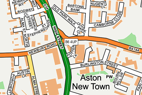
B6 4UP is located in the Newtown electoral ward, within the metropolitan district of Birmingham and the English Parliamentary constituency of Birmingham, Ladywood. The Sub Integrated Care Board (ICB) Location is NHS Birmingham and Solihull ICB - 15E and the police force is West Midlands. This postcode has been in use since January 1980.


GetTheData
Source: OS OpenMap – Local (Ordnance Survey)
Source: OS VectorMap District (Ordnance Survey)
Licence: Open Government Licence (requires attribution)
| Easting | 407218 |
| Northing | 289042 |
| Latitude | 52.499250 |
| Longitude | -1.895099 |
GetTheData
Source: Open Postcode Geo
Licence: Open Government Licence
| Country | England |
| Postcode District | B6 |
| ➜ B6 open data dashboard ➜ See where B6 is on a map ➜ Where is Birmingham? | |
GetTheData
Source: Land Registry Price Paid Data
Licence: Open Government Licence
Elevation or altitude of B6 4UP as distance above sea level:
| Metres | Feet | |
|---|---|---|
| Elevation | 110m | 361ft |
Elevation is measured from the approximate centre of the postcode, to the nearest point on an OS contour line from OS Terrain 50, which has contour spacing of ten vertical metres.
➜ How high above sea level am I? Find the elevation of your current position using your device's GPS.
GetTheData
Source: Open Postcode Elevation
Licence: Open Government Licence
| Ward | Newtown |
| Constituency | Birmingham, Ladywood |
GetTheData
Source: ONS Postcode Database
Licence: Open Government Licence
| June 2022 | Criminal damage and arson | On or near Newbury Road | 104m |
| June 2022 | Anti-social behaviour | On or near Parking Area | 122m |
| June 2022 | Public order | On or near Parking Area | 122m |
| ➜ Get more crime data in our Crime section | |||
GetTheData
Source: data.police.uk
Licence: Open Government Licence
| Swimming Baths (Newtown Row) | Newtown | 56m |
| Selston Rd (Park Lane) | Newtown | 79m |
| Swimming Baths (Newtown Row) | Newtown | 113m |
| Alma St (Newbury Rd) | Newtown | 130m |
| Selston Rd (Park Lane) | Newtown | 147m |
| St Paul's (Midland Metro Stop) (Livery Street) | Jewellery Quarter | 1,522m |
| Jewellery Quarter (Midland Metro Stop) (Vyse St Hockley) | Jewellery Quarter | 1,625m |
| Witton (West Midlands) Station | 1.6km |
| Jewellery Quarter Station | 1.6km |
| Aston Station | 1.7km |
GetTheData
Source: NaPTAN
Licence: Open Government Licence
GetTheData
Source: ONS Postcode Database
Licence: Open Government Licence


➜ Get more ratings from the Food Standards Agency
GetTheData
Source: Food Standards Agency
Licence: FSA terms & conditions
| Last Collection | |||
|---|---|---|---|
| Location | Mon-Fri | Sat | Distance |
| Newtown Post Office | 17:30 | 12:30 | 222m |
| Sixways Aston | 17:30 | 12:30 | 367m |
| Porchester Drive / Clifford St | 17:30 | 12:30 | 381m |
GetTheData
Source: Dracos
Licence: Creative Commons Attribution-ShareAlike
| Facility | Distance |
|---|---|
| Newtown Wellbeing Centre (Closed) Newtown Shopping Centre, Birmingham Swimming Pool, Health and Fitness Gym | 80m |
| Holte School Wheeler Street, Birmingham Sports Hall, Artificial Grass Pitch | 383m |
| The Lighthouse Young People's Centre Alma Way, Birmingham Sports Hall, Studio | 417m |
GetTheData
Source: Active Places
Licence: Open Government Licence
| School | Phase of Education | Distance |
|---|---|---|
| Newbury Independent School Unit 6, Cuckoo Wharf, 435 Lichfield Road, Aston, Birmingham, B6 7SS | Not applicable | 69m |
| Newtown Nursery School Hockley Close, Newtown, Birmingham, B19 2NS | Nursery | 422m |
| Chilwell Croft Academy Chilwell Croft, Newtown, Birmingham, B19 2QH | Primary | 443m |
GetTheData
Source: Edubase
Licence: Open Government Licence
The below table lists the International Territorial Level (ITL) codes (formerly Nomenclature of Territorial Units for Statistics (NUTS) codes) and Local Administrative Units (LAU) codes for B6 4UP:
| ITL 1 Code | Name |
|---|---|
| TLG | West Midlands (England) |
| ITL 2 Code | Name |
| TLG3 | West Midlands |
| ITL 3 Code | Name |
| TLG31 | Birmingham |
| LAU 1 Code | Name |
| E08000025 | Birmingham |
GetTheData
Source: ONS Postcode Directory
Licence: Open Government Licence
The below table lists the Census Output Area (OA), Lower Layer Super Output Area (LSOA), and Middle Layer Super Output Area (MSOA) for B6 4UP:
| Code | Name | |
|---|---|---|
| OA | E00045182 | |
| LSOA | E01033637 | Birmingham 041G |
| MSOA | E02001867 | Birmingham 041 |
GetTheData
Source: ONS Postcode Directory
Licence: Open Government Licence
| B6 4UN | Galena Way | 157m |
| B6 5EP | Bartons Bank | 173m |
| B6 5HY | Selston Road | 177m |
| B6 5HU | Selston Road | 200m |
| B6 5DL | Park Lane | 200m |
| B6 4UB | Burlington Street | 214m |
| B19 2RL | Alma Street | 223m |
| B19 2NW | Alma Street North | 233m |
| B6 5ER | Camborne Close | 234m |
| B6 5HZ | Nugent Close | 247m |
GetTheData
Source: Open Postcode Geo; Land Registry Price Paid Data
Licence: Open Government Licence