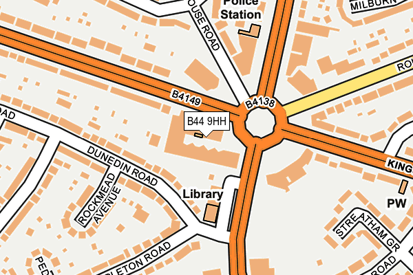
B44 9HH is located in the Oscott electoral ward, within the metropolitan district of Birmingham and the English Parliamentary constituency of Birmingham, Perry Barr. The Sub Integrated Care Board (ICB) Location is NHS Birmingham and Solihull ICB - 15E and the police force is West Midlands. This postcode has been in use since January 1980.


GetTheData
Source: OS OpenMap – Local (Ordnance Survey)
Source: OS VectorMap District (Ordnance Survey)
Licence: Open Government Licence (requires attribution)
| Easting | 407858 |
| Northing | 295002 |
| Latitude | 52.552822 |
| Longitude | -1.885532 |
GetTheData
Source: Open Postcode Geo
Licence: Open Government Licence
| Country | England |
| Postcode District | B44 |
| ➜ B44 open data dashboard ➜ See where B44 is on a map ➜ Where is Birmingham? | |
GetTheData
Source: Land Registry Price Paid Data
Licence: Open Government Licence
Elevation or altitude of B44 9HH as distance above sea level:
| Metres | Feet | |
|---|---|---|
| Elevation | 140m | 459ft |
Elevation is measured from the approximate centre of the postcode, to the nearest point on an OS contour line from OS Terrain 50, which has contour spacing of ten vertical metres.
➜ How high above sea level am I? Find the elevation of your current position using your device's GPS.
GetTheData
Source: Open Postcode Elevation
Licence: Open Government Licence
| Ward | Oscott |
| Constituency | Birmingham, Perry Barr |
GetTheData
Source: ONS Postcode Database
Licence: Open Government Licence
| January 2024 | Anti-social behaviour | On or near Supermarket | 213m |
| January 2024 | Other theft | On or near Supermarket | 213m |
| January 2024 | Public order | On or near Supermarket | 213m |
| ➜ Get more crime data in our Crime section | |||
GetTheData
Source: data.police.uk
Licence: Open Government Licence
| Kingstanding Circle Westside (Kings Rd) | Kingstanding | 34m |
| Kingstanding Circle Westside (Kings Rd) | Kingstanding | 65m |
| Dental Health Centre (Kingstanding Circle) | Kingstanding | 95m |
| Kingstanding Library (Kingstanding Circle) | Kingstanding | 97m |
| Kingstanding Circle (Kettlehouse Rd) | Kingstanding | 100m |
| Wylde Green Station | 3.8km |
| Hamstead (Birmingham) Station | 3.8km |
| Chester Road Station | 4.1km |
GetTheData
Source: NaPTAN
Licence: Open Government Licence
GetTheData
Source: ONS Postcode Database
Licence: Open Government Licence


➜ Get more ratings from the Food Standards Agency
GetTheData
Source: Food Standards Agency
Licence: FSA terms & conditions
| Last Collection | |||
|---|---|---|---|
| Location | Mon-Fri | Sat | Distance |
| Kingstanding Post Office | 17:30 | 12:30 | 41m |
| Colindale Road / Kings Road | 17:30 | 12:30 | 280m |
| Shady Lane / Gailey Croft | 17:45 | 12:30 | 479m |
GetTheData
Source: Dracos
Licence: Creative Commons Attribution-ShareAlike
| Facility | Distance |
|---|---|
| Cardinal Wiseman Catholic Technology College Old Oscott Hill, Birmingham Swimming Pool, Sports Hall, Grass Pitches | 413m |
| 610 Youth And Community Centre Kingstanding Road, Birmingham Artificial Grass Pitch, Sports Hall, Studio | 601m |
| Maryvale Catholic Primary School Old Oscott Hill, Birmingham Grass Pitches | 699m |
GetTheData
Source: Active Places
Licence: Open Government Licence
| School | Phase of Education | Distance |
|---|---|---|
| Cardinal Wiseman Catholic School Old Oscott Hill, Kingstanding, Birmingham, B44 9SR | Secondary | 502m |
| Kingsland Primary School (NC) Bandywood Crescent, Birmingham, B44 9NA | Primary | 550m |
| TLG North Birmingham 240-244 Lozells Road, Lozells, Kingstanding, Birmingham, B19 1NP | Not applicable | 602m |
GetTheData
Source: Edubase
Licence: Open Government Licence
The below table lists the International Territorial Level (ITL) codes (formerly Nomenclature of Territorial Units for Statistics (NUTS) codes) and Local Administrative Units (LAU) codes for B44 9HH:
| ITL 1 Code | Name |
|---|---|
| TLG | West Midlands (England) |
| ITL 2 Code | Name |
| TLG3 | West Midlands |
| ITL 3 Code | Name |
| TLG31 | Birmingham |
| LAU 1 Code | Name |
| E08000025 | Birmingham |
GetTheData
Source: ONS Postcode Directory
Licence: Open Government Licence
The below table lists the Census Output Area (OA), Lower Layer Super Output Area (LSOA), and Middle Layer Super Output Area (MSOA) for B44 9HH:
| Code | Name | |
|---|---|---|
| OA | E00046804 | |
| LSOA | E01009221 | Birmingham 007A |
| MSOA | E02001833 | Birmingham 007 |
GetTheData
Source: ONS Postcode Directory
Licence: Open Government Licence
| B44 9DN | Dunedin Road | 99m |
| B44 9SU | Kingstanding Road | 130m |
| B44 9DP | Dunedin Road | 136m |
| B44 9JH | Kettlehouse Road | 144m |
| B44 9HL | Kings Road | 148m |
| B44 9RT | Kingstanding Road | 194m |
| B44 9DR | Rockmead Avenue | 208m |
| B44 9BU | Templeton Road | 217m |
| B44 0UH | Kings Road | 217m |
| B44 9LN | Dormington Road | 226m |
GetTheData
Source: Open Postcode Geo; Land Registry Price Paid Data
Licence: Open Government Licence