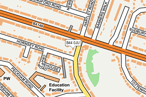
B44 0JU lies on Finchley Road in Birmingham. B44 0JU is located in the Kingstanding electoral ward, within the metropolitan district of Birmingham and the English Parliamentary constituency of Birmingham, Erdington. The Sub Integrated Care Board (ICB) Location is NHS Birmingham and Solihull ICB - 15E and the police force is West Midlands. This postcode has been in use since January 1980.


GetTheData
Source: OS OpenMap – Local (Ordnance Survey)
Source: OS VectorMap District (Ordnance Survey)
Licence: Open Government Licence (requires attribution)
| Easting | 408618 |
| Northing | 294757 |
| Latitude | 52.550592 |
| Longitude | -1.874335 |
GetTheData
Source: Open Postcode Geo
Licence: Open Government Licence
| Street | Finchley Road |
| Town/City | Birmingham |
| Country | England |
| Postcode District | B44 |
| ➜ B44 open data dashboard ➜ See where B44 is on a map ➜ Where is Birmingham? | |
GetTheData
Source: Land Registry Price Paid Data
Licence: Open Government Licence
Elevation or altitude of B44 0JU as distance above sea level:
| Metres | Feet | |
|---|---|---|
| Elevation | 130m | 427ft |
Elevation is measured from the approximate centre of the postcode, to the nearest point on an OS contour line from OS Terrain 50, which has contour spacing of ten vertical metres.
➜ How high above sea level am I? Find the elevation of your current position using your device's GPS.
GetTheData
Source: Open Postcode Elevation
Licence: Open Government Licence
| Ward | Kingstanding |
| Constituency | Birmingham, Erdington |
GetTheData
Source: ONS Postcode Database
Licence: Open Government Licence
| June 2022 | Criminal damage and arson | On or near Kings Road | 49m |
| June 2022 | Vehicle crime | On or near Kings Road | 49m |
| June 2022 | Violence and sexual offences | On or near Kings Road | 49m |
| ➜ Finchley Road crime map and outcomes | |||
GetTheData
Source: data.police.uk
Licence: Open Government Licence
| Hornsey Rd (Finchley Rd) | Kingstanding | 14m |
| Hornsey Rd (Finchley Rd) | Kingstanding | 25m |
| Finchley Rd (Kings Rd) | Kingstanding | 77m |
| Finchley Rd (Kings Rd) | Kingstanding | 90m |
| Sidcup Rd (Finchley Rd) | Warren Farm | 231m |
| Wylde Green Station | 3km |
| Chester Road Station | 3.3km |
| Erdington Station | 3.4km |
GetTheData
Source: NaPTAN
Licence: Open Government Licence
| Percentage of properties with Next Generation Access | 100.0% |
| Percentage of properties with Superfast Broadband | 100.0% |
| Percentage of properties with Ultrafast Broadband | 100.0% |
| Percentage of properties with Full Fibre Broadband | 100.0% |
Superfast Broadband is between 30Mbps and 300Mbps
Ultrafast Broadband is > 300Mbps
| Percentage of properties unable to receive 2Mbps | 0.0% |
| Percentage of properties unable to receive 5Mbps | 0.0% |
| Percentage of properties unable to receive 10Mbps | 0.0% |
| Percentage of properties unable to receive 30Mbps | 0.0% |
GetTheData
Source: Ofcom
Licence: Ofcom Terms of Use (requires attribution)
GetTheData
Source: ONS Postcode Database
Licence: Open Government Licence


➜ Get more ratings from the Food Standards Agency
GetTheData
Source: Food Standards Agency
Licence: FSA terms & conditions
| Last Collection | |||
|---|---|---|---|
| Location | Mon-Fri | Sat | Distance |
| Kings Road / Hartley Road | 17:30 | 12:30 | 80m |
| Hatcham Road / Kings Road | 17:30 | 12:30 | 379m |
| Newstead Road / Colindale Road | 17:30 | 12:30 | 409m |
GetTheData
Source: Dracos
Licence: Creative Commons Attribution-ShareAlike
| Facility | Distance |
|---|---|
| 610 Youth And Community Centre Kingstanding Road, Birmingham Artificial Grass Pitch, Sports Hall, Studio | 842m |
| New Oscott Primary School Markham Road, Sutton Coldfield Grass Pitches | 875m |
| Sutton Park Primary School Coppice View Road, Sutton Coldfield Grass Pitches | 892m |
GetTheData
Source: Active Places
Licence: Open Government Licence
| School | Phase of Education | Distance |
|---|---|---|
| Kings Rise Academy Hornsey Road, Kingstanding, Birmingham, B44 0JL | Primary | 147m |
| Twickenham Primary School Twickenham Road, Kingstanding, Birmingham, B44 0NR | Primary | 683m |
| The Bridge School Coppice View Road, Sutton Coldfield, Birmingham, B73 6UE | Not applicable | 778m |
GetTheData
Source: Edubase
Licence: Open Government Licence
The below table lists the International Territorial Level (ITL) codes (formerly Nomenclature of Territorial Units for Statistics (NUTS) codes) and Local Administrative Units (LAU) codes for B44 0JU:
| ITL 1 Code | Name |
|---|---|
| TLG | West Midlands (England) |
| ITL 2 Code | Name |
| TLG3 | West Midlands |
| ITL 3 Code | Name |
| TLG31 | Birmingham |
| LAU 1 Code | Name |
| E08000025 | Birmingham |
GetTheData
Source: ONS Postcode Directory
Licence: Open Government Licence
The below table lists the Census Output Area (OA), Lower Layer Super Output Area (LSOA), and Middle Layer Super Output Area (MSOA) for B44 0JU:
| Code | Name | |
|---|---|---|
| OA | E00046312 | |
| LSOA | E01009128 | Birmingham 011B |
| MSOA | E02001837 | Birmingham 011 |
GetTheData
Source: ONS Postcode Directory
Licence: Open Government Licence
| B44 0RZ | Kings Road | 61m |
| B44 0JX | Finchley Road | 85m |
| B44 0JL | Hornsey Road | 89m |
| B44 0TE | Kings Road | 94m |
| B44 0JT | Hornsey Road | 97m |
| B44 0JJ | Finchley Road | 111m |
| B44 0JW | Cranehouse Road | 126m |
| B44 0RS | Longford Road | 129m |
| B44 0UL | Kings Road | 160m |
| B44 0SA | Kings Road | 176m |
GetTheData
Source: Open Postcode Geo; Land Registry Price Paid Data
Licence: Open Government Licence