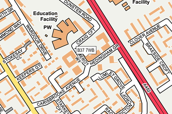
B37 7WB is located in the Chelmsley Wood electoral ward, within the metropolitan district of Solihull and the English Parliamentary constituency of Meriden. The Sub Integrated Care Board (ICB) Location is NHS Birmingham and Solihull ICB - 15E and the police force is West Midlands. This postcode has been in use since November 2015.


GetTheData
Source: OS OpenMap – Local (Ordnance Survey)
Source: OS VectorMap District (Ordnance Survey)
Licence: Open Government Licence (requires attribution)
| Easting | 418527 |
| Northing | 286688 |
| Latitude | 52.477824 |
| Longitude | -1.728641 |
GetTheData
Source: Open Postcode Geo
Licence: Open Government Licence
| Country | England |
| Postcode District | B37 |
| ➜ B37 open data dashboard ➜ See where B37 is on a map ➜ Where is Birmingham? | |
GetTheData
Source: Land Registry Price Paid Data
Licence: Open Government Licence
Elevation or altitude of B37 7WB as distance above sea level:
| Metres | Feet | |
|---|---|---|
| Elevation | 100m | 328ft |
Elevation is measured from the approximate centre of the postcode, to the nearest point on an OS contour line from OS Terrain 50, which has contour spacing of ten vertical metres.
➜ How high above sea level am I? Find the elevation of your current position using your device's GPS.
GetTheData
Source: Open Postcode Elevation
Licence: Open Government Licence
| Ward | Chelmsley Wood |
| Constituency | Meriden |
GetTheData
Source: ONS Postcode Database
Licence: Open Government Licence
| January 2024 | Vehicle crime | On or near Clover Avenue | 367m |
| January 2024 | Vehicle crime | On or near Arbor Way | 464m |
| December 2023 | Criminal damage and arson | On or near Clover Avenue | 367m |
| ➜ Get more crime data in our Crime section | |||
GetTheData
Source: data.police.uk
Licence: Open Government Licence
| Hedingham Grove (Craig Croft) | Chelmsley Wood | 48m |
| Hedingham Grove (Craig Croft) | Chelmsley Wood | 68m |
| Craig Croft (Dunster Rd) | Chelmsley Wood | 149m |
| Craig Croft (Dunster Rd) | Chelmsley Wood | 154m |
| Keepers Lodge (Chelmsley Rd) | Chelmsley Wood | 199m |
| Marston Green Station | 2.2km |
| Birmingham International Station | 3km |
| Lea Hall Station | 3.9km |
GetTheData
Source: NaPTAN
Licence: Open Government Licence
| Percentage of properties with Next Generation Access | 100.0% |
| Percentage of properties with Superfast Broadband | 100.0% |
| Percentage of properties with Ultrafast Broadband | 0.0% |
| Percentage of properties with Full Fibre Broadband | 0.0% |
Superfast Broadband is between 30Mbps and 300Mbps
Ultrafast Broadband is > 300Mbps
| Percentage of properties unable to receive 2Mbps | 0.0% |
| Percentage of properties unable to receive 5Mbps | 0.0% |
| Percentage of properties unable to receive 10Mbps | 0.0% |
| Percentage of properties unable to receive 30Mbps | 0.0% |
GetTheData
Source: Ofcom
Licence: Ofcom Terms of Use (requires attribution)
GetTheData
Source: ONS Postcode Database
Licence: Open Government Licence


➜ Get more ratings from the Food Standards Agency
GetTheData
Source: Food Standards Agency
Licence: FSA terms & conditions
| Last Collection | |||
|---|---|---|---|
| Location | Mon-Fri | Sat | Distance |
| Lyecroft Avenue / Yorkminster | 17:15 | 12:00 | 566m |
| Winchester Drive Near Chinches | 17:15 | 12:30 | 964m |
| Waterside Centre | 18:30 | 12:00 | 1,294m |
GetTheData
Source: Dracos
Licence: Creative Commons Attribution-ShareAlike
| Facility | Distance |
|---|---|
| Forum Health Club (Closed) Craig Croft, Birmingham Health and Fitness Gym | 64m |
| Heartbeats Fitness Centre (Closed) Bridge Road, Alum Rock, Birmingham Health and Fitness Gym | 82m |
| Bluebell Recreation Ground Bluebell Drive, Birmingham Grass Pitches | 497m |
GetTheData
Source: Active Places
Licence: Open Government Licence
| School | Phase of Education | Distance |
|---|---|---|
| Bishop Wilson Church of England Primary School 10 Craig Croft, Chelmund's Cross, Chelmsley Wood, Birmingham, B37 7TR | Primary | 111m |
| Windy Arbor Primary School Woodlands Way, Chelmsley Wood, Birmingham, B37 6RN | Primary | 335m |
| Coleshill Heath School Lime Grove, Chelmsley Wood, Birmingham, B37 7PY | Primary | 740m |
GetTheData
Source: Edubase
Licence: Open Government Licence
The below table lists the International Territorial Level (ITL) codes (formerly Nomenclature of Territorial Units for Statistics (NUTS) codes) and Local Administrative Units (LAU) codes for B37 7WB:
| ITL 1 Code | Name |
|---|---|
| TLG | West Midlands (England) |
| ITL 2 Code | Name |
| TLG3 | West Midlands |
| ITL 3 Code | Name |
| TLG32 | Solihull |
| LAU 1 Code | Name |
| E08000029 | Solihull |
GetTheData
Source: ONS Postcode Directory
Licence: Open Government Licence
The below table lists the Census Output Area (OA), Lower Layer Super Output Area (LSOA), and Middle Layer Super Output Area (MSOA) for B37 7WB:
| Code | Name | |
|---|---|---|
| OA | E00051207 | |
| LSOA | E01010130 | Solihull 008E |
| MSOA | E02002088 | Solihull 008 |
GetTheData
Source: ONS Postcode Directory
Licence: Open Government Licence
| B37 7TR | Craig Croft | 73m |
| B37 7SG | Carisbrooke Avenue | 92m |
| B37 7SB | Long Ley Walk | 138m |
| B37 7SD | Long Ley Walk | 148m |
| B37 7TN | Hedingham Grove | 150m |
| B37 7SW | Keepers Gate | 156m |
| B37 7TJ | Lumley Grove | 166m |
| B37 7UA | Wardour Drive | 173m |
| B37 7SH | Starkey Croft | 181m |
| B37 7TL | Dunster Road | 213m |
GetTheData
Source: Open Postcode Geo; Land Registry Price Paid Data
Licence: Open Government Licence