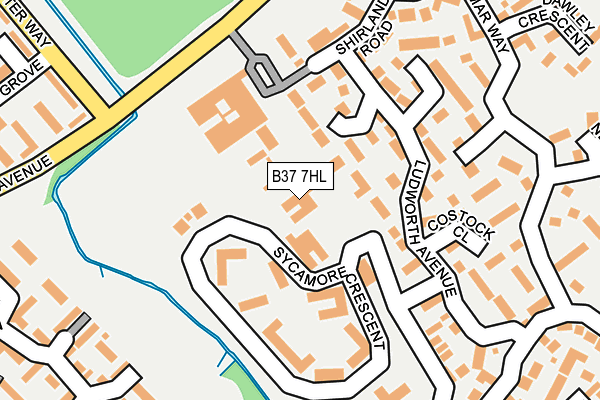
B37 7HL is located in the Bickenhill electoral ward, within the metropolitan district of Solihull and the English Parliamentary constituency of Meriden. The Sub Integrated Care Board (ICB) Location is NHS Birmingham and Solihull ICB - 15E and the police force is West Midlands. This postcode has been in use since January 1980.


GetTheData
Source: OS OpenMap – Local (Ordnance Survey)
Source: OS VectorMap District (Ordnance Survey)
Licence: Open Government Licence (requires attribution)
| Easting | 417480 |
| Northing | 285949 |
| Latitude | 52.471200 |
| Longitude | -1.744102 |
GetTheData
Source: Open Postcode Geo
Licence: Open Government Licence
| Country | England |
| Postcode District | B37 |
| ➜ B37 open data dashboard ➜ See where B37 is on a map ➜ Where is Birmingham? | |
GetTheData
Source: Land Registry Price Paid Data
Licence: Open Government Licence
Elevation or altitude of B37 7HL as distance above sea level:
| Metres | Feet | |
|---|---|---|
| Elevation | 90m | 295ft |
Elevation is measured from the approximate centre of the postcode, to the nearest point on an OS contour line from OS Terrain 50, which has contour spacing of ten vertical metres.
➜ How high above sea level am I? Find the elevation of your current position using your device's GPS.
GetTheData
Source: Open Postcode Elevation
Licence: Open Government Licence
| Ward | Bickenhill |
| Constituency | Meriden |
GetTheData
Source: ONS Postcode Database
Licence: Open Government Licence
| January 2024 | Bicycle theft | On or near Wavers Marston | 310m |
| January 2024 | Vehicle crime | On or near Lincoln Grove | 322m |
| January 2024 | Violence and sexual offences | On or near Radlow Crescent | 423m |
| ➜ Get more crime data in our Crime section | |||
GetTheData
Source: data.police.uk
Licence: Open Government Licence
| Gloucester Way (Moorend Ave) | Marston Green | 192m |
| Gloucester Way (Moorend Ave) | Marston Green | 199m |
| Walnut Close (Berwicks Lane) | Chelmsley Wood | 375m |
| Walnut Close (Berwicks Lane) | Chelmsley Wood | 377m |
| Winchester Drive (Moorend Ave) | Chelmsley Wood | 432m |
| Marston Green Station | 0.9km |
| Birmingham International Station | 2.6km |
| Lea Hall Station | 3km |
GetTheData
Source: NaPTAN
Licence: Open Government Licence
| Percentage of properties with Next Generation Access | 100.0% |
| Percentage of properties with Superfast Broadband | 100.0% |
| Percentage of properties with Ultrafast Broadband | 0.0% |
| Percentage of properties with Full Fibre Broadband | 0.0% |
Superfast Broadband is between 30Mbps and 300Mbps
Ultrafast Broadband is > 300Mbps
| Percentage of properties unable to receive 2Mbps | 0.0% |
| Percentage of properties unable to receive 5Mbps | 0.0% |
| Percentage of properties unable to receive 10Mbps | 0.0% |
| Percentage of properties unable to receive 30Mbps | 0.0% |
GetTheData
Source: Ofcom
Licence: Ofcom Terms of Use (requires attribution)
GetTheData
Source: ONS Postcode Database
Licence: Open Government Licence


➜ Get more ratings from the Food Standards Agency
GetTheData
Source: Food Standards Agency
Licence: FSA terms & conditions
| Last Collection | |||
|---|---|---|---|
| Location | Mon-Fri | Sat | Distance |
| Moorend Avenue | 17:15 | 12:30 | 397m |
| Winchester Drive Near Chinches | 17:15 | 12:30 | 475m |
| Chapelhouse Road | 16:45 | 12:15 | 633m |
GetTheData
Source: Dracos
Licence: Creative Commons Attribution-ShareAlike
| Facility | Distance |
|---|---|
| Chelmsley Town Football Club Coleshill Road, Marston Green, Solihull Grass Pitches | 587m |
| Grace Academy Solihull Chapelhouse Road, Birmingham Sports Hall, Grass Pitches, Artificial Grass Pitch | 675m |
| Marston Green Lawn Tennis Club Elmdon Road, Marston Green, Solihull Outdoor Tennis Courts | 703m |
GetTheData
Source: Active Places
Licence: Open Government Licence
| School | Phase of Education | Distance |
|---|---|---|
| Coleshill Heath School Lime Grove, Chelmsley Wood, Birmingham, B37 7PY | Primary | 557m |
| Marston Green Junior School Station Road, Marston Green, Birmingham, B37 7BA | Primary | 660m |
| Marston Green Infant Academy Elm Farm Avenue, Marston Green, Birmingham, B37 7AA | Primary | 797m |
GetTheData
Source: Edubase
Licence: Open Government Licence
The below table lists the International Territorial Level (ITL) codes (formerly Nomenclature of Territorial Units for Statistics (NUTS) codes) and Local Administrative Units (LAU) codes for B37 7HL:
| ITL 1 Code | Name |
|---|---|
| TLG | West Midlands (England) |
| ITL 2 Code | Name |
| TLG3 | West Midlands |
| ITL 3 Code | Name |
| TLG32 | Solihull |
| LAU 1 Code | Name |
| E08000029 | Solihull |
GetTheData
Source: ONS Postcode Directory
Licence: Open Government Licence
The below table lists the Census Output Area (OA), Lower Layer Super Output Area (LSOA), and Middle Layer Super Output Area (MSOA) for B37 7HL:
| Code | Name | |
|---|---|---|
| OA | E00051127 | |
| LSOA | E01010110 | Solihull 009B |
| MSOA | E02002089 | Solihull 009 |
GetTheData
Source: ONS Postcode Directory
Licence: Open Government Licence
| B37 7GF | Holbrook Grove | 74m |
| B37 7FS | Ludworth Avenue | 124m |
| B37 7GG | Costock Close | 169m |
| B37 7GE | Shirland Road | 173m |
| B37 7RQ | Pinbury Croft | 174m |
| B37 7GQ | Enville Close | 191m |
| B37 7RZ | Hamar Way | 217m |
| B37 7GT | Clarksland Grove | 249m |
| B37 7RY | Hamar Way | 259m |
| B37 5PA | Gloucester Way | 266m |
GetTheData
Source: Open Postcode Geo; Land Registry Price Paid Data
Licence: Open Government Licence