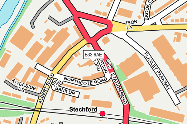
B33 9AE is located in the Glebe Farm & Tile Cross electoral ward, within the metropolitan district of Birmingham and the English Parliamentary constituency of Birmingham, Yardley. The Sub Integrated Care Board (ICB) Location is NHS Birmingham and Solihull ICB - 15E and the police force is West Midlands. This postcode has been in use since January 1980.


GetTheData
Source: OS OpenMap – Local (Ordnance Survey)
Source: OS VectorMap District (Ordnance Survey)
Licence: Open Government Licence (requires attribution)
| Easting | 412893 |
| Northing | 287653 |
| Latitude | 52.486659 |
| Longitude | -1.811556 |
GetTheData
Source: Open Postcode Geo
Licence: Open Government Licence
| Country | England |
| Postcode District | B33 |
| ➜ B33 open data dashboard ➜ See where B33 is on a map ➜ Where is Birmingham? | |
GetTheData
Source: Land Registry Price Paid Data
Licence: Open Government Licence
Elevation or altitude of B33 9AE as distance above sea level:
| Metres | Feet | |
|---|---|---|
| Elevation | 100m | 328ft |
Elevation is measured from the approximate centre of the postcode, to the nearest point on an OS contour line from OS Terrain 50, which has contour spacing of ten vertical metres.
➜ How high above sea level am I? Find the elevation of your current position using your device's GPS.
GetTheData
Source: Open Postcode Elevation
Licence: Open Government Licence
| Ward | Glebe Farm & Tile Cross |
| Constituency | Birmingham, Yardley |
GetTheData
Source: ONS Postcode Database
Licence: Open Government Licence
| January 2024 | Violence and sexual offences | On or near Brook Close | 257m |
| January 2024 | Robbery | On or near Park/Open Space | 307m |
| January 2024 | Violence and sexual offences | On or near Park/Open Space | 307m |
| ➜ Get more crime data in our Crime section | |||
GetTheData
Source: data.police.uk
Licence: Open Government Licence
| Iron Lane (Station Rd) | Stechford | 55m |
| Flaxley Rd (Station Rd) | Stechford | 108m |
| Station Rd (Flaxley Rd) | Stechford | 152m |
| Retail Park (Flaxley Rd) | Stechford | 207m |
| Retail Park (Flaxley Rd) | Stechford | 273m |
| Stechford Station | 0.2km |
| Lea Hall Station | 1.9km |
| Adderley Park Station | 3km |
GetTheData
Source: NaPTAN
Licence: Open Government Licence
GetTheData
Source: ONS Postcode Database
Licence: Open Government Licence


➜ Get more ratings from the Food Standards Agency
GetTheData
Source: Food Standards Agency
Licence: FSA terms & conditions
| Last Collection | |||
|---|---|---|---|
| Location | Mon-Fri | Sat | Distance |
| Lower Stechford Post Office | 17:30 | 11:30 | 246m |
| Stechford Lane / Burney Lane | 17:30 | 11:30 | 462m |
| Stechford Post Office | 17:45 | 11:30 | 683m |
GetTheData
Source: Dracos
Licence: Creative Commons Attribution-ShareAlike
| Facility | Distance |
|---|---|
| The Gym Group (Birmingham Stechford) Flaxley Parkway, Stechford Retail Park, Stechford Retail Park, Birmingham Health and Fitness Gym | 317m |
| Stechford Cascades (Closed) Station Road, Stechford, Birmingham Swimming Pool, Health and Fitness Gym, Studio | 483m |
| Stechford Leisure Centre Station Road, Stechford And Yardley North, Birmingham Swimming Pool, Sports Hall, Health and Fitness Gym, Studio | 564m |
GetTheData
Source: Active Places
Licence: Open Government Licence
| School | Phase of Education | Distance |
|---|---|---|
| Riverside Education 2 Riverside Drive, Stechford, Birmingham, B33 9BF | Not applicable | 258m |
| Blackwater Academy 68-69 Cecil Street, BIRMINGHAM, B19 3SU | Not applicable | 286m |
| St Cuthbert's RC Junior and Infant (NC) School Gumbleberrys Close, Off Cotterills Lane, Stechford, Birmingham, B8 2PS | Primary | 478m |
GetTheData
Source: Edubase
Licence: Open Government Licence
The below table lists the International Territorial Level (ITL) codes (formerly Nomenclature of Territorial Units for Statistics (NUTS) codes) and Local Administrative Units (LAU) codes for B33 9AE:
| ITL 1 Code | Name |
|---|---|
| TLG | West Midlands (England) |
| ITL 2 Code | Name |
| TLG3 | West Midlands |
| ITL 3 Code | Name |
| TLG31 | Birmingham |
| LAU 1 Code | Name |
| E08000025 | Birmingham |
GetTheData
Source: ONS Postcode Directory
Licence: Open Government Licence
The below table lists the Census Output Area (OA), Lower Layer Super Output Area (LSOA), and Middle Layer Super Output Area (MSOA) for B33 9AE:
| Code | Name | |
|---|---|---|
| OA | E00046065 | |
| LSOA | E01009095 | Birmingham 056A |
| MSOA | E02001882 | Birmingham 056 |
GetTheData
Source: ONS Postcode Directory
Licence: Open Government Licence
| B33 9BB | Northcote Road | 58m |
| B33 9BD | Albert Road | 93m |
| B33 9AG | Station Road | 119m |
| B33 9AX | Station Road | 133m |
| B33 9BL | Hill Bank Drive | 140m |
| B33 9AS | Flaxley Road | 168m |
| B33 8AJ | Victoria Road | 214m |
| B33 8AD | Frederick Road | 238m |
| B33 9DW | Brook Close | 262m |
| B33 8BA | Station Road | 277m |
GetTheData
Source: Open Postcode Geo; Land Registry Price Paid Data
Licence: Open Government Licence