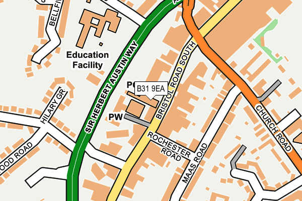
B31 9EA is located in the Northfield electoral ward, within the metropolitan district of Birmingham and the English Parliamentary constituency of Birmingham, Northfield. The Sub Integrated Care Board (ICB) Location is NHS Birmingham and Solihull ICB - 15E and the police force is West Midlands. This postcode has been in use since July 2010.


GetTheData
Source: OS OpenMap – Local (Ordnance Survey)
Source: OS VectorMap District (Ordnance Survey)
Licence: Open Government Licence (requires attribution)
| Easting | 402059 |
| Northing | 279708 |
| Latitude | 52.415366 |
| Longitude | -1.971154 |
GetTheData
Source: Open Postcode Geo
Licence: Open Government Licence
| Country | England |
| Postcode District | B31 |
| ➜ B31 open data dashboard ➜ See where B31 is on a map ➜ Where is Birmingham? | |
GetTheData
Source: Land Registry Price Paid Data
Licence: Open Government Licence
Elevation or altitude of B31 9EA as distance above sea level:
| Metres | Feet | |
|---|---|---|
| Elevation | 180m | 591ft |
Elevation is measured from the approximate centre of the postcode, to the nearest point on an OS contour line from OS Terrain 50, which has contour spacing of ten vertical metres.
➜ How high above sea level am I? Find the elevation of your current position using your device's GPS.
GetTheData
Source: Open Postcode Elevation
Licence: Open Government Licence
| Ward | Northfield |
| Constituency | Birmingham, Northfield |
GetTheData
Source: ONS Postcode Database
Licence: Open Government Licence
| November 2023 | Burglary | On or near Parking Area | 311m |
| November 2023 | Violence and sexual offences | On or near Parking Area | 338m |
| October 2023 | Anti-social behaviour | On or near Parking Area | 311m |
| ➜ Get more crime data in our Crime section | |||
GetTheData
Source: data.police.uk
Licence: Open Government Licence
| Bell Lane (Bristol Road South) | Northfield | 54m |
| Lockwood Rd (Bristol Road South) | Northfield | 74m |
| Bell Lane (Bristol Road South) | Northfield | 80m |
| Lockwood Rd (Bristol Road South) | Northfield | 85m |
| Bell Lane (Bristol Road South) | Northfield | 90m |
| Northfield Station | 0.9km |
| Longbridge Station | 2.2km |
| Kings Norton Station | 2.6km |
GetTheData
Source: NaPTAN
Licence: Open Government Licence
GetTheData
Source: ONS Postcode Database
Licence: Open Government Licence

➜ Get more ratings from the Food Standards Agency
GetTheData
Source: Food Standards Agency
Licence: FSA terms & conditions
| Last Collection | |||
|---|---|---|---|
| Location | Mon-Fri | Sat | Distance |
| Northfield Post Office | 17:45 | 12:30 | 11m |
| Grosvenor Shopping Centre | 17:45 | 12:30 | 253m |
| Bristol Road South / Great Stone | 17:15 | 12:30 | 419m |
GetTheData
Source: Dracos
Licence: Creative Commons Attribution-ShareAlike
| Facility | Distance |
|---|---|
| Northfield Pool & Fitness Centre (Closed) Bristol Road South, Northfield, Birmingham Swimming Pool, Health and Fitness Gym, Studio | 367m |
| Northfield Leisure Centre Bristol Road South, Northfield, Birmingham Health and Fitness Gym, Swimming Pool | 367m |
| Victoria Common (Closed) Bristol Road, Birmingham Grass Pitches | 386m |
GetTheData
Source: Active Places
Licence: Open Government Licence
| School | Phase of Education | Distance |
|---|---|---|
| Bellfield Infant School (NC) Vineyard Road, Birmingham, B31 1PT | Primary | 190m |
| Bellfield Junior School Vineyard Road, Northfield, Birmingham, B31 1PT | Primary | 190m |
| Longwill A Primary School for Deaf Children Bell Hill, Northfield, Birmingham, B31 1LD | Not applicable | 423m |
GetTheData
Source: Edubase
Licence: Open Government Licence
The below table lists the International Territorial Level (ITL) codes (formerly Nomenclature of Territorial Units for Statistics (NUTS) codes) and Local Administrative Units (LAU) codes for B31 9EA:
| ITL 1 Code | Name |
|---|---|
| TLG | West Midlands (England) |
| ITL 2 Code | Name |
| TLG3 | West Midlands |
| ITL 3 Code | Name |
| TLG31 | Birmingham |
| LAU 1 Code | Name |
| E08000025 | Birmingham |
GetTheData
Source: ONS Postcode Directory
Licence: Open Government Licence
The below table lists the Census Output Area (OA), Lower Layer Super Output Area (LSOA), and Middle Layer Super Output Area (MSOA) for B31 9EA:
| Code | Name | |
|---|---|---|
| OA | E00048080 | |
| LSOA | E01009497 | Birmingham 109C |
| MSOA | E02001935 | Birmingham 109 |
GetTheData
Source: ONS Postcode Directory
Licence: Open Government Licence
| B31 2NQ | Bristol Road South | 70m |
| B31 2NN | Bristol Road South | 71m |
| B31 2NP | Bristol Road South | 76m |
| B31 2NG | Bristol Road South | 89m |
| B31 2NR | Rochester Road | 107m |
| B31 2PT | Maas Road | 124m |
| B31 2PS | Maas Road | 150m |
| B31 2JZ | Church Road | 181m |
| B31 2NS | Bristol Road South | 187m |
| B31 2PR | Maas Road | 191m |
GetTheData
Source: Open Postcode Geo; Land Registry Price Paid Data
Licence: Open Government Licence