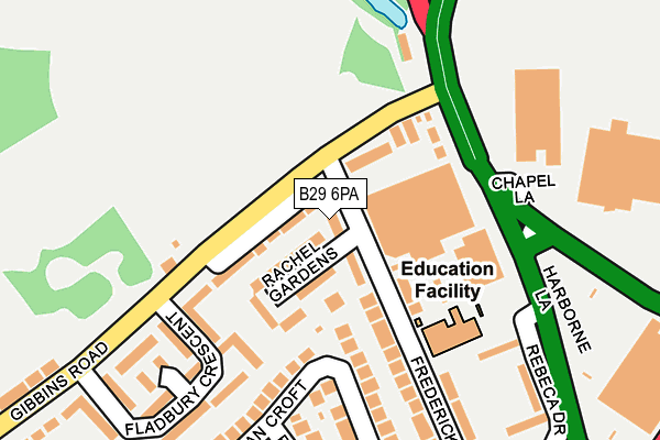
B29 6PA is located in the Weoley & Selly Oak electoral ward, within the metropolitan district of Birmingham and the English Parliamentary constituency of Birmingham, Selly Oak. The Sub Integrated Care Board (ICB) Location is NHS Birmingham and Solihull ICB - 15E and the police force is West Midlands. This postcode has been in use since January 1980.


GetTheData
Source: OS OpenMap – Local (Ordnance Survey)
Source: OS VectorMap District (Ordnance Survey)
Licence: Open Government Licence (requires attribution)
| Easting | 403913 |
| Northing | 282653 |
| Latitude | 52.441832 |
| Longitude | -1.943862 |
GetTheData
Source: Open Postcode Geo
Licence: Open Government Licence
| Country | England |
| Postcode District | B29 |
| ➜ B29 open data dashboard ➜ See where B29 is on a map ➜ Where is Birmingham? | |
GetTheData
Source: Land Registry Price Paid Data
Licence: Open Government Licence
Elevation or altitude of B29 6PA as distance above sea level:
| Metres | Feet | |
|---|---|---|
| Elevation | 140m | 459ft |
Elevation is measured from the approximate centre of the postcode, to the nearest point on an OS contour line from OS Terrain 50, which has contour spacing of ten vertical metres.
➜ How high above sea level am I? Find the elevation of your current position using your device's GPS.
GetTheData
Source: Open Postcode Elevation
Licence: Open Government Licence
| Ward | Weoley & Selly Oak |
| Constituency | Birmingham, Selly Oak |
GetTheData
Source: ONS Postcode Database
Licence: Open Government Licence
| June 2022 | Burglary | On or near Rachel Gardens | 44m |
| June 2022 | Vehicle crime | On or near Rachel Gardens | 44m |
| June 2022 | Violence and sexual offences | On or near Rachel Gardens | 44m |
| ➜ Get more crime data in our Crime section | |||
GetTheData
Source: data.police.uk
Licence: Open Government Licence
| Frederick Rd (Gibbins Rd) | Selly Oak | 57m |
| Frederick Rd (Gibbins Rd) | Selly Oak | 82m |
| Gibbins Rd (Harborne Lane) | Selly Oak | 131m |
| Gibbins Rd (Harborne Lane) | Selly Oak | 149m |
| Lodge Hill Rd (Gibbins Rd) | Selly Oak | 253m |
| Selly Oak Station | 0.5km |
| University Station | 1.2km |
| Bournville Station | 2km |
GetTheData
Source: NaPTAN
Licence: Open Government Licence
| Percentage of properties with Next Generation Access | 100.0% |
| Percentage of properties with Superfast Broadband | 100.0% |
| Percentage of properties with Ultrafast Broadband | 100.0% |
| Percentage of properties with Full Fibre Broadband | 0.0% |
Superfast Broadband is between 30Mbps and 300Mbps
Ultrafast Broadband is > 300Mbps
| Percentage of properties unable to receive 2Mbps | 0.0% |
| Percentage of properties unable to receive 5Mbps | 0.0% |
| Percentage of properties unable to receive 10Mbps | 0.0% |
| Percentage of properties unable to receive 30Mbps | 0.0% |
GetTheData
Source: Ofcom
Licence: Ofcom Terms of Use (requires attribution)
GetTheData
Source: ONS Postcode Database
Licence: Open Government Licence


➜ Get more ratings from the Food Standards Agency
GetTheData
Source: Food Standards Agency
Licence: FSA terms & conditions
| Last Collection | |||
|---|---|---|---|
| Location | Mon-Fri | Sat | Distance |
| Fladbury Cescent | 17:30 | 12:30 | 141m |
| Wellman Croft / Lodge Hill Roa | 17:30 | 12:30 | 319m |
| Selly Oak Post Office | 17:15 | 12:30 | 445m |
GetTheData
Source: Dracos
Licence: Creative Commons Attribution-ShareAlike
| Facility | Distance |
|---|---|
| The Gym Group (Birmingham Selly Oak) Chapel Lane, Birmingham Health and Fitness Gym | 325m |
| Harborne Rugby Club (Westhill Playing Field) Westhill Close, Birmingham Grass Pitches | 559m |
| University Of Birmingham School Weoley Park Road, Birmingham Sports Hall, Studio | 777m |
GetTheData
Source: Active Places
Licence: Open Government Licence
| School | Phase of Education | Distance |
|---|---|---|
| Cherry Oak School 60 Frederick Road, Selly Oak, Birmingham, B29 6PB | Not applicable | 142m |
| St Mary's Church of England Primary School Lodge Hill Road, Selly Oak, Birmingham, B29 6NU | Primary | 320m |
| Water Mill Primary School Water Mill Close, Selly Oak, Birmingham, B29 6TS | Primary | 469m |
GetTheData
Source: Edubase
Licence: Open Government Licence
The below table lists the International Territorial Level (ITL) codes (formerly Nomenclature of Territorial Units for Statistics (NUTS) codes) and Local Administrative Units (LAU) codes for B29 6PA:
| ITL 1 Code | Name |
|---|---|
| TLG | West Midlands (England) |
| ITL 2 Code | Name |
| TLG3 | West Midlands |
| ITL 3 Code | Name |
| TLG31 | Birmingham |
| LAU 1 Code | Name |
| E08000025 | Birmingham |
GetTheData
Source: ONS Postcode Directory
Licence: Open Government Licence
The below table lists the Census Output Area (OA), Lower Layer Super Output Area (LSOA), and Middle Layer Super Output Area (MSOA) for B29 6PA:
| Code | Name | |
|---|---|---|
| OA | E00175801 | |
| LSOA | E01009284 | Birmingham 096A |
| MSOA | E02001922 | Birmingham 096 |
GetTheData
Source: ONS Postcode Directory
Licence: Open Government Licence
| B29 6NY | Rachel Gardens | 74m |
| B29 6PQ | Gibbins Road | 82m |
| B29 6PG | Gibbins Road | 97m |
| B29 6SN | Harborne Lane | 117m |
| B29 6SP | Harborne Lane | 141m |
| B29 6NR | Wellman Croft | 155m |
| B29 6PH | Fladbury Crescent | 179m |
| B29 6NX | Frederick Road | 183m |
| B29 6NT | Pegasus Walk | 196m |
| B29 6PL | Fladbury Crescent | 209m |
GetTheData
Source: Open Postcode Geo; Land Registry Price Paid Data
Licence: Open Government Licence