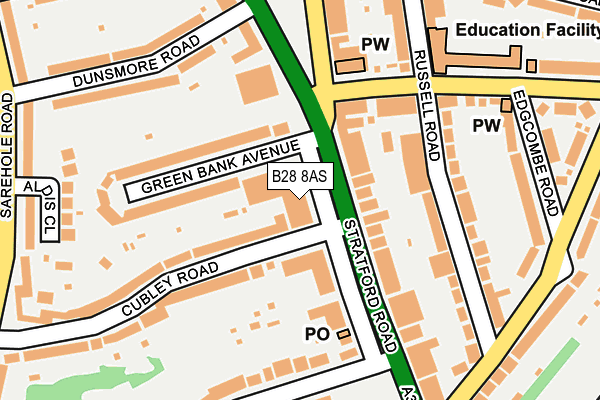
B28 8AS lies on Stratford Road in Hall Green, Birmingham. B28 8AS is located in the Hall Green North electoral ward, within the metropolitan district of Birmingham and the English Parliamentary constituency of Birmingham, Hall Green. The Sub Integrated Care Board (ICB) Location is NHS Birmingham and Solihull ICB - 15E and the police force is West Midlands. This postcode has been in use since January 1980.


GetTheData
Source: OS OpenMap – Local (Ordnance Survey)
Source: OS VectorMap District (Ordnance Survey)
Licence: Open Government Licence (requires attribution)
| Easting | 410364 |
| Northing | 282405 |
| Latitude | 52.439519 |
| Longitude | -1.848966 |
GetTheData
Source: Open Postcode Geo
Licence: Open Government Licence
| Street | Stratford Road |
| Locality | Hall Green |
| Town/City | Birmingham |
| Country | England |
| Postcode District | B28 |
| ➜ B28 open data dashboard ➜ See where B28 is on a map ➜ Where is Birmingham? | |
GetTheData
Source: Land Registry Price Paid Data
Licence: Open Government Licence
Elevation or altitude of B28 8AS as distance above sea level:
| Metres | Feet | |
|---|---|---|
| Elevation | 130m | 427ft |
Elevation is measured from the approximate centre of the postcode, to the nearest point on an OS contour line from OS Terrain 50, which has contour spacing of ten vertical metres.
➜ How high above sea level am I? Find the elevation of your current position using your device's GPS.
GetTheData
Source: Open Postcode Elevation
Licence: Open Government Licence
| Ward | Hall Green North |
| Constituency | Birmingham, Hall Green |
GetTheData
Source: ONS Postcode Database
Licence: Open Government Licence
| January 2024 | Violence and sexual offences | On or near Parking Area | 346m |
| December 2023 | Violence and sexual offences | On or near Parking Area | 346m |
| December 2023 | Violence and sexual offences | On or near Green Road | 426m |
| ➜ Get more crime data in our Crime section | |||
GetTheData
Source: data.police.uk
Licence: Open Government Licence
| York Rd (Stratford Rd) | Hall Green | 34m |
| York Rd (Stratford Rd) | Hall Green | 53m |
| Edgcombe Road (York Rd) | Hall Green | 246m |
| Hall Green Rail Station (Stratford Rd) | Hall Green | 249m |
| Edgcombe Road (Cateswell Rd) | Hall Green | 264m |
| Hall Green Station | 0.4km |
| Spring Road Station | 0.9km |
| Tyseley Station | 1.8km |
GetTheData
Source: NaPTAN
Licence: Open Government Licence
GetTheData
Source: ONS Postcode Database
Licence: Open Government Licence


➜ Get more ratings from the Food Standards Agency
GetTheData
Source: Food Standards Agency
Licence: FSA terms & conditions
| Last Collection | |||
|---|---|---|---|
| Location | Mon-Fri | Sat | Distance |
| Colebank Post Office | 17:45 | 11:30 | 141m |
| Dunsmore Road / Stratford Road | 17:45 | 11:30 | 236m |
| Opp 9 Cateswell Road Near Russel | 17:15 | 11:30 | 249m |
GetTheData
Source: Dracos
Licence: Creative Commons Attribution-ShareAlike
| Facility | Distance |
|---|---|
| South And City College Birmingham (Hall Green Campus) Cole Bank Road, Hall Green, Birmingham Sports Hall, Health and Fitness Gym | 607m |
| Hall Green School Southam Road, Birmingham Health and Fitness Gym, Sports Hall, Studio, Artificial Grass Pitch | 734m |
| Moseley School Health And Fitness Centre College Road, Springfield, Birmingham Sports Hall, Health and Fitness Gym, Artificial Grass Pitch, Studio, Grass Pitches, Outdoor Tennis Courts | 887m |
GetTheData
Source: Active Places
Licence: Open Government Licence
| School | Phase of Education | Distance |
|---|---|---|
| Yorkmead Junior and Infant School York Road, Hall Green, Birmingham, B28 8BB | Primary | 223m |
| Hall Green School Southam Road, Hall Green, Birmingham, B28 0AA | Secondary | 734m |
| Aspire Ap School Hall Green Baptist Church, 1250 Stratford Road, Birmingham, B28 9EJ | Not applicable | 742m |
GetTheData
Source: Edubase
Licence: Open Government Licence
The below table lists the International Territorial Level (ITL) codes (formerly Nomenclature of Territorial Units for Statistics (NUTS) codes) and Local Administrative Units (LAU) codes for B28 8AS:
| ITL 1 Code | Name |
|---|---|
| TLG | West Midlands (England) |
| ITL 2 Code | Name |
| TLG3 | West Midlands |
| ITL 3 Code | Name |
| TLG31 | Birmingham |
| LAU 1 Code | Name |
| E08000025 | Birmingham |
GetTheData
Source: ONS Postcode Directory
Licence: Open Government Licence
The below table lists the Census Output Area (OA), Lower Layer Super Output Area (LSOA), and Middle Layer Super Output Area (MSOA) for B28 8AS:
| Code | Name | |
|---|---|---|
| OA | E00045843 | |
| LSOA | E01009045 | Birmingham 097D |
| MSOA | E02001923 | Birmingham 097 |
GetTheData
Source: ONS Postcode Directory
Licence: Open Government Licence
| B28 8AT | Stratford Road | 64m |
| B28 8AD | Stratford Road | 72m |
| B28 8EH | Cubley Road | 104m |
| B28 8AE | Stratford Road | 110m |
| B28 8AP | Green Bank Avenue | 126m |
| B28 8AR | Green Bank Avenue | 131m |
| B28 8BD | York Road | 133m |
| B28 8AU | Stratford Road | 146m |
| B28 8SF | Russell Road | 157m |
| B28 8BG | Stratford Road | 165m |
GetTheData
Source: Open Postcode Geo; Land Registry Price Paid Data
Licence: Open Government Licence