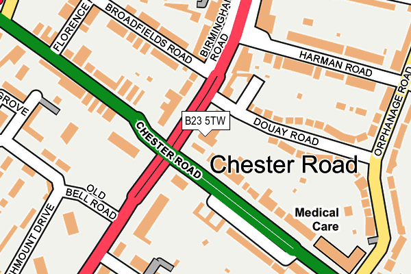
B23 5TW is located in the Erdington electoral ward, within the metropolitan district of Birmingham and the English Parliamentary constituency of Birmingham, Erdington. The Sub Integrated Care Board (ICB) Location is NHS Birmingham and Solihull ICB - 15E and the police force is West Midlands. This postcode has been in use since January 1980.


GetTheData
Source: OS OpenMap – Local (Ordnance Survey)
Source: OS VectorMap District (Ordnance Survey)
Licence: Open Government Licence (requires attribution)
| Easting | 411769 |
| Northing | 292904 |
| Latitude | 52.533891 |
| Longitude | -1.827923 |
GetTheData
Source: Open Postcode Geo
Licence: Open Government Licence
| Country | England |
| Postcode District | B23 |
| ➜ B23 open data dashboard ➜ See where B23 is on a map ➜ Where is Birmingham? | |
GetTheData
Source: Land Registry Price Paid Data
Licence: Open Government Licence
Elevation or altitude of B23 5TW as distance above sea level:
| Metres | Feet | |
|---|---|---|
| Elevation | 130m | 427ft |
Elevation is measured from the approximate centre of the postcode, to the nearest point on an OS contour line from OS Terrain 50, which has contour spacing of ten vertical metres.
➜ How high above sea level am I? Find the elevation of your current position using your device's GPS.
GetTheData
Source: Open Postcode Elevation
Licence: Open Government Licence
| Ward | Erdington |
| Constituency | Birmingham, Erdington |
GetTheData
Source: ONS Postcode Database
Licence: Open Government Licence
| January 2024 | Criminal damage and arson | On or near Parking Area | 328m |
| January 2024 | Violence and sexual offences | On or near Parking Area | 328m |
| January 2024 | Violence and sexual offences | On or near Parking Area | 328m |
| ➜ Get more crime data in our Crime section | |||
GetTheData
Source: data.police.uk
Licence: Open Government Licence
| The Yenton (Birmingham Rd) | Yenton | 49m |
| The Yenton (Chester Rd) | Yenton | 73m |
| The Yenton (Chester Rd) | Yenton | 81m |
| Birmingham Rd (Broadfields Rd) | Yenton | 83m |
| Birmingham Rd (Broadfields Rd) | Yenton | 92m |
| Chester Road Station | 0.4km |
| Erdington Station | 1km |
| Wylde Green Station | 1.3km |
GetTheData
Source: NaPTAN
Licence: Open Government Licence
GetTheData
Source: ONS Postcode Database
Licence: Open Government Licence


➜ Get more ratings from the Food Standards Agency
GetTheData
Source: Food Standards Agency
Licence: FSA terms & conditions
| Last Collection | |||
|---|---|---|---|
| Location | Mon-Fri | Sat | Distance |
| Berwood | 17:30 | 12:15 | 341m |
| Holifast Road / Orphanage Road | 17:15 | 12:00 | 351m |
| Chester Road Station | 17:15 | 12:00 | 406m |
GetTheData
Source: Dracos
Licence: Creative Commons Attribution-ShareAlike
| Facility | Distance |
|---|---|
| Malcolm Locker Youth Centre (Closed) Rowden Drive, Rowden Drive, Birmingham Artificial Grass Pitch | 212m |
| St Edmund Campion Catholic School Sutton Road, Birmingham Health and Fitness Gym, Sports Hall, Artificial Grass Pitch | 435m |
| Wylde Green Primary School Green Lanes, Wylde Green, Sutton Coldfield Grass Pitches | 467m |
GetTheData
Source: Active Places
Licence: Open Government Licence
| School | Phase of Education | Distance |
|---|---|---|
| St Edmund Campion Catholic School Sutton Road, Erdington, Birmingham, B23 5XA | Secondary | 435m |
| Yenton Primary School Chester Road, Erdington, Birmingham, B24 0ED | Primary | 451m |
| Wylde Green Primary School Green Lanes, Sutton Coldfield, B73 5JL | Primary | 467m |
GetTheData
Source: Edubase
Licence: Open Government Licence
The below table lists the International Territorial Level (ITL) codes (formerly Nomenclature of Territorial Units for Statistics (NUTS) codes) and Local Administrative Units (LAU) codes for B23 5TW:
| ITL 1 Code | Name |
|---|---|
| TLG | West Midlands (England) |
| ITL 2 Code | Name |
| TLG3 | West Midlands |
| ITL 3 Code | Name |
| TLG31 | Birmingham |
| LAU 1 Code | Name |
| E08000025 | Birmingham |
GetTheData
Source: ONS Postcode Directory
Licence: Open Government Licence
The below table lists the Census Output Area (OA), Lower Layer Super Output Area (LSOA), and Middle Layer Super Output Area (MSOA) for B23 5TW:
| Code | Name | |
|---|---|---|
| OA | E00045720 | |
| LSOA | E01009003 | Birmingham 018B |
| MSOA | E02001844 | Birmingham 018 |
GetTheData
Source: ONS Postcode Directory
Licence: Open Government Licence
| B23 5TJ | Sutton Road | 66m |
| B23 5TN | Sutton Road | 75m |
| B24 0BY | Chester Road | 86m |
| B24 0BA | Douay Road | 121m |
| B72 1YJ | Birmingham Road | 134m |
| B24 0BG | Douay Road | 148m |
| B24 0EB | Chester Road | 153m |
| B23 5TH | Chester Road | 156m |
| B23 5TL | Broadfields Road | 157m |
| B72 1AX | Birmingham Road | 190m |
GetTheData
Source: Open Postcode Geo; Land Registry Price Paid Data
Licence: Open Government Licence