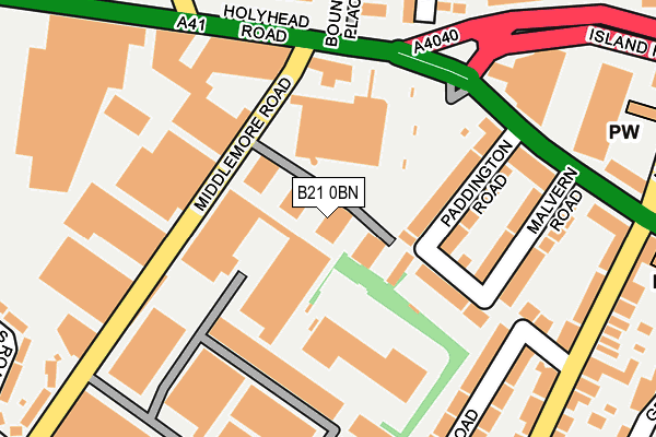
B21 0BN is located in the Holyhead electoral ward, within the metropolitan district of Birmingham and the English Parliamentary constituency of Birmingham, Ladywood. The Sub Integrated Care Board (ICB) Location is NHS Birmingham and Solihull ICB - 15E and the police force is West Midlands. This postcode has been in use since April 2008.


GetTheData
Source: OS OpenMap – Local (Ordnance Survey)
Source: OS VectorMap District (Ordnance Survey)
Licence: Open Government Licence (requires attribution)
| Easting | 402961 |
| Northing | 290016 |
| Latitude | 52.508030 |
| Longitude | -1.957804 |
GetTheData
Source: Open Postcode Geo
Licence: Open Government Licence
| Country | England |
| Postcode District | B21 |
| ➜ B21 open data dashboard ➜ See where B21 is on a map ➜ Where is Birmingham? | |
GetTheData
Source: Land Registry Price Paid Data
Licence: Open Government Licence
Elevation or altitude of B21 0BN as distance above sea level:
| Metres | Feet | |
|---|---|---|
| Elevation | 160m | 525ft |
Elevation is measured from the approximate centre of the postcode, to the nearest point on an OS contour line from OS Terrain 50, which has contour spacing of ten vertical metres.
➜ How high above sea level am I? Find the elevation of your current position using your device's GPS.
GetTheData
Source: Open Postcode Elevation
Licence: Open Government Licence
| Ward | Holyhead |
| Constituency | Birmingham, Ladywood |
GetTheData
Source: ONS Postcode Database
Licence: Open Government Licence
| January 2024 | Vehicle crime | On or near Raleigh Close | 375m |
| December 2023 | Criminal damage and arson | On or near Raleigh Close | 375m |
| December 2023 | Violence and sexual offences | On or near Raleigh Close | 375m |
| ➜ Get more crime data in our Crime section | |||
GetTheData
Source: data.police.uk
Licence: Open Government Licence
| Middlemore Rd (Holyhead Rd) | Leveretts | 169m |
| Island Rd (Holyhead Rd) | Leveretts | 191m |
| Island Rd (Holyhead Rd) | Leveretts | 197m |
| Holyhead Rd (Island Rd) | Leveretts | 244m |
| Holyhead Rd (Island Rd) | Leveretts | 247m |
| The Hawthorns (Midland Metro Stop) (Middlemore Lane) | Smethwick | 530m |
| Handsworth Booth Street (Midland Metro Stop) (Booth Street) | Handsworth | 776m |
| Winson Green Outer Circle (Midland Metro Stop) (Boulton Road) | Winson Green | 1,655m |
| The Hawthorns Station | 0.5km |
| Smethwick Rolfe Street Station | 1.6km |
| Smethwick Galton Bridge Station | 1.7km |
GetTheData
Source: NaPTAN
Licence: Open Government Licence
GetTheData
Source: ONS Postcode Database
Licence: Open Government Licence


➜ Get more ratings from the Food Standards Agency
GetTheData
Source: Food Standards Agency
Licence: FSA terms & conditions
| Last Collection | |||
|---|---|---|---|
| Location | Mon-Fri | Sat | Distance |
| Holyhead Road / Middlemore Road | 17:45 | 12:30 | 210m |
| Watville Road Post Office | 17:30 | 12:30 | 310m |
| St Stephens Road / Albion Road | 17:30 | 12:00 | 370m |
GetTheData
Source: Dracos
Licence: Creative Commons Attribution-ShareAlike
| Facility | Distance |
|---|---|
| West Bromwich Albion (The Hawthorns) Halfords Lane, West Bromwich Grass Pitches | 388m |
| West Bromwich Albion Fc Academy Halfords Lane, West Bromwich Sports Hall, Artificial Grass Pitch | 562m |
| Sandwell Academy Halfords Lane, West Bromwich Sports Hall, Health and Fitness Gym, Artificial Grass Pitch, Studio, Grass Pitches, Athletics | 686m |
GetTheData
Source: Active Places
Licence: Open Government Licence
| School | Phase of Education | Distance |
|---|---|---|
| Wattville Primary School Wattville Road, Handsworth, Birmingham, B21 0DP | Primary | 437m |
| St James Church of England Primary School, Handsworth Sandwell Road, Birmingham, B21 8NH | Primary | 574m |
| Sandwell Academy Halfords Lane, West Bromwich, B71 4LG | Secondary | 685m |
GetTheData
Source: Edubase
Licence: Open Government Licence
The below table lists the International Territorial Level (ITL) codes (formerly Nomenclature of Territorial Units for Statistics (NUTS) codes) and Local Administrative Units (LAU) codes for B21 0BN:
| ITL 1 Code | Name |
|---|---|
| TLG | West Midlands (England) |
| ITL 2 Code | Name |
| TLG3 | West Midlands |
| ITL 3 Code | Name |
| TLG31 | Birmingham |
| LAU 1 Code | Name |
| E08000025 | Birmingham |
GetTheData
Source: ONS Postcode Directory
Licence: Open Government Licence
The below table lists the Census Output Area (OA), Lower Layer Super Output Area (LSOA), and Middle Layer Super Output Area (MSOA) for B21 0BN:
| Code | Name | |
|---|---|---|
| OA | E00047405 | |
| LSOA | E01009349 | Birmingham 036D |
| MSOA | E02001862 | Birmingham 036 |
GetTheData
Source: ONS Postcode Directory
Licence: Open Government Licence
| B21 0AR | Paddington Road | 111m |
| B21 0AP | Holyhead Road | 133m |
| B21 0AU | Belmont Road | 146m |
| B21 0AT | Malvern Road | 193m |
| B21 0AX | Kentish Road | 203m |
| B21 0AS | Holyhead Road | 206m |
| B21 0AW | Belmont Road East | 208m |
| B21 0LE | Holyhead Road | 218m |
| B21 0DS | Wattville Road | 245m |
| B21 0BB | Kentish Road | 247m |
GetTheData
Source: Open Postcode Geo; Land Registry Price Paid Data
Licence: Open Government Licence