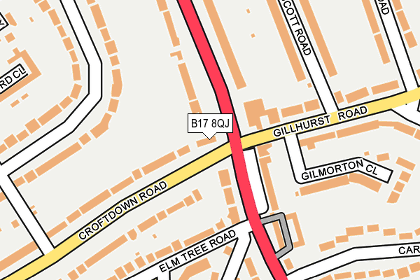
B17 8QJ is located in the Quinton electoral ward, within the metropolitan district of Birmingham and the English Parliamentary constituency of Birmingham, Edgbaston. The Sub Integrated Care Board (ICB) Location is NHS Birmingham and Solihull ICB - 15E and the police force is West Midlands. This postcode has been in use since January 1980.


GetTheData
Source: OS OpenMap – Local (Ordnance Survey)
Source: OS VectorMap District (Ordnance Survey)
Licence: Open Government Licence (requires attribution)
| Easting | 402417 |
| Northing | 285195 |
| Latitude | 52.464692 |
| Longitude | -1.965852 |
GetTheData
Source: Open Postcode Geo
Licence: Open Government Licence
| Country | England |
| Postcode District | B17 |
| ➜ B17 open data dashboard ➜ See where B17 is on a map ➜ Where is Birmingham? | |
GetTheData
Source: Land Registry Price Paid Data
Licence: Open Government Licence
Elevation or altitude of B17 8QJ as distance above sea level:
| Metres | Feet | |
|---|---|---|
| Elevation | 180m | 591ft |
Elevation is measured from the approximate centre of the postcode, to the nearest point on an OS contour line from OS Terrain 50, which has contour spacing of ten vertical metres.
➜ How high above sea level am I? Find the elevation of your current position using your device's GPS.
GetTheData
Source: Open Postcode Elevation
Licence: Open Government Licence
| Ward | Quinton |
| Constituency | Birmingham, Edgbaston |
GetTheData
Source: ONS Postcode Database
Licence: Open Government Licence
| November 2023 | Other theft | On or near Wintney Close | 366m |
| April 2023 | Vehicle crime | On or near Leigham Drive | 367m |
| November 2022 | Burglary | On or near Wintney Close | 366m |
| ➜ Get more crime data in our Crime section | |||
GetTheData
Source: data.police.uk
Licence: Open Government Licence
| Lordswood Rd (Croftdown Rd) | Court Oak | 21m |
| Gillhurst Rd (Lordswood Rd) | Court Oak | 55m |
| Gillhurst Rd (Lordswood Rd) | Court Oak | 76m |
| Lordswood Rd (Gillhurst Rd) | Moor Pool | 90m |
| Elm Tree Rd (Lordswood Rd) | Court Oak | 125m |
| University Station | 2.5km |
| Selly Oak Station | 3.2km |
| Smethwick Rolfe Street Station | 3.5km |
GetTheData
Source: NaPTAN
Licence: Open Government Licence
GetTheData
Source: ONS Postcode Database
Licence: Open Government Licence


➜ Get more ratings from the Food Standards Agency
GetTheData
Source: Food Standards Agency
Licence: FSA terms & conditions
| Last Collection | |||
|---|---|---|---|
| Location | Mon-Fri | Sat | Distance |
| Gillhurst Road / Ellesboro Road | 17:30 | 12:00 | 249m |
| Croftdown Road Opposite Fitzro | 17:30 | 12:00 | 277m |
| Lordswood Road / Wentworth Road | 17:30 | 12:00 | 310m |
GetTheData
Source: Dracos
Licence: Creative Commons Attribution-ShareAlike
| Facility | Distance |
|---|---|
| Qac Fitness Centre Wood Lane, Harborne, Birmingham Health and Fitness Gym, Sports Hall | 284m |
| Lordswood Girls School Knightlow Road, Birmingham Sports Hall, Artificial Grass Pitch | 541m |
| The Circle Tennis Club The Circle, Birmingham Outdoor Tennis Courts | 654m |
GetTheData
Source: Active Places
Licence: Open Government Licence
| School | Phase of Education | Distance |
|---|---|---|
| Queen Alexandra College 49 Court Oak Road, Harborne, Birmingham, B17 9TG | Not applicable | 496m |
| King Edward VI Lordswood School for Girls Knightlow Road, Harborne, Birmingham, B17 8QB | Secondary | 537m |
| Our Lady of Fatima Catholic Primary School Winchfield Drive, Harborne, Birmingham, B17 8TR | Primary | 722m |
GetTheData
Source: Edubase
Licence: Open Government Licence
The below table lists the International Territorial Level (ITL) codes (formerly Nomenclature of Territorial Units for Statistics (NUTS) codes) and Local Administrative Units (LAU) codes for B17 8QJ:
| ITL 1 Code | Name |
|---|---|
| TLG | West Midlands (England) |
| ITL 2 Code | Name |
| TLG3 | West Midlands |
| ITL 3 Code | Name |
| TLG31 | Birmingham |
| LAU 1 Code | Name |
| E08000025 | Birmingham |
GetTheData
Source: ONS Postcode Directory
Licence: Open Government Licence
The below table lists the Census Output Area (OA), Lower Layer Super Output Area (LSOA), and Middle Layer Super Output Area (MSOA) for B17 8QJ:
| Code | Name | |
|---|---|---|
| OA | E00046912 | |
| LSOA | E01009260 | Birmingham 073D |
| MSOA | E02001899 | Birmingham 073 |
GetTheData
Source: ONS Postcode Directory
Licence: Open Government Licence
| B17 9BT | Lordswood Road | 77m |
| B17 9BP | Lordswood Road | 123m |
| B17 8QH | Lordswood Road | 130m |
| B17 8QP | Lordswood Road | 134m |
| B17 8AR | Hamilton Avenue | 147m |
| B17 8RA | Croftdown Road | 152m |
| B17 9BS | Lordswood Square | 167m |
| B17 8RB | Croftdown Road | 173m |
| B17 9AP | Elm Tree Road | 180m |
| B17 8QW | Kelmscott Road | 191m |
GetTheData
Source: Open Postcode Geo; Land Registry Price Paid Data
Licence: Open Government Licence