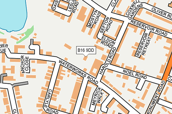
B16 9DD is located in the North Edgbaston electoral ward, within the metropolitan district of Birmingham and the English Parliamentary constituency of Birmingham, Edgbaston. The Sub Integrated Care Board (ICB) Location is NHS Birmingham and Solihull ICB - 15E and the police force is West Midlands. This postcode has been in use since January 1980.


GetTheData
Source: OS OpenMap – Local (Ordnance Survey)
Source: OS VectorMap District (Ordnance Survey)
Licence: Open Government Licence (requires attribution)
| Easting | 404618 |
| Northing | 286428 |
| Latitude | 52.475763 |
| Longitude | -1.933439 |
GetTheData
Source: Open Postcode Geo
Licence: Open Government Licence
| Country | England |
| Postcode District | B16 |
| ➜ B16 open data dashboard ➜ See where B16 is on a map ➜ Where is Birmingham? | |
GetTheData
Source: Land Registry Price Paid Data
Licence: Open Government Licence
Elevation or altitude of B16 9DD as distance above sea level:
| Metres | Feet | |
|---|---|---|
| Elevation | 160m | 525ft |
Elevation is measured from the approximate centre of the postcode, to the nearest point on an OS contour line from OS Terrain 50, which has contour spacing of ten vertical metres.
➜ How high above sea level am I? Find the elevation of your current position using your device's GPS.
GetTheData
Source: Open Postcode Elevation
Licence: Open Government Licence
| Ward | North Edgbaston |
| Constituency | Birmingham, Edgbaston |
GetTheData
Source: ONS Postcode Database
Licence: Open Government Licence
| January 2024 | Robbery | On or near Parker Street | 286m |
| January 2024 | Public order | On or near Parking Area | 305m |
| January 2024 | Public order | On or near Parking Area | 305m |
| ➜ Get more crime data in our Crime section | |||
GetTheData
Source: data.police.uk
Licence: Open Government Licence
| Water Works Rd (Monument Rd) | Ladywood | 283m |
| Monument Rd (Plough And Harrow Rd) | Ladywood | 348m |
| Darnley Rd (Alston St) | Ladywood | 360m |
| Parker St (Monument Rd) | Botanical Gardens | 373m |
| Darnley Rd (Alston St) | Ladywood | 389m |
| Five Ways Station | 1.5km |
| Jewellery Quarter Station | 2km |
| Birmingham New Street Station | 2.3km |
GetTheData
Source: NaPTAN
Licence: Open Government Licence
GetTheData
Source: ONS Postcode Database
Licence: Open Government Licence


➜ Get more ratings from the Food Standards Agency
GetTheData
Source: Food Standards Agency
Licence: FSA terms & conditions
| Last Collection | |||
|---|---|---|---|
| Location | Mon-Fri | Sat | Distance |
| Stirling Road | 17:30 | 12:30 | 73m |
| 53 Reservoir Road | 17:30 | 12:30 | 222m |
| Ivy Bush Post Office | 18:30 | 12:30 | 345m |
GetTheData
Source: Dracos
Licence: Creative Commons Attribution-ShareAlike
| Facility | Distance |
|---|---|
| St Paul's School For Girls Vernon Road, Birmingham Sports Hall, Health and Fitness Gym, Grass Pitches, Studio | 423m |
| St Georges C Of E Primary School (Edgbaston) Beaufort Road, Edgbaston, Birmingham Sports Hall, Artificial Grass Pitch | 446m |
| Ladywood Leisure Centre Ladywood Middleway, Birmingham Swimming Pool, Health and Fitness Gym, Studio | 602m |
GetTheData
Source: Active Places
Licence: Open Government Licence
| School | Phase of Education | Distance |
|---|---|---|
| The Oratory Roman Catholic Primary School Oliver Road, Ladywood, Birmingham, B16 9ER | Primary | 381m |
| St George's Church of England Primary School Beaufort Road, Edgbaston, Birmingham, B16 8HY | Primary | 446m |
| St Paul's School for Girls Vernon Road, Edgbaston, Birmingham, B16 9SL | Secondary | 498m |
GetTheData
Source: Edubase
Licence: Open Government Licence
The below table lists the International Territorial Level (ITL) codes (formerly Nomenclature of Territorial Units for Statistics (NUTS) codes) and Local Administrative Units (LAU) codes for B16 9DD:
| ITL 1 Code | Name |
|---|---|
| TLG | West Midlands (England) |
| ITL 2 Code | Name |
| TLG3 | West Midlands |
| ITL 3 Code | Name |
| TLG31 | Birmingham |
| LAU 1 Code | Name |
| E08000025 | Birmingham |
GetTheData
Source: ONS Postcode Directory
Licence: Open Government Licence
The below table lists the Census Output Area (OA), Lower Layer Super Output Area (LSOA), and Middle Layer Super Output Area (MSOA) for B16 9DD:
| Code | Name | |
|---|---|---|
| OA | E00045661 | |
| LSOA | E01008987 | Birmingham 064B |
| MSOA | E02001890 | Birmingham 064 |
GetTheData
Source: ONS Postcode Directory
Licence: Open Government Licence
| B16 9DW | Harold Road | 82m |
| B16 9DE | Norwood Villas | 96m |
| B16 9DP | Eldon Road | 103m |
| B16 9DR | Sefton Road | 116m |
| B16 9DU | Mostyn Road | 124m |
| B16 9DA | Harold Road | 125m |
| B16 9BL | Stirling Road | 143m |
| B16 9DN | Harold Road | 145m |
| B16 9PS | Noel Road | 146m |
| B16 9DS | Reservoir Road | 157m |
GetTheData
Source: Open Postcode Geo; Land Registry Price Paid Data
Licence: Open Government Licence